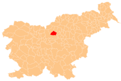
- Gornji Grad, Slovenia
-
This article is about municipality in Slovenia. For other uses, see Gornji Grad (disambiguation).
Gornji Grad
Občina Gornji Grad— Town and Municipality — Gornji Grad Location of the Municipality of Gornji Grad in Slovenia Location of the Town of Gornji Grad in Slovenia Coordinates: 46°18′N 14°48′E / 46.3°N 14.8°ECoordinates: 46°18′N 14°48′E / 46.3°N 14.8°E Country  Slovenia
Government - Mayor Stanko Ogradi Area - Total 90.1 km2 (34.8 sq mi) Population (2002)[1] - Total 2,595 - Density 28.8/km2 (74.6/sq mi) Time zone CET (UTC+01) - Summer (DST) CEST (UTC+02) Gornji Grad (German: Oberburg in Steiermark) is a town and a municipality in Slovenia. It lies on the Dreta River at the foothills of the Savinja Alps. Traditionally it belonged to the region of Styria and is now included in the Savinja statistical region.[2]
Gornji Grad has a rich history. In 1140 a Benedictine monastery was built in the settlement. In the 15th century it became the summer residence of the Bishops of Ljubljana. The Baroque parish church in the settlement is dedicated to Saints Hermagoras and Fortunatus. It is a large church with a dome over its transept. It contains 18th-century altar paintings and the tombs of the first bishops of Ljubljana.[3]
References
- ^ Statistical Office of the Republic of Slovenia, census of 2002
- ^ Gornji Grad municipal site
- ^ Slovenian Ministry of Culture register of national heritage reference number 152
External links
Gornji Grad Settlements Administrative centre: Gornji Grad
Bočna, Dol, Florjan pri Gornjem Gradu, Lenart pri Gornjem Gradu, Nova ŠtiftaLandmarks Church of Saints Fortunatus and Hermagoras, Church of Saint Nicholas, Saint Mary the StarCategories:- Municipalities of Slovenia
- Populated places in the Municipality of Gornji Grad
- Savinjska statistical region geography stubs
Wikimedia Foundation. 2010.


