- Cleeve, Somerset
-
Coordinates: 51°23′25″N 2°46′26″W / 51.3904°N 2.7740°W
Cleeve 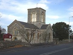
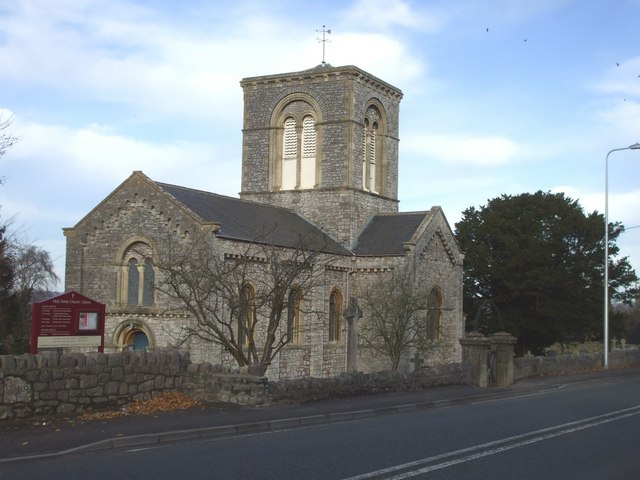
Holy Trinity Church, Cleeve
 Cleeve
Cleeve shown within SomersetPopulation 941 [1] OS grid reference ST461660 Unitary authority North Somerset Ceremonial county Somerset Region South West Country England Sovereign state United Kingdom Post town Bristol Postcode district BS49 Dialling code 01934 Police Avon and Somerset Fire Avon Ambulance Great Western EU Parliament South West England UK Parliament Woodspring to become North Somerset at next general election Website http://www.cleevevillage.co.uk List of places: UK • England • Somerset Cleeve is a village and civil parish in the ceremonial county of Somerset, England. It is situated within the unitary authority of North Somerset, 9 miles (14 km) south west of Bristol and has a population of 941 (2001 census).[1]
Contents
History
Bronze or Iron age hill forts have been identified north of Goblin Combe close to the village at Cleeve Toot in Cleeve Wood.[2] It is a roughly oval settlement which is approximately 125 metres (410 ft) in length by 90 metres (300 ft) in breadth. Approximately 150 metres (490 ft) to the north is another, smaller settlement. They are thought to have been a satellite community of nearby Cadbury Hill[3] Pits have been found at the site indicating the presence of round houses.[4] There is a single stone rampart with a broad shallow outer ditch. There is also a prehistoric or Roman field system.[5]
Governance
The parish council has responsibility for local issues, including setting an annual precept (local rate) to cover the council’s operating costs and producing annual accounts for public scrutiny. The parish council evaluates local planning applications and works with the local police, district council officers, and neighbourhood watch groups on matters of crime, security, and traffic. The parish council's role also includes initiating projects for the maintenance and repair of parish facilities, such as the village hall or community centre, playing fields and playgrounds, as well as consulting with the district council on the maintenance, repair, and improvement of highways, drainage, footpaths, public transport, and street cleaning. Conservation matters (including trees and listed buildings) and environmental issues are also of interest to the council.
The parish falls within the unitary authority of North Somerset which was created in 1996, as established by the Local Government Act 1992. It provides a single tier of local government with responsibility for almost all local government functions within its area including local planning and building control, local roads, council housing, environmental health, markets and fairs, refuse collection, recycling, cemeteries, crematoria, leisure services, parks, and tourism. It is also responsible for education, social services, libraries, main roads, public transport, trading standards, waste disposal and strategic planning, although fire, police and ambulance services are provided jointly with other authorities through the Avon Fire and Rescue Service, Avon and Somerset Constabulary and the Great Western Ambulance Service.
North Somerset's area covers part of the ceremonial county of Somerset but it is administered independently of the non-metropolitan county. Its administrative headquarters is in the town hall in Weston-super-Mare. Between 1 April 1974 and 1 April 1996, it was the Woodspring district of the county of Avon.[6] Before 1974 that the parish was part of the Long Ashton Rural District.[7]
The parish is represented in the House of Commons of the Parliament of the United Kingdom as part of the Woodspring county constituency which is to become North Somerset at next general election, following the review of parliamentary representation by the Boundary Commission for England. It elects one Member of Parliament (MP) by the first past the post system of election. The current MP is Liam Fox of the Conservative Party, who won the seat in the 2005 General Election. It is also part of the South West England constituency of the European Parliament which elects seven MEPs using the d'Hondt method of party-list proportional representation.
Geography
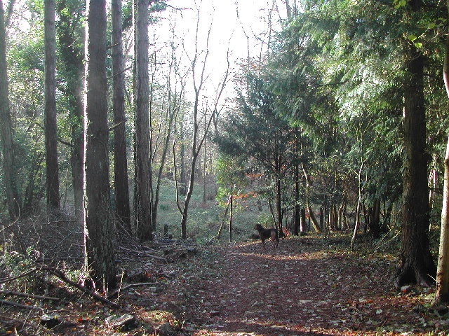
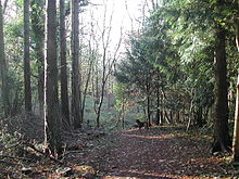 King's Wood
Overlooking the village are several hills and valleys which support a rich diversity of wildlife.
Goblin Combe is a 52 hectares (128 acres) biological Site of Special Scientific Interest (SSSI) originally notified in 1999,[8] with 9 hectares (22 acres) being managed as a nature reserve by the Avon Wildlife Trust.[9] A population of the nationally scarce plant Stinking Hellebore (Helleborus foetidus) grows on scree slopes in the combe, near Cleeve Toot; it is native at this site.[10] Limestone Fern (Gymnocarpum robertianum), another nationally scarce plant, is also found here on limestone scree.[11] Other flowers include the Autumn Gentian, Autumn Ladies'-tresses and Yellow-wort. The site also supports a varied collection of butterflies, with over 30 species recorded. These include Grizzled and Dingy Skippers, Brown Argus and Green Hairstreak.[9]
King's Wood and Urchin Wood SSSI also overlooks the village. It is a 128.1 hectare biological Site of Special Scientific Interest. The site has long been renowned for its botanical interest and records date back to the County Flora of 1893. The woodland supports a particularly high diversity of vascular plants, including populations of the nationally rare plant Purple Gromwell (Lithospermum purpurocaeruleum) and the scarce Angular Solomon’s seal (Polygonatum odoratum).[12] Large areas of King’s Wood were replanted during the 1960s with beech Fagus sylvatica and a variety of conifer species including Douglas fir (Pseudotsuga menziesii), Lawson’s cypress (Chamaecyparis lawsoniana) and Norway spruce (Picea abies) . These crop trees have, however, largely been unsuccessful and the replanted areas are now being overtaken by hardwoods.[12] King’s Wood supports nationally important populations of the rare and endangered greater horseshoe bat (Rhinolophus ferrumequinum) and dormice (Muscardinus avellanarius), and a nationally scarce Chrysomelid beetle (Clytra quadripunctata).[12]
Cleeve Heronry is a heronry in a woodland near the village. 40 nests were counted in 1994. 47 nests in 2007. CCTV from one of the nests can be viewed at Cleeve Nursery in Spring while the birds are raising chicks.[13] An area of 3.2 hectares is owned by Avon Wildlife Trust.
Climate
Along with the rest of South West England, Cleeve has a temperate climate which is generally wetter and milder than the rest of the country.[14] The annual mean temperature is approximately 10 °C (50.0 °F). Seasonal temperature variation is less extreme than most of the United Kingdom because of the adjacent sea temperatures. The summer months of July and August are the warmest with mean daily maxima of approximately 21 °C (69.8 °F). In winter mean minimum temperatures of 1 °C (33.8 °F) or 2 °C (35.6 °F) are common.[14] In the summer the Azores high pressure affects the south-west of England, however convective cloud sometimes forms inland, reducing the number of hours of sunshine. Annual sunshine rates are slightly less than the regional average of 1,600 hours.[14] In December 1998 there were 20 days without sun recorded at Yeovilton. Most the rainfall in the south-west is caused by Atlantic depressions or by convection. Most of the rainfall in autumn and winter is caused by the Atlantic depressions, which is when they are most active. In summer, a large proportion of the rainfall is caused by sun heating the ground leading to convection and to showers and thunderstorms. Average rainfall is around 700 mm (28 in). About 8–15 days of snowfall is typical. November to March have the highest mean wind speeds, and June to August have the lightest winds. The predominant wind direction is from the south-west.[14]
Economy
Many of the residents of Cleeve commute to Bristol for work.[15]
Businesses
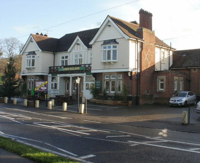
 Lord Nelson public house
The village has a number of businesses including a beauty salon, plant nursery, art gallery, public house,[16] restaurant and two takeaways.
Landmarks
The three-storey Cleeve Court was built in a Gothic style for Rev. T.S. Biddulph in the early 19th century. It has been designated as a Grade II listed building.[17]
Transport
Cleeve is on the A370 road and close to the railway line from Bristol to Weston-super-Mare, with the nearest station being Yatton railway station on a branch of the Bristol to Taunton Line. It provides two trains in each direction each hour. One service shuttles between Bristol Parkway and Weston-super-Mare, calling at most stations via Bristol Temple Meads; the second is the faster Cardiff Central to Taunton service.
The village is 3 miles (5 km) from Bristol International Airport.
Education

The original village school was in the building now used for the Goblin Combe Environment Centre but, in the 1970s, was replaced by the Court De Wyck Church of England Primary School which serves both Cleeve and the neighbouring village of Claverham.[18]
Secondary education is not available in the village so many of Cleeve's children attend Backwell School in the nearby village of Backwell. The school is a specialist Arts College, and includes a sixth form and takes pupils from the age of 11 (Year 7) to the age of 18 (Year 13). The school's original building dates from 1954[19] In 2009, 71% of GCSE students achieved at least five GCSEs above grade C including English and Maths.[20] In November 2008, Backwell School was rated as outstanding by Ofsted.[21]
Religious sites
Cleeve, along with the village of Kenn, was previously part of the parish of Yatton. When the parish was divided public subscriptions were raised to build a separate church from local stone, with the Smyth Pigott family of Brockley Hall in nearby Brockley being the largest contributor. The foundation stone was laid in 1838 and the building consecrated in 1840. Cleeve became a separate parish of Cleeve with Clavenham, in 1843.[22]
The parish Church of Holy Trinity was built in a Neo-Norman style in 1840 by George Phillips Manners and is designated as a Grade II* listed building. Nave, north and south transepts, crossing tower and chancel. The nave has three bays with recessed bays to the north and south and a two-stage tower.[23] In 1888 the church was restored and renovated, and in 1898 stained glass was added to the west windows.[22]
The parish is part of the Diocese of Bath and Wells and in 2005 won an award as the first Ecocongregation in the Diocese.[24]
Sport
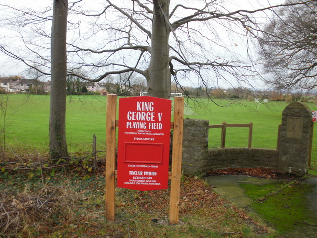
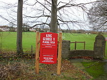 King George V Playing Field sign
At the heart of the village is the King George V Playing Field and Sinclair Pavilion which is home to Cleeve Cricket Club,[25] Cleeve West Town Football Club,[26] and Cleeve Lawn Tennis Club [27] as well as many local skittles teams.
Notable residents
- Cornthwaite Rason (18 June 1858 – 15 March 1927), better known as Hector Rason, was born in the village and later became the seventh Premier of Western Australia.
References
- ^ a b "Parish of Cleeve 2001 Census Parish Information Sheet". 2001 Census Information. North Somerset Council. http://www.n-somerset.gov.uk/NR/rdonlyres/FAD8D2C8-D022-45C6-ADAA-44DCFF18239A/0/census_CleeveParishCensusInfo2001.pdf. Retrieved 2008-10-12.
- ^ "Cleeve Wood, North Somerset". English Heritage ALSF summaries. English Heritage. http://www.english-heritage.org.uk/server/show/ConWebDoc.5397. Retrieved 2008-10-12.
- ^ "Cleeve Toot Settlement". Ancient Settlement in England in Somerset. Megalithic Portal. http://www.megalithic.co.uk/article.php?sid=19485. Retrieved 25 December 2010.
- ^ "Four enclosures on Broadfield Down, North Somerset". North Somerset Historic Environment Record. Yatton, Congresbury, Claverham and Cleeve Archaeological Research Team (YCCCART). http://ycccart.co.uk/Documents/Four%20enclosures%20full%20final.pdf. Retrieved 8 January 2011.
- ^ "Cleeve Toot Camp". Pastscape. English Heritage. http://www.pastscape.org.uk/hob.aspx?hob_id=194816&sort=4&search=all&criteria=Cleeve%20Toot&rational=q&recordsperpage=10. Retrieved 8 January 2011.
- ^ "The Avon (Structural Change) Order 1995". HMSO. http://www.opsi.gov.uk/si/si1995/Uksi_19950493_en_1.htm. Retrieved 2007-12-09.
- ^ A Vision of Britain Through Time : Long Ashton Rural District
- ^ English Nature citation sheet for the site (accessed on 16 July 2006)
- ^ a b "Goblin Combe". Avon Wildlife Trust. http://www.avonwildlifetrust.org.uk/reserves/goblin_combe.htm. Retrieved 8 January 2011.
- ^ Myles, Sarah. (2000). The Flora of the Bristol Region. p. 64. ISBN 1-874357-18-8.
- ^ Myles, Sarah. (2000). The Flora of the Bristol Region, p. 59. ISBN 1-874357-18-8.
- ^ a b c English Nature citation sheet for the site . Retrieved 19 July 2006.
- ^ "Heron Cam". Cleeve Nursery. http://www.cleevenursery.co.uk/index.php?option=com_content&task=view&id=21&Itemid=50. Retrieved 2008-01-26.
- ^ a b c d "South West England: climate". Met Office. http://www.metoffice.gov.uk/climate/uk/sw/. Retrieved 14 March 2010.
- ^ "Council call for reduced speed limit". This is Bristol. http://www.thisisbristol.co.uk/news/Council-reduced-speed-limit/article-2608045-detail/article.html. Retrieved 10 January 2011.
- ^ "Lord Nelson". British Pub Guide. SDS Publishing Limited. http://www.britishpubguide.com/cgi-bin/pub.cgi?results:Somerset:652. Retrieved 2011-01-07.
- ^ "Cleeve Court". Images of England. English Heritage. http://www.imagesofengland.org.uk/Details/Default.aspx?id=33683. Retrieved 2008-10-12.
- ^ "Court De Wyck School". Court De Wyck School. http://www.courtdewyck.co.uk/. Retrieved 2008-10-23.
- ^ "Planning committee meeting minutes". North Somerset Council. 11 November 2001. http://www.n-somerset.gov.uk/cairo/docs/doc9016.htm. Retrieved 2007-05-30.
- ^ "Backwell School". Education League Tables. BBC News Education. 13 January 2010. http://news.bbc.co.uk/1/shared/bsp/hi/education/09/school_tables/secondary_schools/html/802_4129.stm. Retrieved 7 April 2010.
- ^ "Inspection Report". Ofsted. 20 November 2008. http://ofsted.gov.uk/oxedu_reports/display/(id)/102753. Retrieved 6 March 2009.
- ^ a b "A short history of the Church at Cleeve". Yatton Moor Team Ministry. http://www.yattonchurches.org/cleeve/cleeve_history.html. Retrieved 8 January 2011.
- ^ "Church of Holy Trinity". Images of England. English Heritage. http://www.imagesofengland.org.uk/Details/Default.aspx?id=33686. Retrieved 2008-10-12.
- ^ "Holy Trinity, Cleeve wins Green Church of the Year 2007". Court de Wyck Church of England Primary School. http://www.court-de-wyck.n-somerset.sch.uk/church_links.htm. Retrieved 8 January 2011.
- ^ "Cleeve Cricket Club". Cleeve Cricket Club. http://www.cleevecc.co.uk. Retrieved 2008-10-12.
- ^ "Cleeve West Town Football Club". Clubwebsite. http://www.clubwebsite.co.uk/cleevewesttownfc/. Retrieved 2008-10-12.
- ^ "Cleeve Tennis Club". Lawn Tennis Association. http://www2.lta.org.uk/Search/FindAClub/ViewDetails.htm?Id=1-60XGR&BSMGuid=a3592f35-a18a-4c4a-93b4-3b1ccda6a709. Retrieved 2008-10-12.
External links
Categories:- Civil parishes in Somerset
- Villages in North Somerset

Wikimedia Foundation. 2010.