- Yatton
-
- See also: Yatton, Herefordshire
Coordinates: 51°23′08″N 2°49′32″W / 51.3855°N 2.8256°W
Yatton 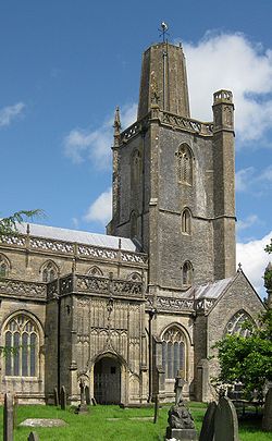
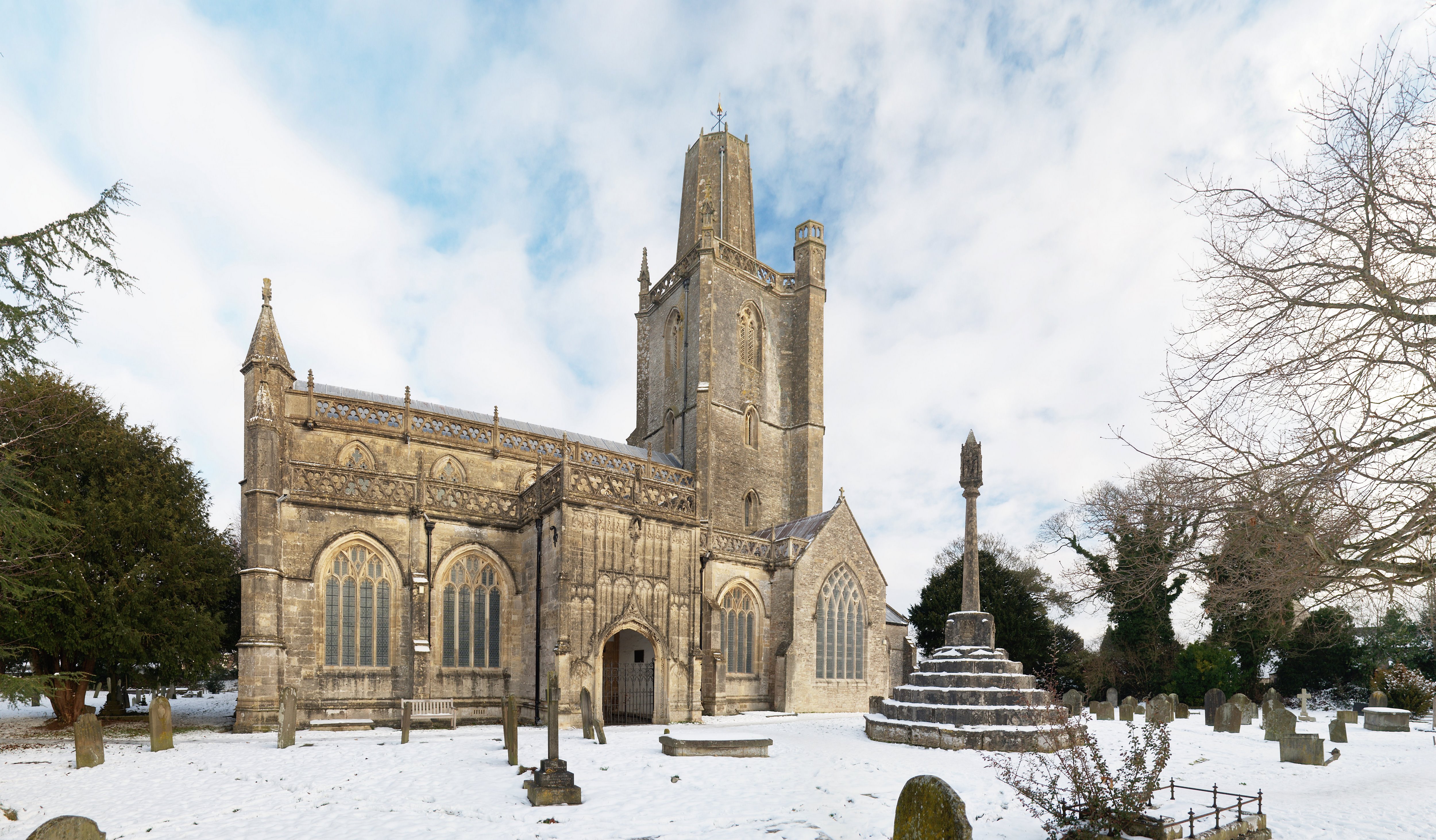
Church of St Mary, Yatton
 Yatton
Yatton shown within SomersetPopulation 9,176 [1] OS grid reference ST425655 Unitary authority North Somerset Ceremonial county Somerset Region South West Country England Sovereign state United Kingdom Post town BRISTOL Postcode district BS49 Dialling code 01934 Police Avon and Somerset Fire Avon Ambulance Great Western EU Parliament South West England UK Parliament North Somerset List of places: UK • England • Somerset Yatton is a village and civil parish within the unitary authority of North Somerset, which falls within the ceremonial county of Somerset, England. It is located 11 miles (18 km) south-west of Bristol. Its population in 2001 was 9,176.[1] The parish includes Claverham, a small village which was originally a farming hamlet.
The origins of the village and its name are unclear, however there is evidence of Iron Age hill fort and a Roman villa in the area. The arrival of the railway in the 19th century and more recent road building have led to expansion of the village with Yatton now acting as a home to many commuters, while also supporting manufacturing industry and commerce. The village is located on the North Somerset Levels, where the low lying land, a mixture of peat, estuarine alluvium and low hills of sand and gravel, is crossed by a myriad of watercourses, providing a habitat for several scarce species.
St Mary's Church, dates from the fourteenth century and there are a range of other places of worship. In addition to religious groups Yatton has several sporting clubs and other community groups.
Contents
History
Toponymy
The origin of the name Yatton is uncertain. It may come from the Anglo-Saxon 'gatton' meaning 'village on the track'; the track in question is a path of limestone leading from Cadbury Hill.[2] The village has at one time or another been called Jatune, Eaton (from ea (river) and tun i.e. the settlement on the River Yeo and Yatton Blewitt, and is recorded as Lature in the Domesday Book.[3]
Pre-history
Situated on an area of slightly higher, drained ground surrounded by moorland (locally called a 'batch'), Yatton was a well-established village by Norman times.[2] The remains of an Iron Age hill fort at Cadbury Hill have been discovered,[4] as well as a Roman villa, temple and hoard of coins.[5] Older Christian burial grounds have also been discovered on Cadbury Hill.[6]
The parish was part of the Winterstoke Hundred.[7]
Railway
Main article: Yatton railway station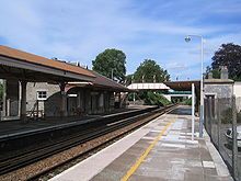 Yatton railway station
In 1840s The Bristol & Exeter Railway, with Isambard Kingdom Brunel as consulting engineer, was opened. It was initially leased to the Great Western Railway but taken back into full ownership in 1849 and gained its own individuality which lasted until 1876 when all the Broad Gauge companies in the West Country merged into an enlarged GWR. The station was originally called Clevedon Road and renamed Yatton Junction when the Clevedon branch was built in 1847. Other branches followed, to Cheddar/Wells (1869)] and the Wrington Vale Light Railway (1901) to Blagdon from Congresbury. Although the branch line to Blagdon was closed to passengers in 1932, and the Clevedon and Cheddar/Wells lines were closed during the 1960s, the classically Victorian station designed by Brunel is still in use. From 2001 to 2006 the station was operated by Wessex Trains when, in an echo of 1876, it was again absorbed into the new Greater Western Trains Co. [8] It is now possible to walk or cycle along the former route of the Strawberry Line (so called because of the trade in Cheddar's strawberries) from Yatton to Cheddar. A local group successfully raised funding to establish a community cafe in the old waiting room building at the Station, and the cafe opened for business in December 2010.[9]
20th century
In 1922 the site formerly known as 'The Pound' was purchased and the Yatton Parish War Memorial was erected. The memorial is located at Top Scaur, at the Congresbury end of the High Street, and is inscribed with the names of Yatton villagers who died in the First World War and Second World War.[10] Each year on Remembrance Sunday a march is held from St Mary's Church to the memorial, where wreaths are laid by villagers and local organisations.
The village has continued to increase in size with several new developments planned or currently being constructed north of the railway station near North End Road and Arnold's Way. Development to the south and east of the village has made the villages of Yatton, Claverham and Cleeve almost continuous as far as the A370. Cadbury House Country Club is being developed to become a 60-room hotel and leisure centre.[11]
The hamlet of North End lies to the north of the Arnold's Way roundabout, just before the junction for Kingston Seymour, and contains between 15 and 20 properties, including a number of farms and the Bridge Inn hotel.[12]
Governance
The parish council, which has 18 members,[13] has responsibility for local issues, including setting an annual precept (local rate) to cover the council’s operating costs and producing annual accounts for public scrutiny. The parish council evaluates local planning applications and works with the local police, district council officers, and neighbourhood watch groups on matters of crime, security, and traffic. The parish council's role also includes initiating projects for the maintenance and repair of parish facilities, such as the village hall or community centre, playing fields and playgrounds, as well as consulting with the district council on the maintenance, repair, and improvement of highways, drainage, footpaths, public transport, and street cleaning. Conservation matters (including trees and listed buildings) and environmental issues are also of interest to the council.
The parish falls within the unitary authority of North Somerset which was created in 1996, as established by the Local Government Act 1992. It provides a single tier of local government with responsibility for almost all local government functions within its area including local planning and building control, local roads, council housing, environmental health, markets and fairs, refuse collection, recycling, cemeteries, crematoria, leisure services, parks, and tourism. It is also responsible for education, social services, libraries, main roads, public transport, trading standards, waste disposal and strategic planning, although fire, police and ambulance services are provided jointly with other authorities through the Avon Fire and Rescue Service, Avon and Somerset Constabulary and the Great Western Ambulance Service.
North Somerset's area covers part of the ceremonial county of Somerset but it is administered independently of the non-metropolitan county. Its administrative headquarters is in the town hall in Weston-super-Mare. Between 1 April 1974 and 1 April 1996, it was the Woodspring district of the county of Avon.[14] Before 1974 that the parish was part of the Long Ashton Rural District.[15]
The parish is represented in the House of Commons of the Parliament of the United Kingdom as part of the North Somerset. It elects one Member of Parliament (MP) by the first past the post system of election. It is also part of the South West England constituency of the European Parliament which elects seven MEPs using the d'Hondt method of party-list proportional representation.
Geography
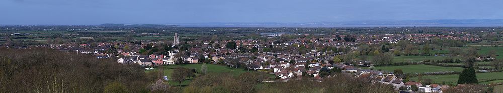 Panoramic view of Yatton from Cadbury Hill. In the distance on the left are Flat Holm, Sand Point and Woodspring Priory. The Church of St Mary is the most prominent landmark in Yatton; in the distance one can see the Church of All Saints in Kingston Seymour. On the other side of the Severn Estuary are the South Wales coast and Cardiff. The panorama is bisected by the M5 motorway and the Great Western Railway
The area around Yatton and Claverham, which falls within the North Somerset Levels, is a mixture of peat, estuarine alluvium and low hills of sand and gravel with, to the south the limestone ridge of Cadbury Hill, which rises to 250 feet (76 m).[16] On its summit stands an Iron Age hill fort known, in archaeological circles, as Cadbury-Congresbury in order to differentiate it from the Cadbury hillfort in South Cadbury. It appears to have been constructed in the Iron Age when one or more ramparts, with walls and ditches, were built on the steep slopes of the hill to defend an area covering some 8.5 acres (34,000 m2).[17]
Biddle Street, Yatton has been designated as a Site of Special Scientific Interest where management practices and the variation in the soils has resulted in the watercourses supporting a wide range of aquatic plant communities. Where open water occurs plants such as Common Water-starwort (Callitriche stagnalis), European Frogbit (Hydrocharis morsusranae), Fan-leaved Water-crowfoot (Ranunculus circinatus). The calcareous influence of the underlying Compton soils also encourages Whorled Water-milfoil (Myriophyllum verticillatum) and Stonewort (Chara sp). Also present are the nationally scarce Rootless Duckweed (Wolffia arrhiza) and Hairlike Pondweed (Potamogeton trichoides).[18]
Along with the rest of South West England, Yatton has a temperate climate generally wetter and milder than the rest of England. The annual mean temperature is about 10 °C (50 °F) with seasonal and diurnal variations, but the modifying effect of the sea restricts the range to less than that in most other parts of the United Kingdom. January is the coldest month with mean minimum temperatures between 1 °C (34 °F) and 2 °C (36 °F). July and August are the warmest, with mean daily maxima around 21 °C (70 °F).[19] In general, December is the dullest month and June the sunniest. The south-west of England enjoys a favoured location, particularly in summer, when the Azores High extends its influence north-eastwards towards the UK.[20]
Cloud often forms inland, especially near hills, and reduces exposure to sunshine. The average annual sunshine is about 1,600 hours. Rainfall tends to be associated with Atlantic depressions or with convection. In summer, convection caused by solar surface heating sometimes forms shower clouds and a large proportion of the annual precipitation falls from showers and thunderstorms at this time of year. Average rainfall is around 800–900 mm (31–35 in). About 8–15 days of snowfall is typical. November to March have the highest mean wind speeds, with June to August having the lightest; the prevailing wind direction is from the south-west.[19][21]
Demography
After the Second World War the size and population of Yatton expanded dramatically. With a railway providing good access to Weston-super-Mare, Bristol and London, and similarly good access by road, the village saw large amounts of new housing development. Today the number of pre-war buildings is much smaller than the number of more recent residential and commercial constructions. According to the 2001 census, Yatton's population was 9,176.[1]
Economy
 Page's Court, known locally as 'The Precinct'
Today Yatton is a large village. Page's Court — the village's shopping precinct contains a bank, supermarket and several local shops.
There are a number of thriving local businesses, including Simulation Systems Ltd,[22] Stowell Concrete,[23] Smart Systems,[24] Oxford Instruments,[25] Titan Ladders[26] and Bob Martin Petcare.[27] Farming remains an important activity in the area.
Education
The local education authority is North Somerset Council. Yatton has a pre-school,[28] infant[29] and junior schools.[30]
Secondary education is not available in the village, and so many of Yatton's children commute daily to the nearby village of Backwell in order to attend Backwell School. The school is a specialist Arts College, and includes a sixth form and takes pupils from the age of 11 (Year 7) to the age of 18 (Year 13). In November 2008, Backwell School was rated as outstanding by Ofsted.[31]
Religious sites
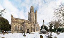 The south side of St Mary's church
St Mary's Church, in central Yatton, built around 1400,[32] is often called the "Cathedral of the Moors" since it is so large compared to the village. The tower has three stages with diagonal weathered buttresses with crocketed pinnacles. There is a south-east hexagonal stair turret rising above the parapet with panelled sides to the top, and an open cusped parapet. There are stained glass windows with the coats of arms of local lords of the manor.[33] It has been designated by English Heritage as a Grade I listed building.[34] The Old Rectory was a Prebendary house, built in the 15th century and has been designated as a Grade I listed building.[35]
As well as St Mary's (Church of England), Yatton has Methodist, Catholic and independent places of worship. Yatton Methodist Church is situated on the High Street, opposite the main shopping precinct.[36] Horsecastle Chapel, an independent evangelical church, is on Horsecastle Farm Road. River of Life Church, (was YCF) affiliated to the Assemblies of God, meets in Yatton Infant School.[37] St Dunstan's, a Roman Catholic chapel of ease to the parish in Clevedon, is on Claverham Road.[38]
The Church of St. Barnabas in Claverham, dates from 1879 and is a grade II listed building.[39] Along with churches in Kenn, Somerset, Cleeve and Kingston Seymour the churches are managed as part of the Yatton Moor Team Ministry.[40]
Sports
There are active cricket, football and rugby clubs, two parks (Hangstones and Rock Road), a number of public houses, and many other leisure and sporting activities, including the Cleeve Claverham and Yatton Scout Group.[41]
Yatton Rugby Club was founded in 1968 and plays in Tribute South West 2 West League. They run three senior sides and have an extensive junior set-up.[42]
Claverham (Yatton) Cricket Club was formed in 1905 and provides cricket to all playing levels and ages. 2010 will see the 1st & 2nd XI's play in the ECB West of England Premier League, Bristol and North Somerset Division. The 3rd XI will compete in the North Somerset Sunday Conference Division 3 following their promotion in 2009.[43]
Public services
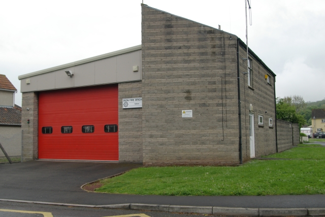
 Fire station
Yatton fire station opened in 1947, after the Fire Services Act 1947, when fire service responsibility transferred from national government to local authority control after World War II. The current station was built in 1973. Today, Yatton fire station, which is part of Avon Fire and Rescue Service, runs with two appliances, a water tender ladder and a specialist hose-laying vehicle.[44]
The Yatton firefighters work on a retained duty system, which means that they do not work at the fire station, but are called to the station when a fire breaks out.[45] They respond to emergencies in a 62 square miles (161 km2) area covering Yatton, Cleeve, Kingston Seymour, Congresbury, and Wrington, with an average of 130-150 callouts per year. Calls vary from small grass fires to full major alerts and road traffic accidents on the busy A370 main road.[44] The Avon Fire and Resuce Service named Yatton Fire Station was named "highest performing retained duty station" for 2010.[46]
Notable people
George Lukins, also known as the Yatton dœmoniac,[47][48][49] was an individual famous for his alleged demonic possession and the subsequent exorcism that occurred in 1788.[50] Ken Day was born in Yatton in 1919 and played first-class cricket for Somerset County Cricket Club in seven matches between 1950 and 1956.[51]
References
- ^ a b c "2001 Census Ward Information Sheet: Yatton" (PDF). North Somerset Council. http://www.n-somerset.gov.uk/NR/rdonlyres/F6069DAE-939E-4C6F-B357-B52631F07DBB/0/census_YattonCensusWardInfo2001.pdf. Retrieved 23 December 2007.
- ^ a b "History of Yatton and its Ancient Parish Church". Yatton Moor Team Ministry. http://www.yattonchurches.org/yatton/yatton_history.html. Retrieved 13 November 2010.
- ^ Robinson, Stephen (1992). Somerset Place Names. Wimborne, Dorset: Dovecote Press. ISBN 1874336032.
- ^ Alcock, Leslie (1971). Arthur's Britain. London: Allen Lane: The Penguin Press. ISBN 0-7139-0245-0.
- ^ Scarth, Harry. "Roman burial at Cadbury Hill, near Yatton". Wrington online. http://www.wringtonsomerset.org.uk/history/roman/scarth.html. Retrieved 12 June 2010.
- ^ "Yatton and Cadbury Hillfort Circular". Bristol City Council. http://www.bristol.gov.uk/ccm/cms-service/download/asset/?asset_id=32656203. Retrieved 12 June 2010.
- ^ "Somerset Hundreds". GENUKI. http://www.genuki.org.uk/big/eng/SOM/Miscellaneous/. Retrieved 9 September 2011.
- ^ "Yatton Station Buildings and Footbridge". Images of England. English Heritage. http://www.imagesofengland.org.uk/details/default.aspx?id=33851. Retrieved 19 November 2007.
- ^ "FAQ". Strawberry Line Cafe Project. http://www.strawberrylinecafe.co.uk/. Retrieved 12 June 2010.
- ^ "War memorial". British Listed Buildings. http://www.britishlistedbuildings.co.uk/en-505183-war-memorial-yatton. Retrieved 12 June 2010.
- ^ "Cadbury House Hotel". Doubletree by Hilton. http://www.cadburyhotelbristol.co.uk/. Retrieved 12 June 2010.
- ^ "Bridge Inn". Bridge Inn. http://www.bridgeinn-yatton.co.uk/index.php. Retrieved 13 November 2010.
- ^ "About Yatton Parish Council". Yatton Parish Council. http://www.yatton-pc.gov.uk/Core/Yatton-Parish-Council/Pages/About_Yatton_Parish_Council_2.aspx. Retrieved 12 June 2010.
- ^ "The Avon (Structural Change) Order 1995". HMSO. http://www.opsi.gov.uk/si/si1995/Uksi_19950493_en_1.htm. Retrieved 9 December 2007.
- ^ "Long Ashton Rural District". A Vision of Britain Through Time. University of Portsmouth. http://www.visionofbritain.org.uk/relationships.jsp?u_id=10107763&c_id=10001043. Retrieved 12 June 2010.
- ^ "History". All about Claverham. http://claverham.imagine-it.co.uk/more02.asp. Retrieved 12 June 2010.
- ^ Payne, Andrew; Corney, Mark; Cunliffe, Barry (2007). "The Wessex Hillforts Project: Extensive Survey of Hillfort Interiors in Central Southern England". English Heritage. p. 1. ISBN 978-1873592854. http://www.english-heritage.org.uk/server/show/ConWebDoc.10744.
- ^ "SSSI citation sheet for Biddle Street". English Nature. http://www.english-nature.org.uk/citation/citation_photo/1006788.pdf. Retrieved 12 June 2010.
- ^ a b "South West England: climate". Met Office. http://www.metoffice.gov.uk/climate/uk/sw/. Retrieved 14 March 2010.
- ^ "The Azores High". WeatherOnline Weather facts. http://www.weatheronline.co.uk/reports/wxfacts/The-Azores-High.htm. Retrieved 19 November 2006.
- ^ "About south-west England". Met Office. Archived from the original on 15 January 2008. http://web.archive.org/web/20080115200917/http://www.metoffice.com/climate/uk/location/southwestengland/index.html. Retrieved 21 June 2006.
- ^ "A Brief History of SSL". Simulation Systems Ltd (SSL). http://www.simulation-systems.co.uk/Brief_History_of_SSL.php. Retrieved 12 June 2010.
- ^ "Our works". Stowell Concrete. http://www.stowellconcrete.co.uk/works.php. Retrieved 12 June 2010.
- ^ "About us". Smart architectural aluminium. http://www.smartsystems.co.uk/content/1/18/about-us.html. Retrieved 12 June 2010.
- ^ "Plasma Technology UK". Oxford Instruments. http://www.oxford-instruments.com/contacts/etchdep/Pages/etching-deposition-growth-contacts.aspx. Retrieved 12 June 2010.
- ^ "Titan Ladders". Titan Ladders. http://www.titanladders.co.uk/PAGES/home.html. Retrieved 12 June 2010.
- ^ "Contact us". Bob Martin. http://www.bobmartin.co.uk/contactus.html. Retrieved 12 June 2010.
- ^ "St Mary's Pre-School". St Mary's Pre-School. http://www.stmaryschurchpreschool.org.uk/. Retrieved 12 June 2010.
- ^ "Yatton Infant School". Yatton Infant School. http://www.yattonvc-inf.n-somerset.sch.uk/. Retrieved 12 June 2010.
- ^ "Yatton Church of England Junior School". Inspection Reports. Office for Standards in Education, Children’s Services and Skills. http://www.ofsted.gov.uk/oxedu_providers/full/%28urn%29/109214/%28type%29/4096/%28typename%29/Primary%20schools. Retrieved 12 April 2011.
- ^ "Inspection Report". Ofsted. 20 November 2008. http://ofsted.gov.uk/oxedu_reports/display/(id)/102753. Retrieved 6 March 2009.
- ^ Poyntz Wright, Peter (1981). The Parish Church Towers of Somerset, Their construction, craftsmanship and chronology 1350 - 1550. Avebury Publishing Company. ISBN 0861275020.
- ^ Deas, Nicholas, A.. "Yatton armorial glass". Extracts from SANHS Proceedings. http://www.sanhs.org/Proc%20Yatton.htm. Retrieved 12 June 2010.
- ^ "Church of St Mary". Images of England. English Heritage. http://www.imagesofengland.org.uk/details/default.aspx?id=33810. Retrieved 19 November 2007.
- ^ "The Old Rectory". Images of England. English Heritage. http://www.imagesofengland.org.uk/Details/Default.aspx?id=33808. Retrieved 9 April 2009.
- ^ "Yatton Methodist Church". Yatton Methodist Church. http://www.yatton-methodist.org.uk. Retrieved 6 July 2009.
- ^ "River of Life Church". River of Life Church. http://www.rolchurch.co.uk/. Retrieved 6 July 2009.
- ^ "Yatton Methodist Church". Yatton Methodist Church. http://www.clevedon.friary.info/. Retrieved 6 July 2009.
- ^ "Church of St. Barnabas". Images of England. English Heritage. http://www.imagesofengland.org.uk/details/default.aspx?id=33828. Retrieved 4 December 2006.
- ^ "Yatton Moor Team Ministry". Yatton Moor Team Ministry. http://www.yattonchurches.org/index.html. Retrieved 12 June 2010.
- ^ "Cleeve Claverham and Yatton Scout Group". Cleeve Claverham and Yatton Scout Group. http://www.ccyscoutgroup.org.uk/. Retrieved 12 June 2010.
- ^ "Yatton Rugby Club". Yatton Rugby Club. http://www.yattonrugby.co.uk. Retrieved 6 August 2008.
- ^ "Claverham (Yatton) Cricket Club". England and Wales Cricket Board. http://claverham.play-cricket.com/home/home.asp. Retrieved 12 June 2010.
- ^ a b "Yatton". Avon Fire and Rescue Service. http://www.avonfire.gov.uk/Avon/Your+local+station/19+Yatton/. Retrieved 12 June 2010.
- ^ "About Us". Avon Fire & Rescue Service. http://www.avonfire.gov.uk/Avon/About+us/. Retrieved 13 April 2011.
- ^ Evening Post (accessed via thisisBristol.co.uk). 21 December 2010. http://www.thisisbristol.co.uk/news/hot-safety-education/article-3026473-detail/article.html. Retrieved 12 April 2011.
- ^ Authentic anecdotes of George Lukins, the Yatton dœmoniac. G. Routh. 1788. http://books.google.com/books?id=T-2-QAAACAAJ&dq=george+lukins&cd=8. Retrieved 31 December 2007.
- ^ Easterbrook, Joseph; Lukins, George (1788). An appeal to the public respecting G. Lukins, (called the Yatton Demoniac) containing an account of his affliction and deliverance, etc.. http://books.google.com/?id=tAw0HAAACAAJ&dq=george+lukins&cd=20. Retrieved 31 December 2007.
- ^ Patients and practioners. Cambridge University Press. 13 February 2003. ISBN 9780521530613. http://books.google.com/?id=SZ5Bubh1MzsC&pg=PA159&dq=George+Lukins&cd=21#v=onepage&q=George%20Lukins. Retrieved 31 December 2007.
- ^ Bulletin of the John Rylands University Library of Manchester, Volume 85, Issues 2-3. John Rylands Library - University of Manchester. 2005. http://books.google.com/?id=QyUoAQAAIAAJ&q=George+Lukins&dq=George+Lukins&cd=36. Retrieved 31 December 2007.
- ^ "Ken Day". Cricket Archive. http://www.cricketarchive.com/Archive/Players/3/3515/3515.html. Retrieved 12 June 2010.
External links
- Yatton at the Open Directory Project
The North Somerset Levels Categories:- Villages in North Somerset
- Civil parishes in Somerset


Wikimedia Foundation. 2010.