- Cheddar Valley Line
-
Cheddar Valley line Legend


Yatton, GWR (From Taunton to Bristol) 

Congresbury (Interchange) 


Wrington Vale Light Railway 
Sandford and Banwell Winscombe Axbridge Cheddar Draycott Lodge Hill (Serving Westbury-sub-Mendip) Wookey Wells (Tucker Street) (Opened in 1870) 

Somerset and Dorset Joint Railway (To Glastonbury) Wells (Priory Road) 
(Interchange from 1934, closed 1951, opened in 1862) 
East Somerset Railway (All stations between Wells and Witham) 

Witham (Somerset), GWR (Heart of Wessex Line from Weymouth to Bristol) The Cheddar Valley line was a railway line in Somerset, England, opened in 1869 and closed in 1963. It became known as The Strawberry Line because of the volume of locally-grown strawberries that it carried.
It ran from Yatton railway station through Cheddar to Wells (Tucker Street) railway station. Here it joined the East Somerset Railway to make a through route via Shepton Mallet (High Street) railway station to Witham. Sections of the now-disused railway have been opened as the Strawberry Line Trail, which currently runs from Yatton to Cheddar.
Contents
History
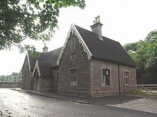 Former Axbridge railway station in the decorative style used for most of the line's stations
In the middle of the 19th century there were a large number of railway companies operating and this, in part, led to the line being built in several sections. The first section built was the East Somerset Railway from Witham to Shepton Mallet, opening on 9 November 1858. The line was extended to Wells, opening on 1 March 1862. This extended line was bought by the Great Western Railway (GWR) in 1874.
Meanwhile, Yatton was under the control of the Bristol and Exeter Railway, which opened the branch through to Cheddar on 3 August 1869,[1] although the station had existed since 1841.[2] This was extended to Wells on 5 April 1870, with the opening of the Tucker Street station, but the link through to the East Somerset line from Witham was not completed until 1878, and involved passing through a third Wells station, Wells (Priory Road) and using a section of track owned and operated by the Somerset and Dorset Joint Railway. The S&DJR was already standard gauge by this time, and the other two railways had moved from broad gauge to standard gauge in 1875. The Bristol and Exeter was acquired by the GWR in 1876, and the integrated service ran from Yatton through to Witham, which became the standard service for this line from 1878. The line was single-track for most of the journey between Yatton and Wells, apart from the junction at Congresbury. At Wells, trains ran through the Priory Road S&DJR station without stopping until 1934, and that station remained open as the terminus of the short branch line from Glastonbury and Street until the branch closure in 1951 left Tucker Street as the last remaining Wells station.[3]
The prime motivation for the line to Cheddar and Draycott was to provide transport for strawberries, and Cheddar cheese. This led to its nickname the Strawberry Line. The pub opposite the station in Draycott is now called The Strawberry Special.
On 4 December 1901, the Wrington Vale Light Railway opened a branch from Congresbury to Blagdon. This survived until 14 September 1931 for passenger traffic, and 1 November 1950 for goods traffic.
The Cheddar Valley line survived until the "Beeching Axe". Towards the end of its life, there were so few passengers that diesel railcars were sometimes used. The Cheddar branch closed to passengers on 9 September 1963 and to goods in 1964.[4] The line closed in the 1960s, when it became part of the Cheddar Valley Railway Nature Reserve.[5]
Strawberry Line trail
The disused line between Yatton and Cheddar today forms The Strawberry Line, a railway walk and part of the National Cycle Network route 26.
The trail starts at Yatton railway station and is in good condition most of the way to the site of Congresbury railway station, although it is necessary to follow a farm track near Congresbury as the railway bridge over the Congresbury Yeo river has been demolished. The platforms of the former station here remain, as do houses built for railway workers. Although the platforms are currently covered in vegetation and in need of repair due to root damage, the track bed between platforms is clear of undergrowth and as of July 2008 has been levelled with a fine gravel surface applied.
The route to Sandford continues with wide quality surfacing, although currently lacking in seats with none for over 3 miles (5 km). Upon reaching the rail bridge on the outskirts of Sandford the trail joins Nye Road (a country lane) for approximately 0.44 miles (1 km), before turning right into the new (June 2009) off-road link. To avoid travelling along the A368, the link passes next to orchards and crosses a large field before rejoining the track bed for a short stretch to the A368. After crossing the road the site of Sandford & Banwell station becomes visible. The grade II listed buildings,[6] and platform were preserved by the original owners Sandford Stone, the site has since been redeveloped as "Sandford Station Retirement Village" a sheltered housing complex. The route goes around the perimeter with a view of the station, goods shed and platform including a short section of track complete with period carriage and open wagons. The station is now restored and open to the public on summer weekends with access from the trail.
The scenery through to Winscombe changes from open moorland to railway cuttings, with the path in condition to match the previous sections. Upon reaching the site of the former station now being the villages Millennium Green the platform is preserved, and a time line of local and world events inserted along its length. The small red bricked facade of the demolished station building has been laid flat into is former foundation, and the layout of rooms can still be seen. Seats and lighting have been provided with public toilets also available to the rear of the platform at street level.
After Winscombe the line continues to Shute Shelve Tunnel, the surface through has been tarmaced but unlit except for a central guide line of small solar powered "cat's eyes" automatically switched on by pedestrians or cyclists entering the tunnel. It passes under the Mendip Way and a narrow point in the Mendip Hills. From this point eastwards the line follows the southern edge of the Mendips crossing the Cheddar Yeo. The track bed around Axbridge is now the A371 bypass, but the station building, goods shed and station master's house are all in use for various purposes. The Strawberry Line Trail goes through the town itself missing out the station site higher on the hillside behind the church.
The railway track is regained opposite St Michael's Cheshire Home and is in good condition through to Cheddar, with a picnic spot overlooking the reservoir. The route comes to an end at the side of the former station now in use as a stonemason's surrounded by a small industrial estate, just 1 mile (2 km) from Cheddar Gorge.
A roadsign in Draycott still bears the legend "Draycott Station 1/4 mile" (although the embossed letters are now painted over), and there are tunnels currently used as a bridges in Draycott and neighbouring Rodney Stoke
The nature reserve which is based around the old railway line has been reclaimed by nature. Habitats include dense scrub, which encourages birds and bats. Areas of rough grass are occupied by amphibians and reptiles, and grass snakes or slow worms can be seen basking in the sun.[7] It also includes parts of the Biddle Street Site of Special Scientific Interest.
Future plans
Plans to extend the route along the line from Cheddar all the way to Wells were published on the 28th May 2009,[8] in places the old railway has been built on but the plan is to follow the line as closely as possible. The "Safe Paths for All" campaign also aims to extend the route from Wells to Shepton Mallet and Cranmore by 2012.[9]
At the other end of the route a feasibility study has been undertaken by North Somerset Council, which would see an extension from Yatton to Clevedon along the former Clevedon branch line.[10] Again parts of the line have been built on and station buildings at Clevedon no longer exist.
A footbridge over the Congresbury Yeo in place of the long demolished rail bridge is also planned.[11]
Features
Point Coordinates
(links to map & photo sources)Notes Yatton railway station 51°23′28″N 2°49′40″W / 51.391°N 2.8278°W Start of railway line Congresbury railway station 51°22′00″N 2°49′00″W / 51.3667°N 2.8167°W Platforms remain Sandford and Banwell railway station 51°19′55″N 2°50′22″W / 51.332029°N 2.839327°W Restored, heritage centre open summer weekends Winscombe railway station 51°18′55″N 2°50′07″W / 51.315244°N 2.835159°W Now the village's "Millenium Green" Shute Shelve tunnel north portal 51°18′07″N 2°49′51″W / 51.302049°N 2.830814°W Tunnel under a narrow point in the Mendip Hills Shute Shelve tunnel south portal 51°18′01″N 2°49′51″W / 51.300291°N 2.830806°W Axbridge railway station 51°17′18″N 2°48′59″W / 51.288349°N 2.816319°W Now a community centre Cheddar railway station 51°16′32″N 2°47′02″W / 51.27562°N 2.783929°W Some buildings now used by Wells Cathedral Stonemasons Draycott railway station 51°15′10″N 2°45′17″W / 51.25279°N 2.754661°W Lodge Hill railway station 51°13′59″N 2°43′10″W / 51.232923°N 2.71946°W The trackbed was formerly Westbury-sub-Mendip airfield Wookey railway station 51°12′51″N 2°40′21″W / 51.21423°N 2.672499°W Wells (Tucker Street) railway station 51°12′24″N 2°39′19″W / 51.206752°N 2.655371°W Now covered by the city centre bypass Wells (Priory Road) railway station 51°12′15″N 2°39′11″W / 51.204161°N 2.65301°W References
- ^ "Cheddar Valley and Yatton Railway". RAILSCOT. http://www.railscot.co.uk/Cheddar_Valley_and_Yatton_Railway/frame.htm. Retrieved 2007-11-23.
- ^ "Yatton". Bristol Railway Archive. http://bristol-rail.co.uk/wiki/Yatton. Retrieved 9 October 2010.
- ^ Mike Oakley. Somerset Railway Stations (2002 ed.). Dovecote Press, Wimborne. p. 125.
- ^ Gerald Daniels and L.A.Dench. Passengers No More (1974 ed.). Ian Allan. p. 16.
- ^ "Strawberry Line". Forest of Avon. http://www.forestofavon.org/sl.html. Retrieved 2007-11-23.
- ^ "Former Sandford Station". Images of England. http://www.imagesofengland.org.uk/details/default.aspx?pid=2&id=33291. Retrieved 10 May 2011.
- ^ "Cheddar Valley Railway Walk". Natural England. http://www.english-nature.org.uk/special/lnr/lnr_details.asp?C=1&ID=1246&N=. Retrieved 2007-11-23.
- ^ "Wells to Cheddar Planning Application". The Strawberry Line official website. http://www.thestrawberryline.co.uk/d/164/Planning_Application.html. Retrieved 2009-06-25.
- ^ "Aims". The Strawberry Line official website. http://www.thestrawberryline.co.uk/d/54/Aims.html. Retrieved 2008-08-29.
- ^ "The Clevedon to Yatton Route". The Strawberry Line official website. http://www.thestrawberryline.co.uk/index.php?doc=146&rev=146. Retrieved 2009-06-25.
- ^ "Cheddar Valley Railway Walk Society". Cheddar Valley Railway Walk Society. http://www.cheddarvalleywalk.org.uk/. Retrieved 2007-11-23.
External links
Categories:- Rail transport in Somerset
- Closed railway lines in South West England
- Rail trails in England
- Railway lines opened in 1869
- Railway lines closed in 1963
- Great Western Railway constituents
- 7ft gauge railways
- Standard gauge railways in England


Wikimedia Foundation. 2010.