- Cheddar Wood
-
Cheddar Wood Site of Special Scientific Interest 
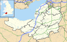
Area of Search Somerset Grid reference ST445552 Coordinates 51°17′36″N 2°47′50″W / 51.29321°N 2.79733°WCoordinates: 51°17′36″N 2°47′50″W / 51.29321°N 2.79733°W Interest Biological Area 86.9 hectares (0.869 km2; 0.336 sq mi) Notification 1967 Natural England website Cheddar Wood (grid reference ST445552) is a 86.9 hectares (215 acres) biological Site of Special Scientific Interest at Cheddar in the Mendip Hills, Somerset, England, notified in 1967.
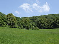
Cheddar Wood and the smaller Macall's Wood near Cheddar Gorge, are what remains of the wood of the Bishops of Bath and Wells in the thirteenth century and of King Edmund the Magnificent's wood in the tenth. It lies on carboniferous limestone with rock showing through the thin topsoils. In 1801 the wood was larger than it is today. During the nineteenth century its lower fringes were grubbed out to make strawberry fields, most of which have reverted to woodland. It was coppiced until 1917.[1]
This site compromises a range of habitats which includes ancient and secondary semi-natural broadleaved woodland, unimproved neutral grassland and a mosaic of calcareous grassland and acidic dry dwarf-shrub heath. Two nationally rare plant species are present. Additional interest lies in the invertebrate fauna. Cheddar Wood is one of only a few English stations for Starved Wood-sedge (Carex depauperata), which grows in the lane along the east side of the wood. [2] The nationally rare Purple Gromwell (Lithospermum purpurocaeruleum) grows in the lane along the west side of the wood.[2] Butterflies include Silver-washed Fritillary (Argynnis paphia), Dark Green Fritillary (Argynnis aglaja), Pearl-bordered Fritillary (Boloria euphrosyne), Holby Blue (Celastrina argiolus) and Brown Argus (Aricia agestis). The slug Arion fasciatus, which has a restricted distribution in the south of England, and the soldier beetle Cantharis fusca also occur.[3]
The site is managed as two nature reserves by Somerset Wildlife Trust Cheddar Wood Edge which covers 7.1 hectares (18 acres) of old strawberry fields, is now reverting to semi species-rich limestone grassland and scrub with ancient woodland hedges, and Cheddar Wood itself which has restricted access allowed by permit.
References
- ^ Aston, Michael (1988). Aspects of the medieval landscape of Somerset. Somerset County Council. p. 30. ISBN 0861831292.
- ^ a b Twist, Colin, Rare Plants in Great Britain - a site guide
- ^ "Cheddar Wood". English Nature. http://www.english-nature.org.uk/citation/citation_photo/1003970.pdf. Retrieved 2006-07-17.
Summarised data for all sites (biological and geological) Aller and Beer Woods · Aller Hill · Asham Wood · Axbridge Hill and Fry's Hill · Babcary Meadows · Barle Valley · Barrington Hill Meadows · Berrow Dunes · Black Down and Sampford Commons · Brean Down · Bridgwater Bay · Briggins Moor · Catcott, Edington and Chilton Moors · Chancellor's Farm · Cheddar Complex · Cheddar Reservoir · Cheddar Wood · Cleeve Hill · Cogley Wood · Crook Peak to Shute Shelve Hill · Curry and Hay Moors · Deadman · Draycott Sleights · Dunster Park and Heathlands · East Polden Grasslands · Ebbor Gorge · Edford Woods and Meadows · Exmoor Coastal Heaths · Fivehead Woods and Meadow · Freshmoor · Friar's Oven · Ge-mare Farm Fields · Great Breach and Copley Woods · Grove Farm · Hardington Moor · Hestercombe House · Holme Moor & Clean Moor · King's Sedgemoor · Kingdown and Middledown · Kingweston Meadows · Lang's Farm · Langford Heathfield · Langmead and Weston Level · Long Lye · Long Lye Meadow · Longleat Woods · Millwater · Moorlinch · Nettlecombe Park · North Brewham Meadows · North Curry Meadow · North Exmoor · North Moor · Old Ironstone Works, Mells · Perch · Porlock Ridge and Saltmarsh · Postlebury Wood · Priddy Pools · Prior's Park & Adcombe Wood · Quantock Hills · Quants · Ringdown · River Barle · Rodney Stoke · Roebuck Meadows · Ruttersleigh · Severn Estuary · Shapwick Heath · Sharpham Moor Plot · South Exmoor · Southey and Gotleigh Moors · Southlake Moor · Sparkford Wood · St. Dunstan's Well Catchment · Stowell Meadow · Street Heath · Tealham and Tadham Moors · Thurlbear Wood and Quarrylands · Twinhills Woods and Meadows · Vallis Vale · Walton and Ivythorn Hills · West Moor · West Sedgemoor · Westhay Heath · Westhay Moor · Wet Moor · Whitevine Meadows · Windsor Hill Marsh · Wookey Hole · Woolhayes FarmNeighbouring areas: Avon · Devon · Dorset · Wiltshire Categories:- Mendip Hills
- Sites of Special Scientific Interest in Somerset
- Sites of Special Scientific Interest notified in 1967
- Nature reserves in Somerset
- Woodland Sites of Special Scientific Interest
- Forests and woodlands of England
Wikimedia Foundation. 2010.

