- Dolebury Warren
-
Dolebury Warren Site of Special Scientific Interest 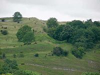
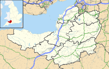
 Shown within Somerset
Area of Search Avon Grid reference ST455590 Coordinates 51°19′39″N 2°47′01″W / 51.32747°N 2.78358°WCoordinates: 51°19′39″N 2°47′01″W / 51.32747°N 2.78358°W Interest Biological Area 90.6 hectares (0.906 km2; 0.350 sq mi) Notification 1952 Natural England website Dolebury Warren (grid reference ST455590) is a 90.6 hectare biological Site of Special Scientific Interest (SSSI) near the village of Churchill in North Somerset, notified in 1952. It is owned by the National Trust and managed by the Avon Wildlife Trust.
There is evidence of occupation of the site during the Iron Age and as a medieval/post medieval rabbit warren.
Contents
Background
Further information: Hill fortHill forts developed in the Late Bronze and Early Iron Age, roughly the start of the first millennium BC.[1] The reason for their emergence in Britain, and their purpose, has been a subject of debate. It has been argued that they could have been military sites constructed in response to invasion from continental Europe, sites built by invaders, or a military reaction to social tensions caused by an increasing population and consequent pressure on agriculture. The dominant view since the 1960s has been that the increasing use of iron led to social changes in Britain. Deposits of iron ore were located in different places to the tin and copper ore necessary to make bronze, and as a result trading patterns shifted and the old elites lost their economic and social status. Power passed into the hands of a new group of people.[2] Archaeologist Barry Cunliffe believes that population increase still played a role and has stated "[the forts] provided defensive possibilities for the community at those times when the stress [of an increasing population] burst out into open warfare. But I wouldn't see them as having been built because there was a state of war. They would be functional as defensive strongholds when there were tensions and undoubtedly some of them were attacked and destroyed, but this was not the only, or even the most significant, factor in their construction".[3]
Construction
 Earthworks at Dolebury Camp
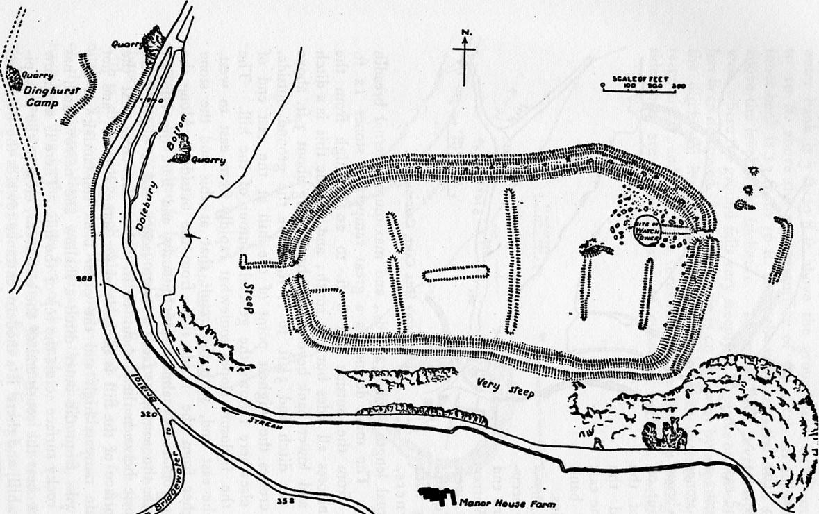
There is evidence of occupation of the site during the Iron Age,[4] which has been designated as a Scheduled Ancient Monument (No: 194279).[5]
The defences and Celtic field systems at Dolebury date back to the 4th century-3rd century BCE, though they might mask earlier developments.[6] The rectangular fort commands views over the surrounding countryside. It was protected by a limestone rampart with a ditch and counterscarp on all sides but the South. There is an inturned entrance on the West and an annexe of 0.4ha protecting the easier Eastern approach. Finds include Iron-age and Romano-British materials.[7]
In addition to the remains of double ramparts of an Iron Age hill fort still being visible there is also evidence of a medieval rabbit warren.[8]
Medieval
Dolebury Warren is a very good example of a medieval/post medieval rabbit warren which was used to breed rabbits, providing valuable meat and fur. The warren is completely enclosed by the substantial ramparts of the Iron Age hillfort, Dolebury Camp. Many warrens were surrounded by banks or walls to prevent the rabbits from escaping; escaped rabbits caused damage to nearby farmland and meant a loss in profit.[9] Reusing the hillforts defences as a boundary provided an ideal location in which to breed rabbits.
Ecology
Scarce plants found at the warren include Knotted Pearlwort[10] and Slender Bedstraw.[11]
See also
- List of hill forts and ancient settlements in Somerset
References
- ^ Payne, Andrew; Corney, Mark; Cunliffe, Barry (2007), The Wessex Hillforts Project: Extensive Survey of Hillfort Interiors in Central Southern England, English Heritage, p. 1, ISBN 9781873592854, http://www.english-heritage.org.uk/server/show/ConWebDoc.10744
- ^ Sharples, Niall M (1991), English Heritage Book of Maiden Castle, London: B. T. Batsford, pp. 71–72, ISBN 0-7134-6083-0
- ^ Time Team: Swords, skulls and strongholds, Channel 4, 2008-05-19, http://www.channel4.com/history/microsites/T/timeteam/2008/swords/swords-found.html, retrieved 16 September 2009
- ^ "Mendip Hills An Archaeological Survey of the Area of Outstanding Natural Beauty". Somerset County Council Archeological Projects. http://www1.somerset.gov.uk/archives/hes/downloads/HES_MendipAONB.pdf. Retrieved 16 January 2011.
- ^ "Dolebury Camp". National Monuments Record. English Heritage. http://www.pastscape.org.uk/hob.aspx?hob_id=194279. Retrieved 16 March 2011.
- ^ "Tower Head and Dolebury Warren". Isle of Avalon. http://www.isleofavalon.co.uk/sacredsites/towerhead.html. Retrieved 2006-10-28.
- ^ "Dolebury". Roman Britain. http://www.roman-britain.org/celtic/dolebury.htm. Retrieved 2010-11-14.
- ^ "Dolebury Warren". Avon Wildlife Trust. Archived from the original on 2006-10-09. http://web.archive.org/web/20061009124558/http://www.avonwildlifetrust.org.uk/level1/reserves/dolebury.htm. Retrieved 2006-10-28.
- ^ Williamson, T., 2006. The Archaeology of Rabbit Warrens. Princes Risborough: Shire Archaeology
- ^ Myles (2000) page 81
- ^ Myles (2000), page 191
Bibliography
- Myles, Sarah (2000) The Flora of the Bristol Region ISBN 1-874357-18-8
Source
- English Nature citation sheet for the site (accessed on 16 July 2006)
External links
- Dolebury Warren on Avon Wildlife Trust website
- Dolebury Hill Fort photo from English Heritage
- Rowberrow Camp at Digital Digging
Mendip Hills Settlements: Ashwick · Axbridge · Banwell · Bishop Sutton · Blagdon · Bleadon · Burrington · Charterhouse · Cheddar · Chewton Mendip · Compton Bishop · Compton Martin · Cross · Draycott · East Harptree · Easton · Hinton Blewett · Hutton · Leigh-on-Mendip · Litton · Oakhill · Priddy · Rodney Stoke · Rowberrow · Sandford · Shepton Mallet · Shipham · Ubley · Webbington · Wells · West Harptree · Westbury-sub-Mendip · Winscombe · Wookey HoleRivers and lakes: River Axe · Cheddar Yeo · River Chew · River Yeo · Lox Yeo River · Blagdon Lake · Cheddar Reservoir · Chew Valley Lake · Litton ReservoirsHills Axbridge Hill · Black Down · Bleadon Hill · Burledge Hill · Crook Peak · Fry's Hill · Pen Hill · Purn Hill · Shute Shelve Hill · Wavering DownCaves and gorges: Attborough Swallet · Aveline's Hole · Axbridge Ochre Mine · Banwell Caves · Banwell Ochre Caves · Burrington Combe · Charterhouse Cave · Cheddar Gorge · Compton Martin Ochre Mine · Cox's Cave · Eastwater Cavern · Ebbor Gorge · Fairy Cave Quarry · GB Cave · Goatchurch Cavern · Gough's Cave · Hunter's Hole · Lamb Leer · Longwood Swallet · Pierre's Pot · Priddy Caves · Rod's Pot · Shatter Cave · Shute Shelve Cavern · Sidcot Swallet · St Cuthbert's Swallet · St. Dunstan's Well Catchment · Stoke Lane Slocker · Swildon's Hole · Thrupe Lane Swallet · Tyning's Barrow Swallet · Upper Flood Swallet · W/L Cave · Wookey Hole CavesQuarries: Batts Combe · Callow Rock · Cloford · Cloud · Colemans · Cook's Wood · Doulting Stone · Dulcote · Emborough · Fairy Cave · Gurney Slade · Halecombe · Hobbs · Holwell · Moon's Hill · Torr Works · Viaduct · Whatley · Windsor HillSSSIs: Asham Wood · Axbridge Hill and Fry's Hill · Banwell Caves · Banwell Ochre Caves · Barns Batch Spinney · Blagdon Lake · Bleadon Hill · Brimble Pit and Cross Swallet Basins · Burledge Hill · Burrington Combe · Chancellor's Farm · Cheddar Complex · Cheddar Reservoir · Cheddar Wood · Chew Valley Lake · Cloford Quarry · Compton Martin Ochre Mine · Cook's Wood Quarry · Crook Peak to Shute Shelve Hill · Dolebury Warren · Draycott Sleights · Ebbor Gorge · Emborough Quarries · Harptree Combe · Hobbs Quarry · Holwell Quarries · Kingdown and Middledown · Lamb Leer · Priddy Caves · Priddy Pools · Perch · Rodney Stoke · St. Dunstan's Well Catchment · Sandpit Hole and Bishop's Lot · Shiplate Slait · Viaduct Quarry · Windsor Hill Quarry · Wurt Pit and Devil's PunchbowlHistory Transport Councils: Surrounding areas: Categories:- Mendip Hills
- Hill forts in Somerset
- History of Somerset
- Sites of Special Scientific Interest in North Somerset
- Sites of Special Scientific Interest notified in 1952
- Nature reserves in Somerset
- National Trust properties in Somerset
- Former populated places in England
- Scheduled Ancient Monuments in Somerset


Wikimedia Foundation. 2010.