- Cheddar Complex
-
Cheddar Complex Site of Special Scientific Interest 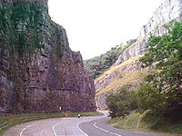
 Shown within Somerset
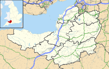
Area of Search Somerset Grid reference ST465538 Coordinates 51°16′51″N 2°46′06″W / 51.28082°N 2.76844°WCoordinates: 51°16′51″N 2°46′06″W / 51.28082°N 2.76844°W Interest Biological and Geological Area 441.3 hectares (4.413 km2; 1.704 sq mi) Notification 1952 Natural England website The Cheddar Complex is a 441.3 hectare (1090.5 acre) biological Site of Special Scientific Interest near Cheddar around the Cheddar Gorge and north east to Charterhouse in the Mendip Hills, Somerset, notified in 1952.
This is a very large area which includes 4 SSSIs formerly known as Cheddar Gorge SSSI, August Hole/Longwood Swallet SSSI, GB Cavern Charterhouse SSSI and Charterhouse on-Mendip SSSI. It is part owned by the National Trust and part managed by the Somerset Wildlife Trust.
Contents
Biological
The Cheddar Complex supports a wide range of semi-natural habitats which includes unimproved grassland, calcareous dry dwarf-shrub heath, semi-natural broadleaved woodland and dense and scattered scrub. Four nationally rare plants are present, including Little Robin Geranium purpureum, Cheddar Pink Dianthus gratianopolitanus and Cheddar Bedstraw Galium fleurotii, two of which are endemic to the Cheddar area, as well as fifteen nationally scarce species.[1]
Geological
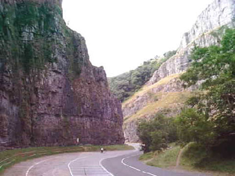
This site is important for karst, caves and vertebrate palaeontology and comprises four single interest localities. Cheddar Gorge is Britain’s largest gorge and probably the country’s best known limestone feature. It is a spectacular fluvial feature with a geomorphic history extending back 2 million years and encompassing the major environmental changes of the Pleistocene period. Cheddar Caves contain both active and fossil systems. The active cave system is one of the most heavily studied karst systems in Britain with reference to the conduit and diffuse flow characteristics of its hydrology. Charterhouse Caves include four major swallet caves that provide an indisputable record of Pleistocene landform development in the Mendips and surrounding area. Sun Hole Cave provides a varied fauna radiocarbon-dated to the end of the Late Devensian Cold Stage.[1]
Several types of limestone including Clifton Down Limestone, Cheddar Limestone and Cheddar Oolite are visible in the Gorge and surrounding areas with pale grey Burrington Oolite outcroping around Black Rock Gate.[2]
The Charterhouse area is of great importance as the finest remaining example of the unique Lead orefields of the Mendips. The surface features derived from lead working from pre-Roman times up to the nineteenth century are extremely well preserved.[1]
Somerset Wildlife Trust Reserves
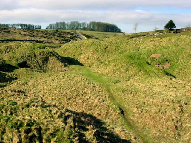
 The site of old mining works in Velvet Bottom
The area includes several nature reserves run by the Somerset Wildlife Trust. These include: Black Rock, Bubworth Acres, GB Gruffy, Long Wood, Mascall's Wood, Middledown, Ubley Warren and Velvet Bottom.[3]
The Black Rock reserve covers 181 acres (73 ha) of woodland, limestone grassland, conifers and an abandoned quarry. Long Wood covers 47 acres (19 ha) of ancient woodland and includes Longwood Swallet. It was historically the property of the Carthusian monks of Witham Charterhouse. In Roman times Velvet Bottom was mined for lead and the remains of circular buddle pits which were used to wash lead ore and settling beds can still be seen. Heaps of black shiny slag are the remains from re-smelting of the lead. It now consists of rough grassland, with areas of woodland and shrubs.[4] GB Gruffy includes 17 acres (6.9 ha) of neutral to acid species-rich grassland which overlies the GB Cave system.[5] The 86 acres (35 ha) of Ubley Warren are another site deeply affected by the lead mining in the area which lasted until the 19th century.[3]
See also
References
- ^ a b c "The Cheddar Complex". English Nature. http://www.english-nature.org.uk/citation/citation_photo/1003940.pdf. Retrieved 2 May 2011.
- ^ "Cheddar Gorge". British Geological Survey. http://www.bgs.ac.uk/mendips/localities/cheddar.html. Retrieved 2 May 2011.
- ^ a b "Nature Reserves Guide". Somerset Wildlife Trust. http://www.somersetwildlife.org/c2/uploads/reserves_guide_reprint_sml.pdf. Retrieved 2 May 2011.
- ^ "Cheddar Complex". Somerset Wildlife Trust. http://www.somersetwildlife.org/cheddar_complex.html. Retrieved 2 May 2011.
- ^ "GB Gruffy". Somerset Wildlife Trust. http://www.somersetwildlife.org/gb-gruffy.html. Retrieved 2 May 2011.
Summary SSSIs Ben Knowle · Blue Anchor to Lilstock Coast · Brean Down · Brimble Pit and Cross Swallet Basins · Bruton Railway Cutting · Cheddar Complex · Cloford Quarry · Cook's Wood Quarry · Crook Peak to Shute Shelve Hill · Doulting Railway Cutting · Emborough Quarries · Glenthorne · Godminster Lane Quarry and Railway Cutting · Greylake · Ham Hill · Hobbs Quarry · Holwell Quarries · Hurcott Farm · Hurcott Lane Cutting · Lamb Leer · Langport Railway Cutting · Laycock Railway Cutting · Leighton Road Cutting · Low Ham · Maes Down · Maesbury Railway Cutting · Miller's Hill, Milborne Wick · Moon's Hill Quarry · Priddy Caves · Priddy Pools · Rodney Stoke SSSI · Sandpit Hole and Bishop's Lot · Seavington St Mary · Shepton Montague Railway Cutting · Snowdon Hill Quarry · St. Dunstan's Well Catchment · Thrupe Lane Swallet · Vallis Vale · Viaduct Quarry · Windsor Hill Quarry · Wookey Hole · Wookey Station · Wurt Pit and Devil's Punchbowl
Neighbouring areas Avon · Devon · Dorset · Wiltshire
Summarised data for all sites (biological and geological) Aller and Beer Woods · Aller Hill · Asham Wood · Axbridge Hill and Fry's Hill · Babcary Meadows · Barle Valley · Barrington Hill Meadows · Berrow Dunes · Black Down and Sampford Commons · Brean Down · Bridgwater Bay · Briggins Moor · Catcott, Edington and Chilton Moors · Chancellor's Farm · Cheddar Complex · Cheddar Reservoir · Cheddar Wood · Cleeve Hill · Cogley Wood · Crook Peak to Shute Shelve Hill · Curry and Hay Moors · Deadman · Draycott Sleights · Dunster Park and Heathlands · East Polden Grasslands · Ebbor Gorge · Edford Woods and Meadows · Exmoor Coastal Heaths · Fivehead Woods and Meadow · Freshmoor · Friar's Oven · Ge-mare Farm Fields · Great Breach and Copley Woods · Grove Farm · Hardington Moor · Hestercombe House · Holme Moor & Clean Moor · King's Sedgemoor · Kingdown and Middledown · Kingweston Meadows · Lang's Farm · Langford Heathfield · Langmead and Weston Level · Long Lye · Long Lye Meadow · Longleat Woods · Millwater · Moorlinch · Nettlecombe Park · North Brewham Meadows · North Curry Meadow · North Exmoor · North Moor · Old Ironstone Works, Mells · Perch · Porlock Ridge and Saltmarsh · Postlebury Wood · Priddy Pools · Prior's Park & Adcombe Wood · Quantock Hills · Quants · Ringdown · River Barle · Rodney Stoke · Roebuck Meadows · Ruttersleigh · Severn Estuary · Shapwick Heath · Sharpham Moor Plot · South Exmoor · Southey and Gotleigh Moors · Southlake Moor · Sparkford Wood · St. Dunstan's Well Catchment · Stowell Meadow · Street Heath · Tealham and Tadham Moors · Thurlbear Wood and Quarrylands · Twinhills Woods and Meadows · Vallis Vale · Walton and Ivythorn Hills · West Moor · West Sedgemoor · Westhay Heath · Westhay Moor · Wet Moor · Whitevine Meadows · Windsor Hill Marsh · Wookey Hole · Woolhayes FarmNeighbouring areas: Avon · Devon · Dorset · Wiltshire Categories:- Mendip Hills
- Sites of Special Scientific Interest in Somerset
- Sites of Special Scientific Interest notified in 1952

Wikimedia Foundation. 2010.