- Compton Martin Ochre Mine
-
Compton Martin Ochre Mine Site of Special Scientific Interest 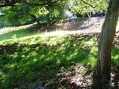
The site of Compton Martin Ochre Mine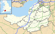
 Shown within Somerset
Area of Search Avon Grid reference ST543566 Coordinates 51°18′24″N 2°39′25″W / 51.3067°N 2.6570°WCoordinates: 51°18′24″N 2°39′25″W / 51.3067°N 2.6570°W Interest Geological and Biological Area 2.1 acres (0.0085 km2; 0.0033 sq mi) Notification 1988 Natural England website Compton Martin Ochre Mine (grid reference ST543566) is a 0.85 hectare geological and biological Site of Special Scientific Interest located on the north side of the Mendip Hills, immediately south west of Compton Martin village, Somerset, notified in 1988.
Contents
Geological Interest
It is a Geological Conservation Review site. The site comprises a network of underground tunnels and surface exposures on the eastern fringe of Compton Wood. The site exposes bedded hematitic iron ore (red ochre) in Triassic Dolomitic Conglomerates which was deposited underwater as a layered mass of iron oxide pellets of various types, probably in an ephemeral lake or pond fed by hot springs when the Mendip area was occupied by a desert environment some 220 million years ago during late Triassic times.[1]
Red ochre is an iron oxide mineral, which was used in paint-making. It is believed that the mine was owned by Mendi Oxide & Ochre Co. Ltd., of Wick.
Biological Interest
The mines are also used as a hibernation site by Greater Horseshoe Bats (Rhinolophus ferrumequinum). A rare and endangered species, the greater horseshoe bat is protected under the Wildlife and Countryside Act 1981 and is listed in Annex II of the 1992 European Community Habitats Directive.[1]
Along with Combe Down and Bathampton Down Mines this site forms a key part of the ‘Bath and Bradford-on-Avon Bats’ candidate Special Area of Conservation (cSAC).[2]
References
- ^ a b "Compton Martin Ochre Mine". English Nature. http://www.english-nature.org.uk/citation/citation_photo/1004205.pdf. Retrieved 2006-05-09.
- ^ "Chapter 2: The natural environment". Local Plan. Bath and North East Somerset. http://www.bathnes.gov.uk/localplans/banes2003v2/ListofRevisionsHTM/ChapterC2NaturalDevelopment.htm. Retrieved 2008-10-21.
See also
External links
- Compton Martin Ochre Mine (Mineralogy of the Mendips) GCR database
- Compton Martin Ochre Mine
- Compton Martin Village website
- English Nature (SSSI information)
Chew Valley Villages: Belluton · Bishop Sutton · Blagdon · Burnett · Cameley · Camerton · Chelwood · Chew Magna · Chew Stoke · Chewton Keynsham · Chewton Mendip · Clutton · Compton Dando · Compton Martin · East Harptree · High Littleton · Hinton Blewett · Hunstrete · Keynsham · Litton · Marksbury · Nempnett Thrubwell · Norton Malreward · Pensford · Publow · Regil · Stanton Drew · Stanton Prior · Stowey · Temple Cloud · Timsbury · Ubley · West Harptree · Winford · WoollardReservoirs: Rivers: SSSIs: Barns Batch Spinney · Blagdon Lake · Burledge Hill · Chew Valley Lake · Compton Martin Ochre Mine · Dundry Main Road South Quarry · Emborough Quarries · Folly Farm · Harptree Combe · Hartcliff Rocks Quarry · Lamb Leer · Lulsgate Quarry · Plaster's Green Meadows · Wurt Pit and Devil's PunchbowlOpen Access Land Councils: Surrounding areas: Ashton Court · Avon Gorge · Banwell Caves · Biddle Street, Yatton · Bishop's Hill Wood · Blagdon Lake · Bodkin Hazel Wood · Brockley Hall Stables · Brown's Folly · Burledge Sidelands and Meadows · Burrington Combe · Chew Valley Lake · Cleaves Wood · Cleeve Wood, Hanham · Combe Down and Bathampton Down Mines · Compton Martin Ochre Mine · Congrove Field and The Tumps · Dolebury Warren · Ellenborough Park West · Folly Farm · Goblin Combe · Gordano Valley · Harptree Combe · Hawkesbury Meadow · Hinton Charterhouse Field · Horseshoe Bend, Shirehampton · Iford Manor · King's Wood and Urchin Wood · Long Dole Wood and Meadows · Lower Woods · Max Bog · Middle Hope · Midger · Monkswood Valley · Plaster's Green Meadows · Purn Hill · Puxton Moor · Severn Estuary · Shiplate Slait · St. Catherine's Valley · Steep Holm · Tickenham, Nailsea and Kenn Moors · Uphill Cliff · Upton Coombe · Walton Common · Weston Big Wood · Yanal BogNeighbouring areas: Gloucestershire · Somerset · Wiltshire Aust Cliff · Avon Gorge · Banwell Caves · Banwell Ochre Caves · Barnhill Quarry · Barns Batch Spinney · Bickley Wood · Bleadon Hill · Bourne · Bowlditch Quarry · Brinkmarsh Quarry · Brown's Folly · Buckover Road Cutting · Burrington Combe · Cattybrook Brickpit · Clevedon Shore · Compton Martin Ochre Mine · Court Hill · Cullimore's Quarry · Damery Road Section · Dundry Main Road South Quarry · Gordano Valley · Ham Green · Hampton Rocks Cutting · Hartcliff Rocks Quarry · Hawkesbury Quarry · Hinton Charterhouse Pit · Hinton Hill, Wellow · Holly Lane · Huish Colliery Quarry · Kenn Church, Kenn Pier & Yew Tree Farm · Kilmersdon Road Quarry · Lower Woods · Lulsgate Quarry · Middle Hope · Newton St Loe · Nightingale Valley · North Road Quarry, Bath · Portishead Pier to Black Nore · Quarry Steps, Durdham Down · Severn Estuary · Slickstones Quarry, Cromhall · Spring Cove Cliffs · Stidham Farm · Tytherington Quarry · Weston-in-Gordano · Winterbourne Railway Cutting · Writhlington
Neighbouring areas: Gloucestershire · Somerset · Wiltshire
Categories:- Mendip Hills
- Bath and North East Somerset
- Environment of Somerset
- Sites of Special Scientific Interest in Avon
- Sites of Special Scientific Interest notified in 1988
- Bat roosts in England
- Limestone caves


Wikimedia Foundation. 2010.