- Compton Dando
-
Coordinates: 51°22′49″N 2°30′23″W / 51.3802°N 2.5065°W
Compton Dando 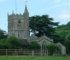
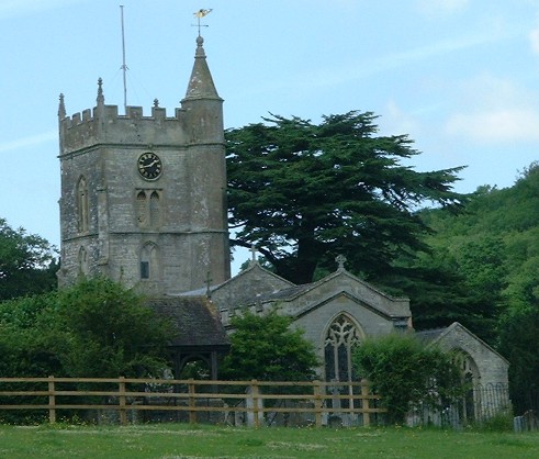
St Mary's Church, Compton Dando
 Compton Dando
Compton Dando shown within SomersetPopulation 613 (2001) OS grid reference ST647647 Parish Compton Dando Unitary authority Bath and North East Somerset Ceremonial county Somerset Region South West Country England Sovereign state United Kingdom Post town BRISTOL Postcode district BS40 Dialling code 01761 Police Avon and Somerset Fire Avon Ambulance Great Western EU Parliament South West England UK Parliament North East Somerset List of places: UK • England • Somerset Compton Dando is a small village and civil parish on the River Chew in the Chew Valley in England. It is in the District of Bath and North East Somerset and ceremonial county of Somerset, and lies 7 miles (11.3 km) from Bristol, 8 miles (12.9 km) from Bath, and 3 miles (4.8 km) from Keynsham. The parish has a population of 613.[1]
The parish includes the villages of Burnett and Queen Charlton, where there is a 12th century Church of St Margaret. It has been designated by English Heritage as a Grade II* listed building.[2] There is a late medieval cross on the village green.[3]
Contents
History
It is on the route of the ancient Wansdyke,[4] and lies on the Monarch's Way long-distance footpath.
According to Robinson it is listed in the 1086 Domesday Book as Comtuna. A compton was originally a 'valley enclosure'. In 1297 the name Dando was added after Godfrey or Geofrey de Anno.[5]
The parish of Compton Dando was part of the Keynsham Hundred,[6]
The village was held by Alexander de Alno in the 12th century.
Governance
The parish council has responsibility for local issues, including setting an annual precept (local rate) to cover the council’s operating costs and producing annual accounts for public scrutiny. The parish council evaluates local planning applications and works with the local police, district council officers, and neighbourhood watch groups on matters of crime, security, and traffic. The parish council's role also includes initiating projects for the maintenance and repair of parish facilities, such as the village hall or community centre, playing fields and playgrounds, as well as consulting with the district council on the maintenance, repair, and improvement of highways, drainage, footpaths, public transport, and street cleaning. Conservation matters (including trees and listed buildings) and environmental issues are also of interest to the council.
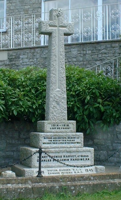
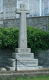 War Memorial in Compton Dando
Compton Dando is part of the Farmborough Ward which is represented by one councillor on the unitary authority of Bath and North East Somerset which was created in 1996, as established by the Local Government Act 1992. It provides a single tier of local government with responsibility for almost all local government functions within its area including local planning and building control, local roads, council housing, environmental health, markets and fairs, refuse collection, recycling, cemeteries, crematoria, leisure services, parks, and tourism. They are also responsible for education, social services, libraries, main roads, public transport, trading standards, waste disposal and strategic planning, although fire, police and ambulance services are provided jointly with other authorities through the Avon Fire and Rescue Service, Avon and Somerset Constabulary and the Great Western Ambulance Service.
Bath and North East Somerset's area covers part of the ceremonial county of Somerset but it is administered independently of the non-metropolitan county. Its administrative headquarters is in Bath. Between 1 April 1974 and 1 April 1996, it was the Wansdyke district and the City of Bath of the county of Avon.[7] Before 1974 that parts of the parish was part of the Bathavon Rural District[8] and Keynsham Urban District.[9]
The parish is represented in the House of Commons of the Parliament of the United Kingdom as part of North East Somerset. It elects one Member of Parliament (MP) by the first past the post system of election. It is also part of the South West England constituency of the European Parliament which elects seven MEPs using the d'Hondt method of party-list proportional representation.
Demographics
According to the 2001 Census the Farmborough Ward (which includes Woollard and Chewton Keynsham), had 1,111 residents, living in 428 households, with an average age of 44.5 years. Of these 71% of residents describing their health as 'good', 21% of 16-74 year olds had no qualifications; and the area had an unemployment rate of 1.0% of all economically active people aged 16-74. In the Index of Multiple Deprivation 2004, it was ranked at 22,100 out of 32,482 wards in England, where 1 was the most deprived LSOA and 32,482 the least deprived.[10]
Church
The church, dedicated to St Mary, is a small edifice in the Gothic style, with a square tower. It has a date of 1735 on the chancel, but is mostly Victorian,[11] although Wade and Wade in their 1929 book Somerset suggest "The church is of 14th-cent. workmanship, but the chancel and S. porch respectively bear the dates 1793 and 1735 (probably referring to repairs). Within is a piscina and Norm. font. The churchyard contains a good sundial."[12] It is a Grade II listed building.[13]
Manor House
The 16th-century Manor House is a Grade II* listed building.[14]
Other Grade II listed buildings
 Compton Arms, Compton Dando
- Bridge and attached wall and fence across the River Chew at Images of England
- Archway to north of Manor Farmhouse and opposite Manor at Images of England
- Burnett House at Images of England
- Burnett Church of St Michael at Images of England
- Church View at Images of England
- Compton Cottage at Images of England
- Court Hill House at Images of England
- Cross Cottage and Manor Farm Cottage at Images of England
- K6 Telephone kiosk at Images of England
- Burnett Manor Farmhouse at Images of England
- Mill Farmhouse at Images of England
- Burnett Monument to A'Court Family at Images of England
- Burnett Monument to Ford Family at Images of England
- Priory Farmhouse at Images of England
- Road Bridge over the River Chew at Images of England
- The Gamekeeper Public House at Images of England
- The Rectory at Images of England
- Tucking Mill Farmhouse at Images of England
- Unidentified Monument at Images of England
- Village School and adjoining School House at Images of England
- Wansdyke Cottage at Images of England
- Wick Farmhouse at Images of England
Notable residents
The author Dick King-Smith lived in Queen Charlton until his death in 2011.[15]
References
- ^ "Population Statistics for Bath & North East Somerset". Statistics and Census Information. Bath and North East Somerset. http://www.bathnes.gov.uk/councilanddemocracy/statisticsandcensusinformation/Pages/default.aspx. Retrieved 2010-10-05.
- ^ "Church of St Margaret". Images of England. http://www.imagesofengland.org.uk/details/default.aspx?id=32468. Retrieved 2008-01-13.
- ^ "Cross on Village Green, in front of Tolzey Cottage". Images of England. http://www.imagesofengland.org.uk/details/default.aspx?id=32481. Retrieved 2008-01-13.
- ^ Roe, Margaret; Rebecca Palmer (2001). The Village of Compton Dando. The authors.
- ^ Robinson, Stephen (1992). Somerset Place Names. Wimborne, Dorset: The Dovecote Press Ltd. ISBN 1874336032.
- ^ "Somerset Hundreds". GENUKI. http://www.genuki.org.uk/big/eng/SOM/Miscellaneous/. Retrieved 15 October 2011.
- ^ "The Avon (Structural Change) Order 1995". HMSO. http://www.opsi.gov.uk/si/si1995/Uksi_19950493_en_1.htm. Retrieved 2007-12-09.
- ^ A Vision of Britain Through Time : Bathavon Rural District
- ^ A Vision of Britain Through Time : Keynsham Urban District
- ^ "Neighbourhood Statistics LSOA Bath and North East Somerset 016B Farmborouch". Office of National Statistics 2001 Census. http://neighbourhood.statistics.gov.uk/dissemination/LeadProfileSearch.do?profileSearchText=BS39+4LW&searchProfiles=. Retrieved 2006-05-01.
- ^ Pevsner, Nikolaus (1958). The Buildings of England: North Somerset and Bristol. Penguin Books. ISBN 0-14-071013-2.
- ^
- ^ Church of St Mary at Images of England
- ^ Manor House at Images of England
- ^ "Author Dick King-Smith dies, aged 88". Evening Post. This is Bristol. http://www.thisisbristol.co.uk/news/Author-Dick-King-Smith-dies-aged-88/article-3069806-detail/article.html. Retrieved 5 January 2011.
External links
Chew Valley Villages: Belluton · Bishop Sutton · Blagdon · Burnett · Cameley · Camerton · Chelwood · Chew Magna · Chew Stoke · Chewton Keynsham · Chewton Mendip · Clutton · Compton Dando · Compton Martin · East Harptree · High Littleton · Hinton Blewett · Hunstrete · Keynsham · Litton · Marksbury · Nempnett Thrubwell · Norton Malreward · Pensford · Publow · Regil · Stanton Drew · Stanton Prior · Stowey · Temple Cloud · Timsbury · Ubley · West Harptree · Winford · WoollardReservoirs: Rivers: SSSIs: Open Access Land Councils: Surrounding areas: Categories:- Monarch's Way
- Civil parishes in Somerset
- Villages in Bath and North East Somerset


Wikimedia Foundation. 2010.