- Church of St Margaret, Queen Charlton
-
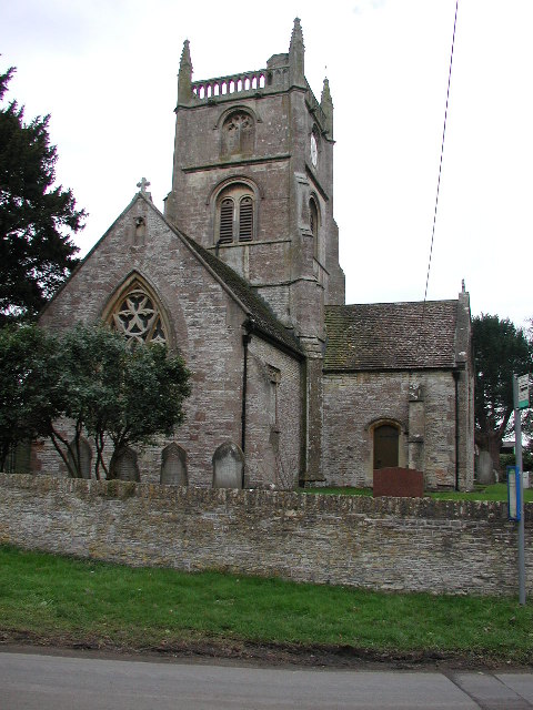
Church of St Margaret 
Location: Queen Charlton, Somerset, England Coordinates: 51°24′03″N 2°31′38″W / 51.40083°N 2.52722°WCoordinates: 51°24′03″N 2°31′38″W / 51.40083°N 2.52722°W Built: late 12th century Listed Building – Grade II* Designated: 1 February 1956 Reference #: 32468[1] 
 Location of Church of St Margaret in Somerset
The Anglican Church of St Margaret in Queen Charlton, Somerset, England dates from the late 12th century. It has been designated by English Heritage as a Grade II* listed building.[1] It is within the civil parish of Compton Dando, but the ecclesiastical parish of Keynsham and the Diocese of Bath & Wells.[2]
The church was attached to Keynsham Abbey but also had its own collection of ecclesiastical buildings around 1200.[3]
The building was altered in the 13th century and restored in the 15th.[1] It was originally cruciform, but only the north transept remains.[3]
The central tow-stage tower is supported by diagonal buttresses are topped with a parapet with pierced arcading surrounded by pinnacles and gargoyles. It has a polygonal stair tower on the north east corner.[1] Beneath the tower at the crossing at four arches with attached Norman pillars.[3]
In front of the church is a late medieval cross on the village green.[4] It was previously sited further east of its current location but was moved as part of the celebrations for the Jubilee of Queen Victoria.[3]
References
- ^ a b c d "Church of St Margaret". Images of England. English Heritage. http://www.imagesofengland.org.uk/details/default.aspx?id=32468. Retrieved 18 December 2010.
- ^ "St Margaret, Queen Charlton". A church near you. http://www.achurchnearyou.com/queen-charlton-st-margaret/. Retrieved 18 December 2010.
- ^ a b c d Robinson, W.J. (1915). West Country Churches. Bristol: Bristol Times and Mirror Ltd. pp. 135–138.
- ^ "Cross on Village Green, in front of Tolzey Cottage". Images of England. English Heritage. http://www.imagesofengland.org.uk/details/default.aspx?id=32481. Retrieved 18 December 2010.
Categories:- 12th-century architecture
- Grade II* listed churches
- Grade II* listed buildings in Somerset
- Church of England churches in Bath and North East Somerset

Wikimedia Foundation. 2010.