- Cranmore, Somerset
-
Coordinates: 51°11′23″N 2°28′43″W / 51.1896°N 2.4787°W
Cranmore 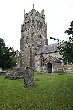
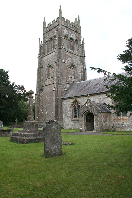
Church of St Bartholomew, Cranmore
 Cranmore
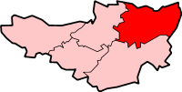
Cranmore shown within SomersetPopulation 520 [1] OS grid reference ST665435 District Mendip Shire county Somerset Region South West Country England Sovereign state United Kingdom Post town SHEPTON MALLET Postcode district BA4 Dialling code 01749 Police Avon and Somerset Fire Devon and Somerset Ambulance South Western EU Parliament South West England UK Parliament Wells List of places: UK • England • Somerset Cranmore is a village and civil parish east of Shepton Mallet, in the Mendip district of Somerset, England. The parish includes the hamlets of Waterlip, East Cranmore and Dean where Dean farmhouse dates from the 17th century,[2] as does The Old Smithy, just off the A361 which was originally two residential dwellings before being finally "knocked through" to just one.[3]
Contents
History
The name comes from Crane Mere, the Lake of the Cranes.[4]
The parish of Cranmore was part of the hundred of Wells Forum.[5] East Cranmore was part of the hundred of Frome.[6]
It is the base of the East Somerset Railway which plays host to a variety of preserved diesel and steam locomotives. It operates the line between Cranmore railway station, Cranmore West, Merryfield Lane Halt and Mendip Vale. The section between Cranmore and the mainline is used for heavy quarry traffic to the nearby Merehead Quarry. The quarry, which is also known as Torr Works, covers an area of some 200 hectares, including 60 hectares which have been landscaped to blend with the surrounding countryside. It is operated by the Foster Yeoman Company employing over 200 people and produces 6 million tonnes of limestone annually which is carried directly from the quarry by Mendip Rail.
Cranmore Hall is a large 17th-century country house with landscaped gardens which now forms the main portion of All Hallows Preparatory School.[7] Southill House is a smaller country house dating from the early 18th century which was refacaded by John Wood, the Younger.[8]
On a hill north of the village is the 45 metres (148 ft) tall Victorian folly, Cranmore Tower, built in 1862–64 by Thomas Henry Wyatt for John Moore Paget. The site is 280 metres (919 ft) above sea level, and is the highest point on the Mendip Way.
Governance
The parish council has responsibility for local issues, including setting an annual precept (local rate) to cover the council’s operating costs and producing annual accounts for public scrutiny. The parish council evaluates local planning applications and works with the local police, district council officers, and neighbourhood watch groups on matters of crime, security, and traffic. The parish council's role also includes initiating projects for the maintenance and repair of parish facilities, as well as consulting with the district council on the maintenance, repair, and improvement of highways, drainage, footpaths, public transport, and street cleaning. Conservation matters (including trees and listed buildings) and environmental issues are also the responsibility of the council.
The village falls within the Non-metropolitan district of Mendip, which was formed on 1 April 1974 under the Local Government Act 1972, having previously been part of Shepton Mallet Rural District,[9] which is responsible for local planning and building control, local roads, council housing, environmental health, markets and fairs, refuse collection and recycling, cemeteries and crematoria, leisure services, parks, and tourism.
Somerset County Council is responsible for running the largest and most expensive local services such as education, social services, libraries, main roads, public transport, policing and fire services, trading standards, waste disposal and strategic planning.
It is also part of the Wells county constituency represented in the House of Commons of the Parliament of the United Kingdom. It elects one Member of Parliament (MP) by the first past the post system of election, and part of the South West England constituency of the European Parliament which elects seven MEPs using the d'Hondt method of party-list proportional representation.
Landmarks
Southill House is an early 18th century manor house south of the main village. It was given a new facade by John Wood, the Younger, of Bath, in the late 18th century.[10]
Religious sites
The Church of St Bartholomew dates from the 15th century and has been designated by English Heritage as a Grade I listed building.[11] The former church of St James in East Cranmore has been deconsecrated and is now used as a private dwelling.[12]
References
- ^ "Parish Population Statistics". ONS Census 2001. Somerset County Council. http://www.webcitation.org/5lRyC5ccr. Retrieved 14 December 2009.
- ^ "Dean Farmhouse". Images of England. http://www.imagesofengland.org.uk/details/default.aspx?id=268263. Retrieved 1 February 2008.
- ^ "The Old Smithy". Images of England. http://www.imagesofengland.org.uk/details/default.aspx?id=268265. Retrieved 1 February 2008.
- ^ "Cranmore". Cranmore village website. http://www.cranmore.org/. Retrieved 14 November 2010.
- ^ "Somerset Hundreds". GENUKI. http://www.genuki.org.uk/big/eng/SOM/Miscellaneous/. Retrieved 12 September 2011.
- ^ "Somerset Hundreds". GENUKI. http://www.genuki.org.uk/big/eng/SOM/Miscellaneous/. Retrieved 8 October 2011.
- ^ "Cranmore Hall, walling and gazebo, now part of All Hallows School". Images of England. http://www.imagesofengland.org.uk/Details/Default.aspx?id=268267. Retrieved 25 March 2008.
- ^ "Southill House and outbuildings". Images of England. http://www.imagesofengland.org.uk/Details/Default.aspx?id=268253. Retrieved 25 March 2008.
- ^ A Vision of Britain Through Time : Shepton Mallet Rural District
- ^ "Southill House and outbuildings". Images of England. English Heritage. http://www.imagesofengland.org.uk/details/default.aspx?id=268253. Retrieved 19 May 2009.
- ^ "Church of St Bartholomew". Images of England. http://www.imagesofengland.org.uk/Details/Default.aspx?id=268259. Retrieved 25 March 2008.
- ^ "Church of St James". Images of England. http://www.imagesofengland.org.uk/Details/Default.aspx?id=268271. Retrieved 25 March 2008.
External links
Towns, villages and hamlets in the Mendip district of Somerset, England  Ashwick · Baltonsborough · Batcombe · Beckington · Berkley · Binegar · Buckland Dinham · Chewton Mendip · Chilcompton · Coleford · Cranmore · Croscombe · Ditcheat · Doulting · Downhead · East Lydford · East Pennard · Emborough · Evercreech · Frome · Glastonbury · Godney · Great Elm · Hemington · Holcombe · Kilmersdon · Lamyat · Leigh-on-Mendip · Litton · Lullington · Lydford-on-Fosse · Meare · Mells · Milton Clevedon · North Wootton · Norton St Philip · Nunney · Pilton · Priddy · Pylle · Rode · Rodney Stoke · Rudge · Selwood · Sharpham · Shepton Mallet · St Cuthbert Out · Stoke St Michael · Ston Easton · Stratton-on-the-Fosse · Street · Tellisford · Trudoxhill · Upton Noble · Walton · Wanstrow · Wells · West Bradley · West Lydford · West Pennard · Westbury-sub-Mendip · Whatley · Witham Friary · Wookey · Wookey HoleCategories:
- Villages in Mendip
- Civil parishes in Somerset

Wikimedia Foundation. 2010.