- Ditcheat
-
Coordinates: 51°07′35″N 2°32′07″W / 51.1264°N 2.5352°W
Ditcheat 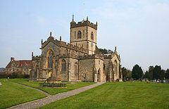
Church of St Mary Magdalene, Ditcheat
 Ditcheat
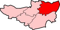
Ditcheat shown within SomersetPopulation 752 [1] OS grid reference ST625365 District Mendip Shire county Somerset Region South West Country England Sovereign state United Kingdom Post town SHEPTON MALLET Postcode district BA4 Dialling code 01749 Police Avon and Somerset Fire Devon and Somerset Ambulance South Western EU Parliament South West England UK Parliament Somerton and Frome List of places: UK • England • Somerset Ditcheat is a village and civil parish 4.5 miles (7 km) south of Shepton Mallet, and 2.5 miles (4 km) north-west of Castle Cary, in the Mendip district of Somerset, England. The parish of Ditcheat incorporates three hamlets: Wraxall, Alhampton and Sutton.
Contents
History
In the Domesday book of 1086, Ditcheat belonged to Glastonbury Abbey and contained 36 families.[2] The parish of Ditcheat was part of the Whitstone Hundred.[3]
Its primary infrastructure connections consist of the A37, 1.5 miles (2 km) west, connecting Bristol and Yeovil or the A371, 1 mile (2 km) east, connecting Shepton Mallet and Wincanton. It is situated near the River Brue which is crossed by Ansford bridge which dates from 1823.[4] Boulter's Bridge which spans the River Alham is of medieval origin[5] and has been designated as a Scheduled Ancient Monument.[6] The parish is close to the Roman Fosse Way.
 Ditcheat Manor House
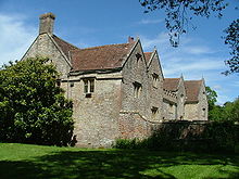
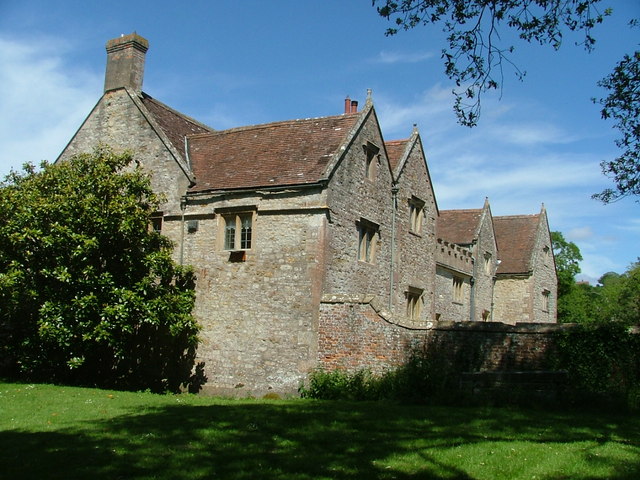
The Manor House, formerly known as Ditcheat House or Ditcheat Manor, is a 17th-century manor house built by Sir Ralph Hopton[7]
Ditcheat is home to Barber's Farmhouse Cheesemakers, located at Maryland Farm.
Governance
The parish council has responsibility for local issues, including setting an annual precept (local rate) to cover the council’s operating costs and producing annual accounts for public scrutiny. The parish council evaluates local planning applications and works with the local police, district council officers, and neighbourhood watch groups on matters of crime, security, and traffic. The parish council's role also includes initiating projects for the maintenance and repair of parish facilities, as well as consulting with the district council on the maintenance, repair, and improvement of highways, drainage, footpaths, public transport, and street cleaning. Conservation matters (including trees and listed buildings) and environmental issues are also the responsibility of the council.
The village falls within the Non-metropolitan district of Mendip, which was formed on April 1, 1974 under the Local Government Act 1972, having previously been part of Shepton Mallet Rural District,[8] who are responsible for local planning and building control, local roads, council housing, environmental health, markets and fairs, refuse collection and recycling, cemeteries and crematoria, leisure services, parks, and tourism.
Somerset County Council is responsible for running the largest and most expensive local services such as education, social services, libraries, main roads, public transport, policing and fire services, trading standards, waste disposal and strategic planning.
It is also part of the Somerton and Frome county constituency represented in the House of Commons of the Parliament of the United Kingdom. It elects one Member of Parliament (MP) by the first past the post system of election, and part of the South West England constituency of the European Parliament which elects seven MEPs using the d'Hondt method of party-list proportional representation.
Religious sites
The Abbey is a large house (formerly known as The Priory), built as the rectory by John Gunthorpe who was rector of Ditcheat, Dean of Wells and Lord Privy Seal, in 1473. The house was altered in 1667 for Christopher Coward; and given a new facade and rearranged internally in 1864–68, probably by James Piers St Aubyn for Rev. William Leir. The exterior is now mostly his Victorian neo-Tudor; inside there are reused fragments and some original 15th- and 17th-century work – coffered ceilings and the arch-braced roof of the ‘chapel wing’, but most of the elaborate Gothic work dates from the 1860s.[9]
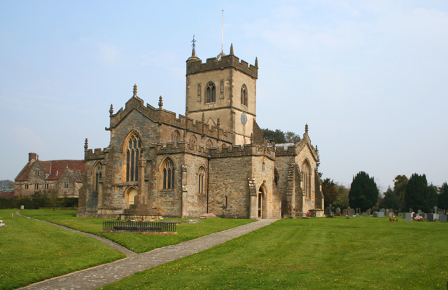
The Church of St Mary Magdalene has 12th-century origins. It has been designated by English Heritage as a Grade I listed building.[10]
Sport
Ditcheat is home to the stables operated by Paul Nicholls, trainer of Cheltenham Gold Cup-winning horses Kauto Star and Denman.[11]
Notable people
- William Alleine (1614–1677) -minister
References
- ^ "Parish Population Statistics". ONS Census 2001. Somerset County Council. http://www.webcitation.org/5lRyC5ccr. Retrieved 2009-12-14.
- ^ Havinden, Michael. The Somerset Landscape. The making of the English landscape. London: Hodder and Stoughton. p. 97. ISBN 0340201169.
- ^ "Somerset Hundreds". GENUKI. http://www.genuki.org.uk/big/eng/SOM/Miscellaneous/. Retrieved 22 October 2011.
- ^ "Ansford Bridge". Images of England. http://www.imagesofengland.org.uk/Details/Default.aspx?id=268278. Retrieved 2008-03-20.
- ^ "Boulter's Bridge". Images of England. http://www.imagesofengland.org.uk/Details/Default.aspx?id=268279. Retrieved 2008-03-20.
- ^ "Boulters Bridge". Listed Buildings Online. English Heritage. http://www.heritagegateway.org.uk/Gateway/Results_Single.aspx?uid=268279&resourceID=5. Retrieved 2 January 2011.
- ^ "Ditcheat House, or Ditcheat Manor". Images of England. http://www.imagesofengland.org.uk/Details/Default.aspx?id=268297. Retrieved 2008-03-20.
- ^ A Vision of Britain Through Time : Shepton Mallet Rural District
- ^ "The Priory". Images of England. http://www.imagesofengland.org.uk/Details/Default.aspx?id=268306. Retrieved 2008-03-20.
- ^ "Church of St Mary Magdalene". Images of England. http://www.imagesofengland.org.uk/Details/Default.aspx?id=268292. Retrieved 2008-03-20.
- ^ "Gold Cup winner in village parade". BBC News. 14 March 2009. http://news.bbc.co.uk/1/hi/england/somerset/7943837.stm. Retrieved 15 March 2009.
External links
Towns, villages and hamlets in the Mendip district of Somerset, England  Ashwick · Baltonsborough · Batcombe · Beckington · Berkley · Binegar · Buckland Dinham · Chewton Mendip · Chilcompton · Coleford · Cranmore · Croscombe · Ditcheat · Doulting · Downhead · East Lydford · East Pennard · Emborough · Evercreech · Frome · Glastonbury · Godney · Great Elm · Hemington · Holcombe · Kilmersdon · Lamyat · Leigh-on-Mendip · Litton · Lullington · Lydford-on-Fosse · Meare · Mells · Milton Clevedon · North Wootton · Norton St Philip · Nunney · Pilton · Priddy · Pylle · Rode · Rodney Stoke · Rudge · Selwood · Sharpham · Shepton Mallet · St Cuthbert Out · Stoke St Michael · Ston Easton · Stratton-on-the-Fosse · Street · Tellisford · Trudoxhill · Upton Noble · Walton · Wanstrow · Wells · West Bradley · West Lydford · West Pennard · Westbury-sub-Mendip · Whatley · Witham Friary · Wookey · Wookey HoleCategories:
- Villages in Mendip
- Civil parishes in Somerset

Wikimedia Foundation. 2010.