- Whatley, Mendip
-
Coordinates: 51°13′46″N 2°23′04″W / 51.2295°N 2.3845°W
Whatley 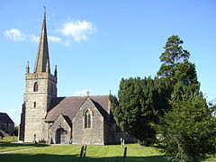
Church of the Holy Trinity
 Whatley
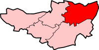
Whatley shown within SomersetPopulation 272 [1] OS grid reference ST731479 District Mendip Shire county Somerset Region South West Country England Sovereign state United Kingdom Post town FROME Postcode district BA11 Dialling code 01373 Police Avon and Somerset Fire Devon and Somerset Ambulance South Western EU Parliament South West England UK Parliament Somerton and Frome List of places: UK • England • Somerset For other uses, see Whatley (disambiguation).Whatley is a small rural village and civil parish near Frome in the English county of Somerset.
Contents
History
According to Robinson, it was called Watelei in the Domesday Book of 1086, when the tenants of the Abbot of Glastonbury Abbey were Walter Hussey and John the Usher. He suggests the village name means 'The wet meadow' from the Old English woet and leah.[2]
The parish was part of the hundred of Frome.[3]
The village gives its name to Whatley Quarry, which lies to the north-west of the village at grid reference ST731479 and is said to be one of the largest in Europe. It is owned by Hanson plc and has been the object of protests against its impact on the environment.
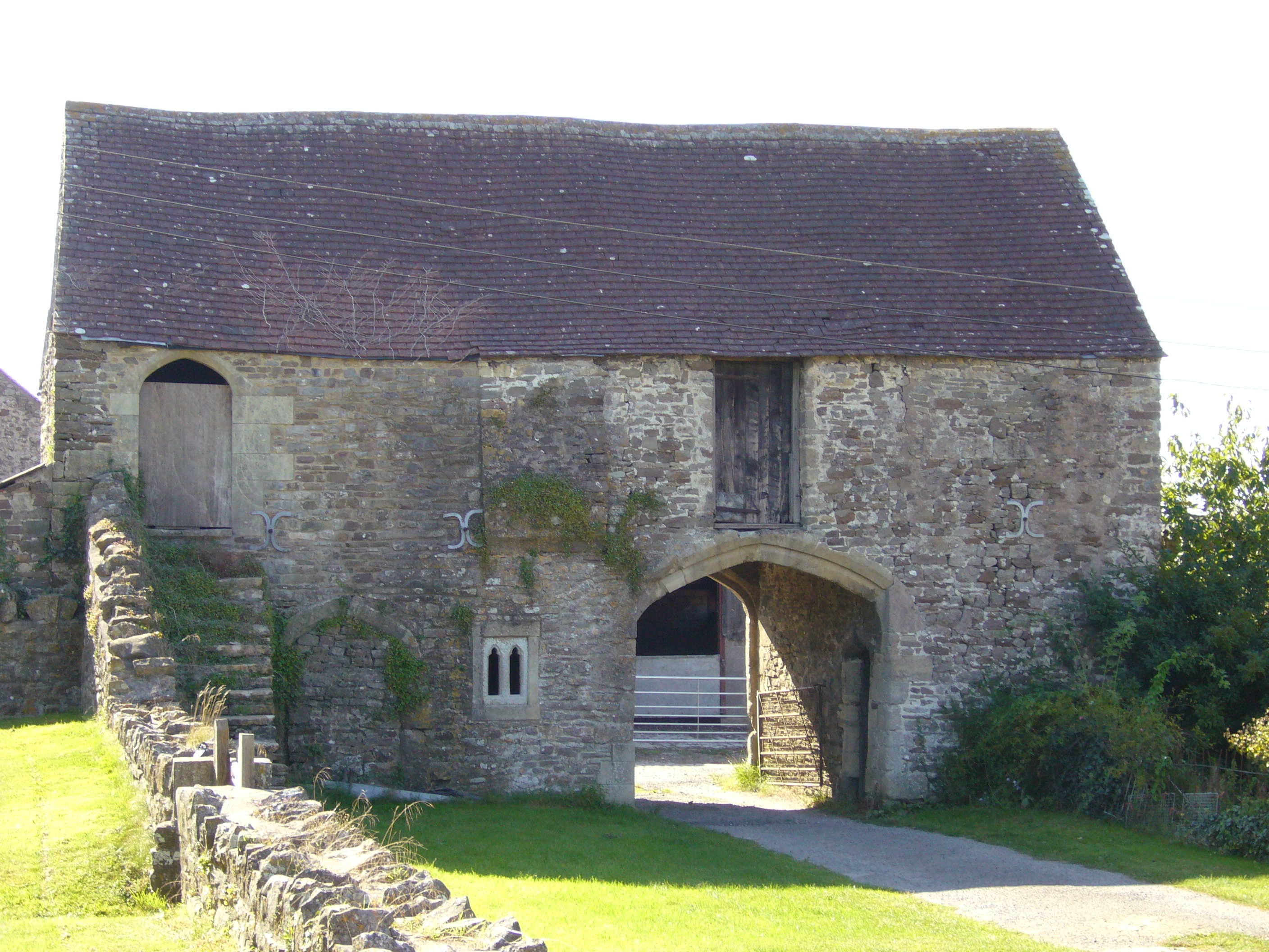
The gatehouse at Manor farm was built around 1500 and is a Grade I listed building.[4]
The hamlet of Lower Whatley is to the south of the village.
The hamlet of Chantry lies 1 mile to the west. It is one of the Thankful Villages which suffered no casualties in the First World War. Chantry Park is Grade II* listed: The Chantry is a neoclassical villa built c. 1825 to the design of Bath architect John Pinch the elder.[5] The Chantry Estate and school were established by the family of James Fussell, an iron magnate operating the Old Ironstone Works, Mells in Vallis Vale between Mells and Great Elm.[6]
Governance
The parish council has responsibility for local issues, including setting an annual precept (local rate) to cover the council’s operating costs and producing annual accounts for public scrutiny. The parish council evaluates local planning applications and works with the local police, district council officers, and neighbourhood watch groups on matters of crime, security, and traffic. The parish council's role also includes initiating projects for the maintenance and repair of parish facilities, as well as consulting with the district council on the maintenance, repair, and improvement of highways, drainage, footpaths, public transport, and street cleaning. Conservation matters (including trees and listed buildings) and environmental issues are also the responsibility of the council.
The village falls within the Non-metropolitan district of Mendip, which was formed on April 1, 1974 under the Local Government Act 1972, having previously been part of Frome Rural District,[7] which is responsible for local planning and building control, local roads, council housing, environmental health, markets and fairs, refuse collection and recycling, cemeteries and crematoria, leisure services, parks, and tourism.
Somerset County Council is responsible for running the largest and most expensive local services such as education, social services, libraries, main roads, public transport, policing and fire services, trading standards, waste disposal and strategic planning.
It is also part of the Somerton and Frome county constituency represented in the House of Commons of the Parliament of the United Kingdom. It elects one Member of Parliament (MP) by the first past the post system of election, and part of the South West England constituency of the European Parliament which elects seven MEPs using the d'Hondt method of party-list proportional representation.
Religious sites
The Church of the Holy Trinity dates from 1844–46 by George Gilbert Scott and William Moffatt, with further work by William George Brown of Frome, for James Fussell, who owned the local iron works. It is a Grade I listed building.[8] In 1858 Richard William Church was amongst the clergy of the church. The precise location of Whatley church is 51°13′37.52″N 2°22′56.17″W / 51.2270889°N 2.3822694°W.
Gallery of images
-
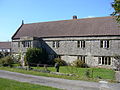
Old house near the church
-
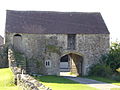
Old gatehouse/barn near the church
References
- ^ "Parish Population Statistics". ONS Census 2001. Somerset County Council. http://www.webcitation.org/5lRyC5ccr. Retrieved 2009-12-14.
- ^ Robinson, Stephen (1992). Somerset Place Names. Wimborne, Dorset: The Dovecote Press Ltd. ISBN 1874336032.
- ^ "Somerset Hundreds". GENUKI. http://www.genuki.org.uk/big/eng/SOM/Miscellaneous/. Retrieved 8 October 2011.
- ^ "Gatehouse to West of Manor Farmhouse". Images of England. English Heritage. http://www.imagesofengland.org.uk/details/default.aspx?id=266916. Retrieved 2009-05-28.
- ^ "The Chantry". Images of England. http://www.imagesofengland.org.uk/details/default.aspx?id=266899. Retrieved 2006-11-25.
- ^ Mark Adler (December 2010). "When Fussells had the edge". Mendip Times 6 (7): 89.
- ^ A Vision of Britain Through Time : Frome Rural District
- ^ "Church of the Holy Trinity". Images of England. http://www.imagesofengland.org.uk/details/default.aspx?id=266897. Retrieved 2006-11-25.
External links
Towns, villages and hamlets in the Mendip district of Somerset, England  Ashwick · Baltonsborough · Batcombe · Beckington · Berkley · Binegar · Buckland Dinham · Chewton Mendip · Chilcompton · Coleford · Cranmore · Croscombe · Ditcheat · Doulting · Downhead · East Lydford · East Pennard · Emborough · Evercreech · Frome · Glastonbury · Godney · Great Elm · Hemington · Holcombe · Kilmersdon · Lamyat · Leigh-on-Mendip · Litton · Lullington · Lydford-on-Fosse · Meare · Mells · Milton Clevedon · North Wootton · Norton St Philip · Nunney · Pilton · Priddy · Pylle · Rode · Rodney Stoke · Rudge · Selwood · Sharpham · Shepton Mallet · St Cuthbert Out · Stoke St Michael · Ston Easton · Stratton-on-the-Fosse · Street · Tellisford · Trudoxhill · Upton Noble · Walton · Wanstrow · Wells · West Bradley · West Lydford · West Pennard · Westbury-sub-Mendip · Whatley · Witham Friary · Wookey · Wookey HoleCategories:
- Villages in Mendip
- Civil parishes in Somerset
-


Wikimedia Foundation. 2010.