- Mendip transmitting station
-
Mendip 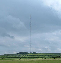
The Mendip UHF Television MastHeight of mast 293 metres (961 ft) Grid reference ST564488 Built 1967 BBC region BBC West ITV region ITV West 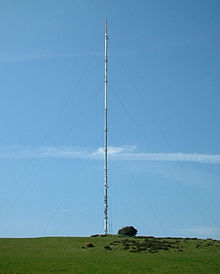 The Mendip UHF Television Mast
The Mendip transmitting station is a broadcasting and telecommunications facility, situated on the summit of Pen Hill, part of the Mendip Hills range in Somerset, England, at 305 metres (1,001 ft) above sea level. The station is located in St Cuthbert Out civil parish in Mendip district. It includes a 281.6 metres (924 ft) tall mast, which was built in 1967 and weighs around 500 tonnes, and is the tallest structure in the southwestern England. The mast currently broadcasts digital television, FM analogue radio and DAB digital radio, and had broadcast analogue colour television from 1967 until 2010.
Until 2008 a GRP aerial cylinder, which contains the analogue television transmitting antennas, was located at the top of the mast, bringing the total height of the structure to 305 metres (1,001 ft). With a mean height of 596 metres (1,955 ft) above sea level, the analogue television antennas were amongst the highest in the UK. The analogue television antennas were removed in 2010, the original antenna cylinder being replaced with a new antenna assembly, ready for digital switchover in 2010. The new assembly is slightly shorter than the previous cylinder causing the overall mast height to be reduced from 305 metres (1,001 ft) to 293 metres (961 ft).[1]
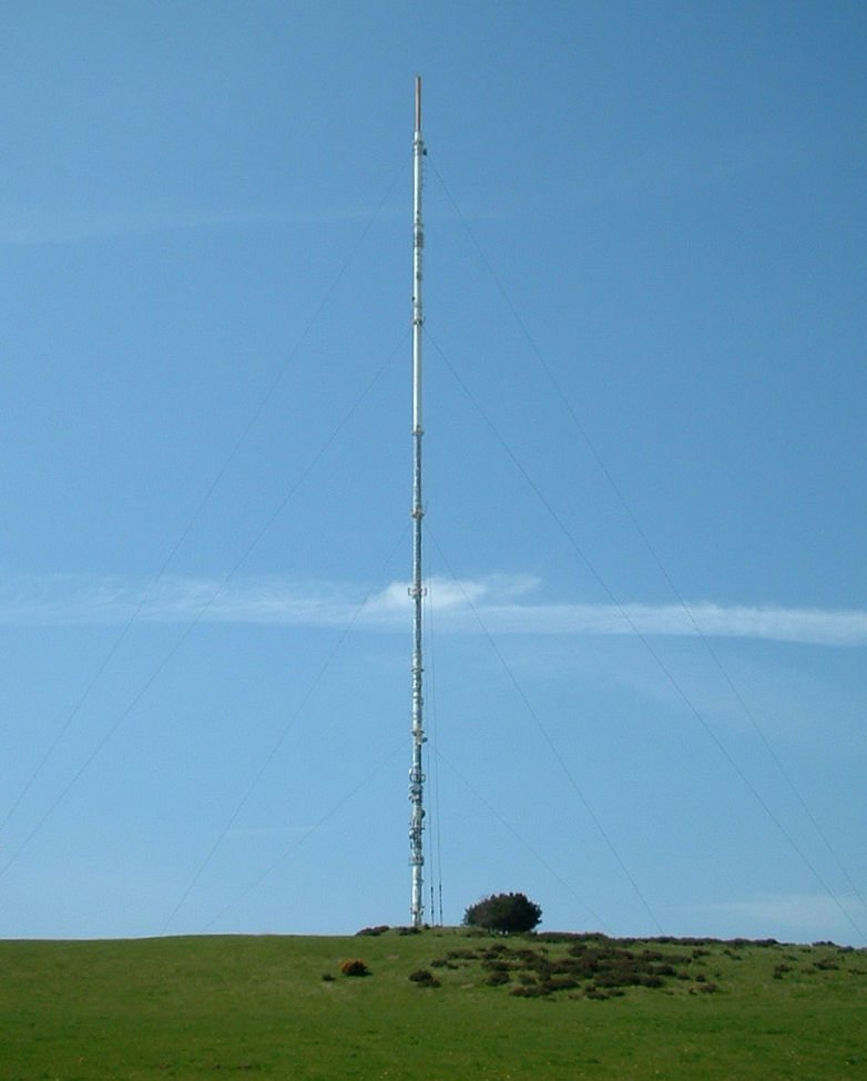
There are around twelve red aircraft warning lamps (six sets of two lights) up the mast with two lights on top. The lights were upgraded in February 2007[2] to comply with CAA 2000 Air Navigation Order, designed to prevent low flying aircraft from hitting the mast in adverse weather conditions.
The station is owned and operated by Arqiva (which acquired the National Grid Wireless, previously Crown Castle.)
The mast was entirely repainted during 2007.
The mast has become a well known and loved Mendip landmark and can provide some spectacular images when engulfed in fog or cloud or illuminated in full sunlight. It also provides a unique method of identifying the hills from a distance.
Contents
Television
Mendip was set up as a C/D group transmitter when it entered service with analogue PAL transmissions. In July 2007, Ofcom confirmed that it would remain a C/D group transmitter at digital switchover. The mast broadcasts digital television over a large area of the west of England, including Somerset, Wiltshire, North Somerset, Bath and North-East Somerset, Bristol, South Gloucestershire and Southern Gloucestershire. The station also covers the coastal areas of south east Wales, and in the days of analogue TV, many households used it in preference to their more local station, Wenvoe. This is because prior to the digital switchover, Mendip carried Channel 4 and Channel 5, whereas Wenvoe only carried S4C, which broadcast a lot of Welsh language programming. Indeed many houses still have aerials directed at both stations. Power on analogue transmissions was 500 kW (erp) on channels 1 to 4 but only 126 kW on Channel 5. The latter was transmitted outside of the original C/D grouping of the transmitter but most people in reasonable signal areas could receive it anyway, see aerial gain curves. All 6 digital multiplexes were transmitted at 10 kW until switchover in 2010 when the power on the "BBC A", "BBC B/HD" and "D3&4" multiplexes was boosted to 100 kW. In 2011, SDN was boosted to 50 kW and in 2012 the remaining two Arqiva multiplexes will be boosted to 50 kW too. Mendip's population coverage is around 1.5 million, although some homes in the immediate vicinity, such as those in Cheddar are unable to receive a signal due to being in the shadow of the Mendip Hills and therefore have to depend on local relays.
Radio
Mendip broadcasts FM (analogue VHF) radio for BBC Somerset and the Severn Estuary Regional service of Galaxy 101 (now known as Kiss 101). It transmits high power Digital Audio Broadcasting (DAB) signals for Digital One and BBC National DAB multiplexes, as well as a lower power local service to Glastonbury for MXR Severn Estuary. These three multiplexes carry approximately ten digital radio stations each. An additional DAB multiplex, MuxCo Somerset, was awarded a licence in 2008 to broadcast local and national services to Somerset. As of 2010, it is expected that MuxCo Somerset will use the Mendip station, though transmissions have yet to commence.[3]
Output
Radio
Analogue
Frequency kW[4] Service 95.5 MHz 5 BBC Somerset 101.0 MHz 40 Kiss 101 Digital
Frequency Block kW[5] Operator 222.064 MHz 11D 5 Digital One 225.648 MHz 12B 5 BBC National DAB 227.360 MHz 12C 0.75 MXR Severn Estuary Television
Analogue
Mendip radiated all 5 analogue services until the digital switchover between 24 March - 7 April 2010.
Frequency UHF kW Service 599.25 MHz 37 126 Channel 5 735.25 MHz 54 500 Channel 4 767.25 MHz 58 500 BBC One 791.25 MHz 61 500 ITV1 815.25 MHz 64 500 BBC Two On 24 March 2010 BBC Two was switched off on UHF 64 and ITV1 was switched from UHF 61 for its final weeks of service. UHF 61 was then used to carry the digital BBC A multiplex at full power (100 kW), the first digital multiplex to reach full power from the site.
Frequency UHF kW Service 599.25 MHz 37 126 Channel 5 735.25 MHz 54 500 Channel 4 767.25 MHz 58 500 BBC One 815.25 MHz 64 500 ITV1 Digital switchover was completed on 7 April 2010. All analogue TV was discontinued permanently from this date. See below for the initial configuration of the digital TV transmissions.
Digital
Digital terrestrial television was first transmitted from the Mendip mast from 15 November 1998 using the frequency gaps between the analogue TV broadcasts. In order to limit possible interference to the analogue transmissions, power output on the digital multiplexes was comparatively very low. Until the start of the Digital Switchover process on 28 March 2010 the frequencies were:
Frequency UHF kW Operator 746.2 MHz 55+ 10 Digital 3&4 (Mux 2) 754.2 MHz 56+ 10 Arqiva (Mux C) 778.2 MHz 59+ 10 BBC (Mux 1) 802.2 MHz 62+ 10 SDN (Mux A) 826.2 MHz 65+ 10 BBC (Mux B) 842.0 MHz 67 10 Arqiva (Mux D) On 28 March 2010, Multiplex 1 on UHF 59+ was closed and replaced by BBC A on UHF 61 (which had just been vacated by analogue ITV1). BBC A was transmitted at full power (100kW) and in 64QAM, 8k carriers mode from the start. Until 7 April 2010, the frequency allocation was now:
Frequency UHF kW Operator 746.2 MHz 55+ 10 Digital 3&4 (Mux 2) 754.2 MHz 56+ 10 Arqiva (Mux C) 794.0 MHz 61 100 BBC A 802.2 MHz 62+ 10 SDN (Mux A) 826.2 MHz 65+ 10 BBC (Mux B) 842.0 MHz 67 10 Arqiva (Mux D) Following the completion of analogue TV shutdown on 7 April 2010, Mendip transmitted all of its higher powered multiplexes at 100 kW. From this date until the second-stage switchover of 27 September 2011 the frequency allocation was:
Frequency UHF kW Operator 738.0 MHz 54 100 Digital 3&4 754.2 MHz 56+ 10 Arqiva A 770.0 MHz 58 100 BBC B 794.0 MHz 61 100 BBC A 802.2 MHz 62+ 10 SDN 842.0 MHz 67 26 Arqiva B With the completion of digital switchover at Oxford, all multiplexes could be moved to their final channel allocations with the exception of Arqiva A. SDN increased to full power output. From 28 September 2011 to 28 March 2012 the current frequency allocation is:
Frequency UHF kW Operator 690.0 MHz 48 50 SDN 722.0 MHz 52 26† Arqiva B 738.0 MHz 54 100 Digital 3&4 770.0 MHz 58 100 BBC B 794.0 MHz 61 100 BBC A 842.0 MHz 67†† 12.5† Arqiva A † Power level expected to be increased to 50kW in March 2012 after completion of digital switchover at Salisbury.
†† Temporary parking channel. Final channel TBC, awaiting completion of digital switchover at Salisbury.[6]See also
- List of masts
- List of radio stations in the United Kingdom
- List of tallest buildings and structures in Great Britain
References
- ^ Planning Application Details
- ^ http://www.cheddarvalleygazette.co.uk/displayNode.jsp?nodeId=216909&command=displayContent&sourceNode=216903&contentPK=16636764&moduleName=InternalSearch&formname=filtersearch
- ^ "South West England and Wales". Frequency Finder. http://frequencyfinder.org.uk/DAB_SW_map1.pdf. Retrieved 23 August 2011.
- ^ Radio Listeners Guide 2010
- ^ Radio Listeners Guide 2010
- ^ 'Digital UK' Press Release
External links
- The Transmission Gallery: photographs, coverage maps and information
- Pictures and info on Mendip including co-receivable transmitters
- Entry at skyscraperpage.com
- Mendip Transmitter at thebigtower.com
Mendip Hills Settlements: Ashwick · Axbridge · Banwell · Bishop Sutton · Blagdon · Bleadon · Burrington · Charterhouse · Cheddar · Chewton Mendip · Compton Bishop · Compton Martin · Cross · Draycott · East Harptree · Easton · Hinton Blewett · Hutton · Leigh-on-Mendip · Litton · Oakhill · Priddy · Rodney Stoke · Rowberrow · Sandford · Shepton Mallet · Shipham · Ubley · Webbington · Wells · West Harptree · Westbury-sub-Mendip · Winscombe · Wookey HoleRivers and lakes: River Axe · Cheddar Yeo · River Chew · River Yeo · Lox Yeo River · Blagdon Lake · Cheddar Reservoir · Chew Valley Lake · Litton ReservoirsHills Axbridge Hill · Black Down · Bleadon Hill · Burledge Hill · Crook Peak · Fry's Hill · Pen Hill · Purn Hill · Shute Shelve Hill · Wavering DownCaves and gorges: Attborough Swallet · Aveline's Hole · Axbridge Ochre Mine · Banwell Caves · Banwell Ochre Caves · Burrington Combe · Charterhouse Cave · Cheddar Gorge · Compton Martin Ochre Mine · Cox's Cave · Eastwater Cavern · Ebbor Gorge · Fairy Cave Quarry · GB Cave · Goatchurch Cavern · Gough's Cave · Hunter's Hole · Lamb Leer · Longwood Swallet · Pierre's Pot · Priddy Caves · Rod's Pot · Shatter Cave · Shute Shelve Cavern · Sidcot Swallet · St Cuthbert's Swallet · St. Dunstan's Well Catchment · Stoke Lane Slocker · Swildon's Hole · Thrupe Lane Swallet · Tyning's Barrow Swallet · Upper Flood Swallet · W/L Cave · Wookey Hole CavesQuarries: Batts Combe · Callow Rock · Cloford · Cloud · Colemans · Cook's Wood · Doulting Stone · Dulcote · Emborough · Fairy Cave · Gurney Slade · Halecombe · Hobbs · Holwell · Moon's Hill · Torr Works · Viaduct · Whatley · Windsor HillSSSIs: Asham Wood · Axbridge Hill and Fry's Hill · Banwell Caves · Banwell Ochre Caves · Barns Batch Spinney · Blagdon Lake · Bleadon Hill · Brimble Pit and Cross Swallet Basins · Burledge Hill · Burrington Combe · Chancellor's Farm · Cheddar Complex · Cheddar Reservoir · Cheddar Wood · Chew Valley Lake · Cloford Quarry · Compton Martin Ochre Mine · Cook's Wood Quarry · Crook Peak to Shute Shelve Hill · Dolebury Warren · Draycott Sleights · Ebbor Gorge · Emborough Quarries · Harptree Combe · Hobbs Quarry · Holwell Quarries · Kingdown and Middledown · Lamb Leer · Priddy Caves · Priddy Pools · Perch · Rodney Stoke · St. Dunstan's Well Catchment · Sandpit Hole and Bishop's Lot · Shiplate Slait · Viaduct Quarry · Windsor Hill Quarry · Wurt Pit and Devil's PunchbowlHistory Transport Councils: Surrounding areas: Categories:- Mendip Hills
- Buildings and structures in Somerset
- Radio masts
- Transmitter sites in the United Kingdom

Wikimedia Foundation. 2010.