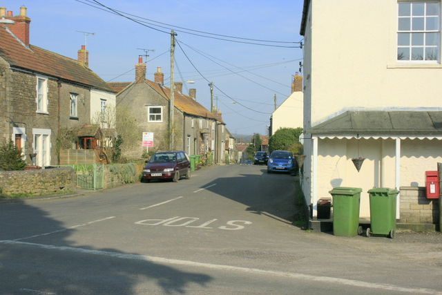
- Wanstrow
-
Coordinates: 51°10′19″N 2°24′32″W / 51.172°N 2.409°W
Wanstrow 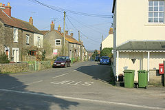

 Wanstrow
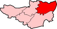
Wanstrow shown within SomersetPopulation 446 [1] OS grid reference ST715415 District Mendip Shire county Somerset Region South West Country England Sovereign state United Kingdom Post town SHEPTON MALLET Postcode district BA4 Dialling code 01749 Police Avon and Somerset Fire Devon and Somerset Ambulance South Western EU Parliament South West England UK Parliament Somerton and Frome List of places: UK • England • Somerset Wanstrow is a village and civil parish 6 miles (9.7 km) south west of Frome in the Mendip district of Somerset, England. The parish includes the village of Cloford.
Contents
History
The name of the village comes from the Old English and means Waendel's tree.[2]
The Bishop of Wells had an estate in the parish before the Norman Conquest which supported a prebend at Wells Cathedral. The estate was split in two with one first called East Wanstrow, and later Church Wanstrow supporting Wells Cathedral and West Wanstrow, Wanstrow Rogers and Wanstrow Buller was given by Hugh Sexey to support the hospital at Bruton.[2]
The parish was part of the hundred of Frome.[3]
The village was involved in the production of coarse earthenware, using clay dug on Wanstrow Common, until 1826.[2]
Governance
The parish council has responsibility for local issues, including setting an annual precept (local rate) to cover the council’s operating costs and producing annual accounts for public scrutiny. The parish council evaluates local planning applications and works with the local police, district council officers, and neighbourhood watch groups on matters of crime, security, and traffic. The parish council's role also includes initiating projects for the maintenance and repair of parish facilities, as well as consulting with the district council on the maintenance, repair, and improvement of highways, drainage, footpaths, public transport, and street cleaning. Conservation matters (including trees and listed buildings) and environmental issues are also the responsibility of the council.
The village falls within the Non-metropolitan district of Mendip, which was formed on April 1, 1974 under the Local Government Act 1972, having previously been part of Frome Rural District,[4] who are responsible for local planning and building control, local roads, council housing, environmental health, markets and fairs, refuse collection and recycling, cemeteries and crematoria, leisure services, parks, and tourism.
Somerset County Council are responsible for running the largest and most expensive local services such as education, social services, libraries, main roads, public transport, policing and fire services, trading standards, waste disposal and strategic planning.
It is also part of the Somerton and Frome county constituency represented in the House of Commons of the Parliament of the United Kingdom. It elects one Member of Parliament (MP) by the first past the post system of election, and part of the South West England constituency of the European Parliament which elects seven MEPs using the d'Hondt method of party-list proportional representation.
Geography
Cloford Quarry is a 39.92 hectare geological Site of Special Scientific Interest and Geological Conservation Review site important for the exposures of sediments of Triassic and Jurassic age which occur in major fissures within the Carboniferous Limestone. No other site in Britain shows such a variety and abundance of sediment-infilled fissures of this age.[5] Cloford Quarry was the main location used for the planet Lakertya in the Doctor Who story Time and the Rani.
Leighton Road Cutting is another geological Site of Special Scientific Interest between East Cranmore and Cloford which provides exposure of a series of early Jurassic limestones, of Lower Lias age, which are the only known outcrops of these particular rocks to occur in a normal horizontally-bedded sequence in the Mendips.[6]
Transport
Wanstrow railway station was a small station on the East Somerset Railway which opened in 1858, but the railway company did not build a station at Wanstrow. Local people paid for a small building, and a platform was built later. The station opened on 1 January 1860. It closed to passenger traffic with the rest of the line on 9 September 1963.
Landmarks
The manor house was built in the 17th century and has been designated as a Grade II* listed building.[7]
Religious sites
In Cloford there is a Norman church, dedicated to St Mary, dates from the 15th century and was rebuilt in 1856. It is Grade II* listed.[8]
In Wanstrow itself there is another 15th century church also dedicated to St Mary.[9]
Notable residents
Wanstrow is the birthplace of Joseph Harding, the "father of Cheddar Cheese"
References
- ^ "Parish Population Statistics". ONS Census 2001. Somerset County Council. http://www.webcitation.org/5lRyC5ccr. Retrieved 2009-12-14.
- ^ a b c Bush, Robin (1994). Somerset: The Complete Guide. Dovecote Press. p. 212. ISBN 1874336261.
- ^ "Somerset Hundreds". GENUKI. http://www.genuki.org.uk/big/eng/SOM/Miscellaneous/. Retrieved 8 October 2011.
- ^ A Vision of Britain Through Time : Frome Rural District
- ^ "Citation Sheet" (PDF). English Nature. http://www.english-nature.org.uk/citation/citation_photo/1003907.pdf. Retrieved 2008-02-01.
- ^ English Nature citation sheet for the site . Retrieved 10 August 2006.
- ^ "Manor House and Manor Farmhouse". Images of England. English Heritage. http://www.imagesofengland.org.uk/Details/Default.aspx?id=266875. Retrieved 2009-02-08.
- ^ "Church of St Mary (Cloford)". Images of England. http://www.imagesofengland.org.uk/details/default.aspx?id=266881. Retrieved 2008-02-01.
- ^ "Church of St Mary (Wanstrow)". Images of England. http://www.imagesofengland.org.uk/details/default.aspx?id=266870. Retrieved 2006-11-25.
External links
 Media related to Wanstrow at Wikimedia Commons
Towns, villages and hamlets in the Mendip district of Somerset, England  Ashwick · Baltonsborough · Batcombe · Beckington · Berkley · Binegar · Buckland Dinham · Chewton Mendip · Chilcompton · Coleford · Cranmore · Croscombe · Ditcheat · Doulting · Downhead · East Lydford · East Pennard · Emborough · Evercreech · Frome · Glastonbury · Godney · Great Elm · Hemington · Holcombe · Kilmersdon · Lamyat · Leigh-on-Mendip · Litton · Lullington · Lydford-on-Fosse · Meare · Mells · Milton Clevedon · North Wootton · Norton St Philip · Nunney · Pilton · Priddy · Pylle · Rode · Rodney Stoke · Rudge · Selwood · Sharpham · Shepton Mallet · St Cuthbert Out · Stoke St Michael · Ston Easton · Stratton-on-the-Fosse · Street · Tellisford · Trudoxhill · Upton Noble · Walton · Wanstrow · Wells · West Bradley · West Lydford · West Pennard · Westbury-sub-Mendip · Whatley · Witham Friary · Wookey · Wookey HoleCategories:
- Villages in Mendip
- Civil parishes in Somerset

Wikimedia Foundation. 2010.