- Nixes Mate
-
Nix's Mate Daybeacon
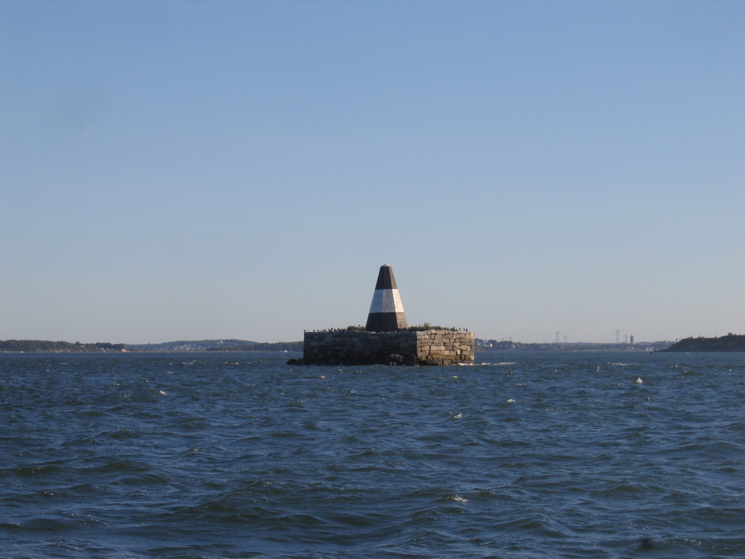
 Pyramid beacon on Nixes Mate at 1 hour after high tide

Location: Nubble Channel, The Narrows, Boston Harbor, Boston, Massachusetts Coordinates: 42°19′53.5″N 70°56′39.3″W / 42.331528°N 70.94425°WCoordinates: 42°19′53.5″N 70°56′39.3″W / 42.331528°N 70.94425°W Area: less than one acre Built: 1834[2] Governing body: U.S. Coast Guard NRHP Reference#: 04000189
[1]Added to NRHP: March 18, 2004 Nixes Mate, also known as Nixes Island, Nix's Mate and Nick's Mate, is one of the smaller islands in the Boston Harbor Islands National Recreation Area. The island lies about 5 nm from downtown Boston and about 0.6 nm east of Long Island Head Light. The island covers and uncovers with the tide.[3] A prominent black and white stucco covered wood pyramidal beacon, resting atop a granite base,[4] reaches a height of approximately 20 feet (6.1 m).[5] The base was erected by the Boston Marine Society in 1805. By 2001, the daymark was in poor condition. The Coast Guard, which is responsible for it, announced that it would be replaced, but following public outcry they rebuilt it instead, in 2003.[4] The island is not open to the public.[5] It is described in the Light List as "Nixes Mate: black, white band midway of height, octagonal pyramid on square granite base", Light List number 1-11450.[6]
In 1636, Nix's Mate was granted to John Gallop, a harbor pilot who lived on nearby Gallops Island and used the then 12-acre (49,000 m2) island for grazing his sheep. Ship's ballast was quarried from the island during the 17th century, followed by slate in the 18th century, resulting in today's much smaller island. In 1726, upon the arrest of pirate chief William Fly, officials brought him to Boston where he was executed. His body was then gibbetted on Nixes Mate to serve as a warning to sailors not to turn to piracy. Before Fly's execution, he famously scolded the hangman for incorrectly securing his noose, then re-tied it himself. His body, as well as those of two other pirates, is buried on the island.[5]
Nixes Mate was added to the National Register of Historic Places as Nix's Mate Daybeacon on March 18, 2004, reference number 04000189.[1]
References
- ^ a b "National Register Information System". National Register of Historic Places. National Park Service. 2009-03-13. http://nrhp.focus.nps.gov/natreg/docs/All_Data.html.
- ^ According to the National Register of Historic Places. 1805 according to Rowlett.
- ^ Chart 13270: Boston Harbor 1:25,000. NOAA. 2006.
- ^ a b Rowlett, Russ (2009-09-07). "Lighthouses of the United States: Northern Massachusetts". The Lighthouse Directory. University of North Carolina at Chapel Hill. http://www.unc.edu/~rowlett/lighthouse/ma.htm.
- ^ a b c "Nixes Mate Factsheet". Boston Harbor Islands Partnership. Archived from the original on September 27, 2007. http://web.archive.org/web/20070927224525/http://www.bostonislands.org/factsheet_template.asp?rsIslands__MMColParam=nima. Retrieved January 8, 2011.
- ^ (PDF) Light List, Volume I, Atlantic Coast, St. Croix River, Maine to Shrewsbury River, New Jersey. Light List. United States Coast Guard. 2009. p. 95. http://www.navcen.uscg.gov/pdf/lightLists/LightList%20V1.pdf.
U.S. National Register of Historic Places Topics Lists by states Alabama • Alaska • Arizona • Arkansas • California • Colorado • Connecticut • Delaware • Florida • Georgia • Hawaii • Idaho • Illinois • Indiana • Iowa • Kansas • Kentucky • Louisiana • Maine • Maryland • Massachusetts • Michigan • Minnesota • Mississippi • Missouri • Montana • Nebraska • Nevada • New Hampshire • New Jersey • New Mexico • New York • North Carolina • North Dakota • Ohio • Oklahoma • Oregon • Pennsylvania • Rhode Island • South Carolina • South Dakota • Tennessee • Texas • Utah • Vermont • Virginia • Washington • West Virginia • Wisconsin • WyomingLists by territories Lists by associated states Other Categories:- Lighthouses on the National Register of Historic Places in Massachusetts
- Boston Harbor
- Lighthouses in Boston, Massachusetts

Wikimedia Foundation. 2010.