- Cleveland East Ledge Light
-
Cleveland East Ledge Light 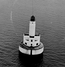
Location Falmouth, Massachusetts Year first constructed 1940-1943 Automated 1978 Foundation Concrete and rock caisson Construction Reinforced concrete Tower shape Cylindrical on square dwelling Markings / pattern White tower
red-brown caisson
black lanternFocal height 74 ft (23m) Original lens 4th order Fresnel lens Current lens 190mm Range 15 nm Characteristic Fl W 10s Fog signal Horn, one every 15s Racon "C" (Charlie) Admiralty number J0502 ARLHS number USA-179 USCG number 1-16080 Cleveland Ledge Light Station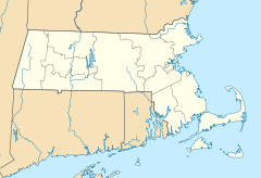

Nearest city: Falmouth, Massachusetts Coordinates: 41°37′51.470″N 70°41′39.046″W / 41.6309639°N 70.69417944°WCoordinates: 41°37′51.470″N 70°41′39.046″W / 41.6309639°N 70.69417944°W Area: less than one acre Built: 1940 Architectural style: Moderne, Art Moderne Governing body: US Coast Guard MPS: Lighthouses of Massachusetts TR NRHP Reference#: 87001462
[4]Added to NRHP: June 15, 1987 Cleveland East Ledge Light is a historic lighthouse in Falmouth, Massachusetts.
The lighthouse was built in 1940-1943. The state of Massachusetts began the project, but turned it over to the Coast Guard in 1941, which, after delays caused by the war, completed it in 1943.[2]
It sits in shallow water on the eastern of the two halves of Cleveland Ledge, which is said to have been named for President Grover Cleveland because he used to fish in the area. It marks the east side of the beginning of the dredged channel leading to the Cape Cod Canal and is the first fixed mark when going northbound through the canal. As it is an important mark in an area subject to fog, it has a racon showing the letter "C".[1]
It was added to the National Register of Historic Places as Cleveland Ledge Light Station in 1987.
References
- ^ a b (PDF) Light List, Volume I, Atlantic Coast, St. Croix River, Maine to Shrewsbury River, New Jersey. Light List. United States Coast Guard. 2009. p. 143. http://www.navcen.uscg.gov/pdf/lightLists/LightList%20V1.pdf.
- ^ a b "Historic Light Station Information and Photography: Massachusetts". United States Coast Guard Historian's Office. http://www.uscg.mil/history/weblighthouses/LHMA.asp.
- ^ Rowlett, Russ (2009-12-16). "Lighthouses of the United States: Southeast Massachusetts". The Lighthouse Directory. University of North Carolina at Chapel Hill. http://www.unc.edu/~rowlett/lighthouse/ma2.htm.
- ^ "National Register Information System". National Register of Historic Places. National Park Service. 2009-03-13. http://nrhp.focus.nps.gov/natreg/docs/All_Data.html.
U.S. National Register of Historic Places Topics Lists by states Alabama • Alaska • Arizona • Arkansas • California • Colorado • Connecticut • Delaware • Florida • Georgia • Hawaii • Idaho • Illinois • Indiana • Iowa • Kansas • Kentucky • Louisiana • Maine • Maryland • Massachusetts • Michigan • Minnesota • Mississippi • Missouri • Montana • Nebraska • Nevada • New Hampshire • New Jersey • New Mexico • New York • North Carolina • North Dakota • Ohio • Oklahoma • Oregon • Pennsylvania • Rhode Island • South Carolina • South Dakota • Tennessee • Texas • Utah • Vermont • Virginia • Washington • West Virginia • Wisconsin • WyomingLists by territories Lists by associated states Other  Category:National Register of Historic Places •
  Portal:National Register of Historic Places
This article is about a historic property or district in Barnstable County, Massachusetts, that is listed on the National Register of Historic Places, is a stub. You can help Wikipedia by expanding it.