- Old Scituate Light
-
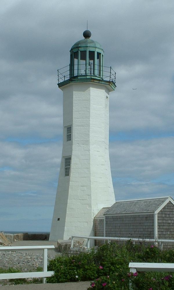
Old Scituate Light 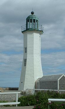
Old Scituate Light in Scituate Location Cedar Point, Scituate Harbor Year first lit 1811 Deactivated 1860–1994 Foundation Natural/emplaced Construction Granite/Brick Tower shape Octagonal Markings / pattern white with green lantern room roof Height 25 feet, 70 feet above sea level Original lens Pan Lamp 1811, Fresnel Lens 1855 Characteristic Flashing white 15s, Private Aid. USCG number 1-12275 Scituate Light

Location: Cedar Pt., Scituate, Massachusetts Coordinates: 42°12′17.1″N 70°42′57″W / 42.20475°N 70.71583°WCoordinates: 42°12′17.1″N 70°42′57″W / 42.20475°N 70.71583°W Area: 1.2 acres (0.49 ha) Built: 1811 Governing body: Local MPS: Lighthouses of Massachusetts TR NRHP Reference#: 87001490[3] Added to NRHP: June 15, 1987 Old Scituate Light also known simply as Scituate Light is an historic lighthouse located on Cedar Point in Scituate, Massachusetts.
- 1810, May: The Federal Government appropriated $4,000 for a lighthouse to be built at the entrance of Scituate Harbor.
- 1811, September 19: The lighthouse was completed two months ahead of schedule making it the 11th lighthouse in the United States.
- 1814, September, the War of 1812: Rebecca and Abagail Bates "The Lighthouse Army of Two" warded off an attack by British soldiers by playing their fife and drum loudly. The British retreated since they thought the sound came from the Scituate Town Militia.
- 1827: The height of the lighthouse was raised 15 feet and a new lantern room was added to improve the visibility of this lighthouse.
- 1850: Due to the construction of the Minot's Ledge Light the lighthouse was removed from service.
- 1852: The lighthouse was put back into service after a storm destroyed the first Minot's Ledge Light.
- 1855: The light received a new Fresnel lens.
- 1860: The light was once again removed from service after the second tower at Minot's Ledge was built, and over the next 60 years the lighthouse fell into disrepair.
- 1916: The lighthouse was put up for sale.
- 1917: The town of Scituate bought the lighthouse for $4,000.
- 1930: A new replica lantern was added
- 1960's: The lighthouse was still in a state of disrepair. The Scituate Historical Society appropriated $6,500 for repairs.
- 1988: The lighthouse was placed on the National Register of Historic Places.
- 1991, July: The lighthouse was relit with the light visible only from land.
- 1994: The light was made visible from sea as a private aid to navigation
Occasional tours are available from the Scituate Historical Society. The keeper's house is a private residence. The current keeper is Bob Gallagher, a History teacher at Marshfield High School in Marshfield, Massachusetts.
It was added to the National Register of Historic Places in 1987 as Scituate Light.
See also
- http://www.lighthouse.cc/scituate/history.html
- http://www.scituatehistoricalsociety.org/
- Blog of the current lighthouse keeper
References
- ^ (PDF) Light List, Volume I, Atlantic Coast, St. Croix River, Maine to Shrewsbury River, New Jersey. Light List. United States Coast Guard. 2009. p. 101. http://www.navcen.uscg.gov/pdf/lightLists/LightList%20V1.pdf.
- ^ "Historic Light Station Information and Photography: Massachusetts". United States Coast Guard Historian's Office. http://www.uscg.mil/history/weblighthouses/LHMA.asp.
- ^ "National Register Information System". National Register of Historic Places. National Park Service. 2009-03-13. http://nrhp.focus.nps.gov/natreg/docs/All_Data.html.
Categories:- Buildings and structures completed in 1811
- Lighthouses on the National Register of Historic Places in Massachusetts
- Lighthouses in Plymouth County, Massachusetts

Wikimedia Foundation. 2010.