- Marr
-
For other uses, see Marr (disambiguation).
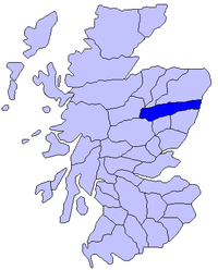
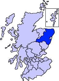
 Map of Scotland showing the present-day committee area of Marr
Marr is one of six committee areas in Aberdeenshire, Scotland, bordering Atholl, Badenoch, Gowrie, The Mearns, Banff and Buchan.[citation needed] It has a population of 34,038 (2001 Census). Someone from Marr is called a Màrnach in Scottish Gaelic.[citation needed]
To the west, the mountain environment of the Cairngorms National Park sustains a well-developed tourist industry based on heritage and outdoor pursuits. Forestry and livestock farming are key industries, particularly in remoter areas. Part of the area has qualified for EU financial assistance. To the east, Marr has experienced population growth due to its strong commuter links with the city of Aberdeen.[citation needed]
The committee area consists of three wards of Aberdeenshire council:
- Aboyne, Upper Deeside and Donside
- Banchory and Mid-Deeside
- Huntly, Strathbogie and Howe of Alford[1]
Between them the three wards elect 10 councillors to the sixty-eight member council.[2]
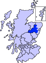
Historic district
 Map of Scotland showing the historic district of Marr
Marr is named after Mar, one of the historic districts of Scotland, extending from north of the Don southward to the Mounth. Like other such districts, it was under the rule of a mormaer in the Middle Ages. In the 12th century an earl (the Earl of Mar) took his place, but no definite succession of earls appears till the 13th century, nor is any connection established between them and the mormaers.
In the twelfth century Malcolm III introduced the office of sheriff to Scotland. He and his successors Edgar, Alexander I and in particular David I divided the country into sheriffdoms or shires.[3] Marr formed the larger portion of the shire of Aberdeen, which, as Aberdeenshire, in time became one of the counties of Scotland.[4]
References
- ^ "Area Committee Membership". Aberdeenshire Council. 18 February 2009. http://www.aberdeenshire.gov.uk/councillors/AreaCommitteeMembership.asp. Retrieved 2 August 2009.
- ^ "Councillors". Aberdeenshire Council. 29 April 2009. http://www.aberdeenshire.gov.uk/councillors/index.asp. Retrieved 2 August 2009.
- ^ Wallace, James (1890). The Sheriffdom of Clackmannan. A sketch of its history with a list of its sheriffs and excerpts from the records of court compiled from public documents and other authorities with preparatory notes on the office of Sheriff in Scotland, his powers and duties. Edinburgh: James Thin. pp. 7–19.
- ^ Mackie, Alexander (1911). Aberdeenshire. Cambridge County Geographies. London: Cambridge University Press.
Sources
 This article incorporates text from a publication now in the public domain: Chisholm, Hugh, ed (1911). Encyclopædia Britannica (11th ed.). Cambridge University Press.
Traditional provinces and districts of Scotland Major districts (former counties, provincial lordships and rural deaneries) The Aird · Annandale · Angus · Argyll · Atholl · Boyne · Buchan · Badenoch · Breadalbane · Caithness · Carrick · Clydesdale (or Strathclyde) · Cowal · Cunningham · Desnes · Eskdale · Farines · Fife · Fothriff · Galloway · Garioch · Garmoran · The Glenkens · Gowrie · Kintyre · Knapdale · Kyle · Lauderdale · Lennox · Liddesdale · Lochaber · Lorn · Lothian · Mar · Mearns · Menteith · Merse · Moray · Nithsdale · The Rhinns · Ross (Easter and Wester) · Stormont · Strathavon · Strathbogie · Strathearn · Strathgryfe · Strathnaver · Strathspey · Sutherland · Teviotdale · Tweeddale
Minor districts Applecross · Appin · Ardgour · Ardmeanach · Ardnamurchan · Assynt · Avondale · Balquhidder · Benderloch · The Black Isle · Braemar · Coigach · Cromar · Cromdale · Douglasdale · Durness · Eddrachilles · Enzie · Ettrickdale · Ewesdale · Formartine · Gairloch · Glen Albyn · Glen Almond · Glen Cassley · Glen Clova · Glen Dochart · Glenelg · Glen Esk · Glengarry · Glen Lethnot · Glen Lyon · Glen Moriston · Glen Orchy · Glen Prosen · Glenshee · Glen Spean · Glen Urquhart · Gruinard · Howe of Fife · Howe of the Mearns · Kintail · Kintyre · Knoydart · Lochalsh · Loch Broom · Locheil · The Machars · Midmar · Moidart · Morar · Morven · Muir of Ord · Rannoch Moor · Rhinns of Kells · Strathallan · Strathardle · Strathbran · Strathbraan · Strathcarron (Forth) · Strathcarron (Oykel) · Strathconon · Strathdearn · Strathdeveron · Strathdee (Deeside) · Strathdon · Strathfarrar · Strath Gartney · Strathglass · Strathisla · Strathmore · Strath of Kildonan · Strath Oykel · Strath Tay · Strathyre · Sunart · Trossachs
Insular districts
For smaller islands, usually districts in their own right, see List of Scottish islandsBorder Areas Settlements and places of interest in Marr, Aberdeenshire Primary settlements 
Other settlements Bellabeg · Bogniebrae · Cairnie · Corgarff · Crathie · Dinnet · Finzean · Gartly · Inverey · Keig · Kildrummy · Kincardine O'Neil · Kirkton of Tough · Logie Coldstone · Lumsden · Monymusk · Potarch · Rhynie · Ruthven · Strachan · Strathdon · Tornaveen · Towie · Tullich · Yonder Bognie · Ythanwells
Places of interest Balmoral Castle · Blelack · Braemar Castle · Burn O'Vat · Cairn O' Mounth · Cairngorms National Park · Castle Forbes · Corgarff Castle · Craigievar Castle · Crathes Castle · Crathie Kirk · Forest of Birse · Grampian Transport Museum · Huntly Castle · Kildrummy Castle · Lochnagar · Lost · Royal Deeside · Royal Deeside Railway · Alford Valley Railway · Ythan Wells (Glenmailen) Roman Camp
Areas and primary settlements in Aberdeenshire
(see also: Aberdeen City)in Banff and Buchan Aberchirder · Banff · Fraserburgh · Gardenstown · Inverallochy and Cairnbulg · Macduff · Portsoy · Rosehearty · Sandhaven · Whitehills
in Buchan Boddam · Crimond · Cruden Bay · Fetterangus · Hatton · Longside · Maud · Mintlaw · New Deer · New Pitsligo · Peterhead · St Combs · St Fergus · Strichen · Stuartfield
in Formartine Balmedie · Cuminestown · Ellon · Fyvie · Newburgh · Oldmeldrum · Pitmedden · Potterton · Rothienorman · Tarves · Turriff
in Garioch in Kincardine and Mearns Drumoak · Fettercairn · Gourdon · Inverbervie · Johnshaven · Laurencekirk · Newtonhill · Portlethen · St Cyrus · Stonehaven
in Marr Coordinates: 57°13′35″N 2°46′38″W / 57.22639°N 2.77722°W
Categories:- Marr
- Aberdeenshire geography stubs

Wikimedia Foundation. 2010.