- Dinnet
-
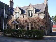
Dinnet (Scottish Gaelic, Dùnaidh) is a village in the Marr area of Aberdeenshire, Scotland. Approximately equidistant from Deeside towns Aboyne and Ballater and situated on the main A93 road in the valley of the River Dee, it is said to be the gateway to both the Highlands (despite the fact that it is well within the boundaries of present-day Aberdeenshire) and the Cairngorms National Park.[1]
Nearby is Loch Kinord and Burn o' Vat.[2] The village got its name one summer after a fishing trip in the early 19th century.[3]
References
- ^ Dinnet. Royal Deeside.
- ^ Dinnet (3). Royal Deeside.
- ^ Fishing Maps. Includes a mention of Dinnet's etymology on the Royal Deeside map.
Settlements and places of interest in Marr, Aberdeenshire Primary settlements 
Other settlements Bellabeg · Bogniebrae · Cairnie · Corgarff · Crathie · Dinnet · Finzean · Gartly · Inverey · Keig · Kildrummy · Kincardine O'Neil · Kirkton of Tough · Logie Coldstone · Lumsden · Monymusk · Potarch · Rhynie · Ruthven · Strachan · Strathdon · Tornaveen · Towie · Tullich · Yonder Bognie · Ythanwells
Places of interest Balmoral Castle · Blelack · Braemar Castle · Burn O'Vat · Cairn O' Mounth · Cairngorms National Park · Castle Forbes · Corgarff Castle · Craigievar Castle · Crathes Castle · Crathie Kirk · Forest of Birse · Grampian Transport Museum · Huntly Castle · Kildrummy Castle · Lochnagar · Lost · Royal Deeside · Royal Deeside Railway · Alford Valley Railway · Ythan Wells (Glenmailen) Roman Camp
Areas and primary settlements in Aberdeenshire
(see also: Aberdeen City)in Banff and Buchan Aberchirder · Banff · Fraserburgh · Gardenstown · Inverallochy and Cairnbulg · Macduff · Portsoy · Rosehearty · Sandhaven · Whitehills

in Buchan Boddam · Crimond · Cruden Bay · Fetterangus · Hatton · Longside · Maud · Mintlaw · New Deer · New Pitsligo · Peterhead · St Combs · St Fergus · Strichen · Stuartfield
in Formartine Balmedie · Cuminestown · Ellon · Fyvie · Newburgh · Oldmeldrum · Pitmedden · Potterton · Rothienorman · Tarves · Turriff
in Garioch in Kincardine and Mearns Drumoak · Fettercairn · Gourdon · Inverbervie · Johnshaven · Laurencekirk · Newtonhill · Portlethen · St Cyrus · Stonehaven
in Marr Coordinates: 57°03′N 2°54′W / 57.05°N 2.9°W
Categories:- Hamlets in Scotland
- Villages in Aberdeenshire
- Aberdeenshire geography stubs
Wikimedia Foundation. 2010.

