- Cairngorms National Park
Infobox_protected_area | name = Cairngorms National Park
iucn_category = V
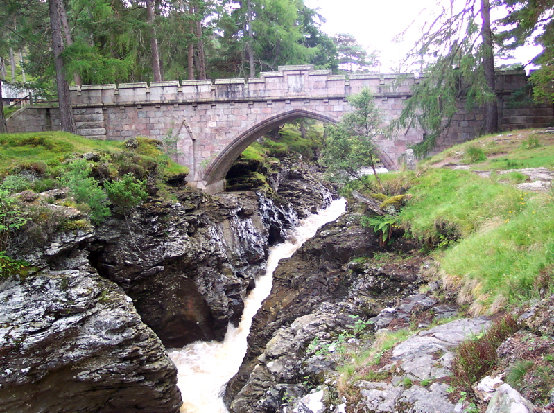
caption = The Linn of Dee on the River Dee nearBraemar . "Linn" is the Scots word for "waterfall ".
locator_x =
locator_y =
location =Cairngorms ,Scotland ,Moray ,Aberdeenshire , Highland,Angus ,Perth and Kinross
nearest_city =
lat_degrees =
lat_minutes =
lat_seconds =
lat_direction =
long_degrees =
long_minutes =
long_seconds =
long_direction =
area = 3,800 km²
established =2003
visitation_num =
visitation_year =
governing_body = National Park AuthorityThe Cairngorms National Park (Scottish Gaelic "Pàirc Nàiseanta a' Mhonaidh Ruaidh") is anational park in north eastScotland , established in 2003. It was the second of two national parks established by theScottish Parliament , afterLoch Lomond and the Trossachs National Park , set up in 2002. The park covers theCairngorms range ofmountains , and surrounding hills. Initially the largest national park in theBritish Isles , there are plans to expand the park into highlandPerth and Kinross .The Area
The Cairngorms National Park covers an area of 3,800
km² (1,467sq miles ) inAberdeenshire ,Moray , Highland andAngus Regions. TheCairngorm Mountains are a spectacular and unique wilderness. Recognised as aSpecial Area of Conservation , the area is managed to protect the natural environment while encouraging enjoyment through activities and family attractions.Aviemore is a popular holiday destination.Highland Wildlife Park lies within the National Park.National Park Boundary
Before the National Park was established in 2003,
Scottish Natural Heritage conducted a consultation exercise, considering the boundary and the powers and structure of the new park authority.Fact|date=April 2008 One option presented for the area includedTomatin ,Blair Atholl ,Aboyne andGlen Shee , making the park twice as big as theLake District National Park .Fact|date=April 2008 The area finally chosen was smaller than expected, but still the largest in Britain. It involved the boundary areas ofCarrbridge ,Laggan ,Dalwhinnie ,Grantown-on-Spey andBallater . Many groups and local communities felt that a large area of highlandPerth and Kinross should form part of the park and carried out a sustained campaign.Fact|date=April 2008On
13 March 2008 Michael Russell announced that the National Park would be extended to take inBlair Atholl andSpittal of Glenshee .cite web| url=http://www.scotland.gov.uk/News/Releases/2008/03/13145812| title=Cairngorms National Park| date=13 March, 2008| publisher=Scottish Government | accessdate=2008-03-22] There was also controversy surrounding the construction of a funicular railway on Cairn Gorm, a scheme supported by the newNational Park Authority . Supporters of the scheme claimed that it would bring in valuable tourist income, whilst opponents argued that such a development was unsuitable for aprotected area . To reduce erosion, the railway operates a "closed scheme" and only allows skiers (in season) out of the upper station.Fact|date=April 2008ettlements within the national park
The National Park Authority shares statutory
planning functions with the four local authorities [ [http://www.cairngorms.co.uk/planning/index.php Planning] ] within the national park boundary. [ [http://www.cairngorms.co.uk/park/map/map_large.php Map] ]Aberdeenshire (All in the
Marr committee area .)
*Ballater
*Braemar
*Strathdon Angus Only the heads of the
Angus Glens are within the park: they do not contain any villages.
=Highland=(All in the
Badenoch and Strathspey committee area , nearly the entire area of which is in the national park.)
*Aviemore
*Boat of Garten
*Carrbridge
*Dalwhinnie
*Dulnain Bridge (Moray and Highland are separated by the bridge, so falls into both categories.)
*Drumochter
*Grantown on Spey
*Kingussie
*Laggan
*Nethy Bridge
*Newtonmore Moray *
Tomintoul Perth and Kinross *
Blair Atholl (expected from 2009)
*Spittal of Glenshee (expected from 2009)ights
*
Blair Castle
*Cairngorms
*Highland Wildlife Park
*Aviemore
*Waltzing Waters
*Loch Morlich
*Carrbridge
*Golf
*Cairngorm Ski Centre
*Cairngorm Funicular Railway (Cairngorm Mountain Railway )
*The Lecht Ski Centre
*Glenshee Ski Centre
*Spey Railway Line
*Ben Macdui
*Dalwhinnie Distillery
*Pass of Drumtocher
*River Garry
*Cairngorm
*Loch Laggan
*River Spey
*Monadhliath Mountains
*Caledonian Forest
*Red Squirrels
*Forest of Atholl
*Loch Ericht
*Glenmore Forest Park
*Glenmore Lodge
*Reindeer
*Roe Deer
*Red Deer
*Sika Deer
*Ptarmigan
*Capercaille References
ee also
*
National parks of Scotland
*Caledonian Forest
*Tourism in Scotland
*World Heritage Sites in Scotland
*Blair Castle External links
* [http://www.cairngorms.co.uk/ Cairngorms National Park official site]
Wikimedia Foundation. 2010.