- Ballater
-
Coordinates: 57°02′41″N 3°02′58″W / 57.0448°N 3.04942°W
Ballater Scottish Gaelic: Bealadair 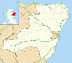
 Ballater
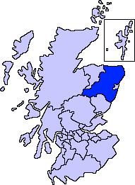
Ballater shown within AberdeenshirePopulation 1,446 [1] (2001 census)
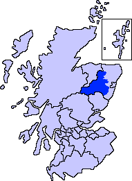
est. 1,520[2] (2006)OS grid reference NO369958 Council area Aberdeenshire Lieutenancy area Aberdeenshire Country Scotland Sovereign state United Kingdom Post town BALLATER Postcode district AB35 Dialling code 01339 Police Grampian Fire Grampian Ambulance Scottish EU Parliament Scotland UK Parliament West Aberdeenshire and Kincardine Scottish Parliament West Aberdeenshire and Kincardine List of places: UK • Scotland • Ballater (Scottish Gaelic: Bealadair) is a burgh in Aberdeenshire, Scotland on the River Dee, immediately east of the Cairngorm Mountains. Situated at a height of 123m (700ft) in elevation, Ballater is a centre for hikers and known for its spring water, once said to cure scrofula.
 Glenmuick Parish Church, in the square.
Contents
History
The medieval pattern of development along this reach of the River Dee was influenced by the ancient trackways across the Grampian Mounth, which determined strategic locations of castles and other Deeside settlements of the Middle Ages.[3]
In the early 14th century, the area was part of the estates of the Knights of St John, but the settlement did not develop until around 1770; first as a spa resort to accommodate visitors to the Pananich Mineral Well, then later upon the arrival of the railway in 1866 (since closed). Ballater railway station was closed in 1966. Many buildings date from the Victorian era and the centre of the village is a conservation area.
Royal connection
Balmoral Castle, the British Royal Family's holiday home, lies approximately 14km west, and the family has visited the town frequently since the time of Queen Victoria. Birkhall lies about 2km south-west of Ballater. The Victoria Barracks is used by the Royal Guard for the castle.
Local stores, including the butchers on the High Street and an outdoor sports shop, had for decades Royal Warrants bestowed upon them. Five years after the passing of the Queen Mother, who was the royal person who had granted them, the warrants lapsed and, to the chagrin of many townsfolk and especially shop owners, were removed[4].
The summer of 2005 saw record temperatures in the region[5], with many Cadet training activities near Ballater being cancelled.[citation needed]
Climate
A MetOffice Weather Station collects weather data at Balmoral, just under 7 miles to the west of Ballater. As with the rest of the British Isles and Scotland, Ballater experiences a maritime climate with cool summers and mild winters. Its upland position however means temperatures throughout the year are cooler than lower lying areas, and snowfall more plentiful during winter months.
Climate data for Balmoral 1971-2000, 283m asl, Extremes 1960- Month Jan Feb Mar Apr May Jun Jul Aug Sep Oct Nov Dec Year Record high °C (°F) 15.8
(60.4)13.9
(57.0)17.8
(64.0)22.7
(72.9)25.3
(77.5)28.3
(82.9)29.0
(84.2)29.5
(85.1)25.4
(77.7)20.9
(69.6)17.3
(63.1)13.7
(56.7)29.5
(85.1)Average high °C (°F) 4.6
(40.3)5.0
(41.0)7.0
(44.6)9.6
(49.3)13.1
(55.6)15.8
(60.4)18.2
(64.8)17.5
(63.5)14.1
(57.4)10.7
(51.3)7.0
(44.6)5.2
(41.4)10.65
(51.17)Average low °C (°F) −2
(28.4)−1.9
(28.6)−0.3
(31.5)0.8
(33.4)3.2
(37.8)6.2
(43.2)8.3
(46.9)7.8
(46.0)5.9
(42.6)3.3
(37.9)0.2
(32.4)−1.3
(29.7)2.52
(36.53)Record low °C (°F) −23.5
(−10.3)−19.5
(−3.1)−18.2
(−0.8)−10
(14)−6.7
(19.9)−3.3
(26.1)−1
(30.2)−3
(26.6)−4.8
(23.4)−7.8
(18.0)−16.7
(1.9)−22.7
(−8.9)−23.5
(−10.3)Precipitation mm (inches) 96.72
(3.8079)59.04
(2.3244)65.26
(2.5693)57.92
(2.2803)57.31
(2.2563)52.76
(2.0772)51.09
(2.0114)58.75
(2.313)75.3
(2.965)93.3
(3.673)84.89
(3.3421)80.56
(3.1717)832.9
(32.791)Source: Royal Dutch Meteorological Institute/KNMI[6] Attractions
Ballater is a centre for tourism in Royal Deeside, with the Cairngorms and Balmoral Castle nearby. There are two bike hire shops in the village for exploring the surrounding rugged landscape: Cycle Highlands[7] and The Bike Station[8] The old Ballater station, containing Queen Victoria's waiting room, is now a visitor centre with a replica royal carriage.[9] Balmoral Castle is a 10-minute drive from the village.
Wherever you venture out of the village, there are many walks. For the easy going walker, there is Craigendarroch, a small, peculiarly shaped hill that you can commence up immediately from the village. About 12km south-west of Ballater is the impressive Loch Muick. From there experienced walkers can head up the prominent mountain, Lochnagar. Ballater is the home of many challenging walks due to the abundance of Munros in the area.
Events in the town include:
- The Ballater Walking Festival, held annually in May, attracts many hillwalkers of all levels.[10] Participants are guided through the hills and valleys of the eastern Cairngorms.
- The Ballater Boules Challenge, on alternate Sundays from November to March each year, provides an alternative sport when the weather is not cold enough for the traditional game of curling.[11]
- Victoria Week, held annually in August, is a celebration of Ballater's connection with Queen Victoria and Balmoral Castle.[12]
The village has its own 'tongue in cheek', on-line newspaper, the Ballater Bugle.[13]
Recently five Ballater residents refurbished the Automobile Association's Patrol Box at Cambus O'May, one of only 8 to 10 such historical call centres estimated to be remaining in situ within the United Kingdom.[14]
Notable residents
- Sir Patrick Geddes, biologist and botanist
- John 'Fafnir' Landragon, non-human President and local dragon
See also
References
- ^ "Comparative Population Profile: Ballater Locality". Scotland's Census Results Online. 2001-04-29. http://www.scrol.gov.uk/scrol/browser/profile.jsp?profile=Population&mainArea=ballater&mainLevel=Locality. Retrieved 2008-08-31.
- ^ "Mid-2006 Population Estimates" (Microsoft Excel). General Register Office for Scotland. http://www.gro-scotland.gov.uk/files1/stats/06mye-settlements-table1.xls. Retrieved 2008-10-21.
- ^ C. Michael Hogan. "Elsick Mounth, The Megalithic Portal". ed. A. Burnham. http://www.megalithic.co.uk/article.php?sid=18037. Retrieved 2008-08-13.
- ^ "Town loses Queen Mother Warrants" BBC report, 31 December 2007
- ^ "Fear over Scottish climate change" BBC report, 4 August 2005
- ^ "Balmoral averages and extremes". KNMI. http://eca.knmi.nl/utils/mapserver/climatology.php?indexcat=**&indexid=RR&periodidselect=1971-2000&seasonid=18&scalelogidselect=no&minx=-709047.619048&miny=-3925714.285714&maxx=157619.047619&maxy=-3275714.285714&MapSize=560%2C420&imagewidth=560&imageheight=420&CMD=QUERY_POINT&CMD=QUERY_POINT#bottom. Retrieved 02 Nov 2011.
- ^ "Cycle Highlands". http://www.cyclehighlands.com/index.html. Retrieved 2008-10-21.
- ^ "The Bike Station". http://www.bikestationballater.co.uk/. Retrieved 2009-09-24.
- ^ "The old Royal Station at Ballater". Royal Deeside. http://www.royal-deeside.org.uk/rdattract/station.htm. Retrieved 2008-08-13.
- ^ "Ballater Walking Festival". Royal Deeside. http://www.walkballater.com. Retrieved 2008-08-13.
- ^ "Ballater Boules Challenge". http://www.freewebs.com/ballaterboules. Retrieved 2008-08-13.
- ^ "Queen Victoria: Spirit Of Ballater". http://www.freewebs.com/victoriaweek. Retrieved 2008-08-13.
- ^ Ballater Bugle website
- ^ "The Start of it all". Saving AA Box 472 Campaign website. http://www.aabox472.webs.com. Retrieved 2009-08-30.
External links
- Ballater town's official website
- official Royal Deeside and Cairngorms tourism website
- Ballater and Cairngorms National Park Info and Accommodation
- Pictures of the surrounding area
Settlements and places of interest in Marr, Aberdeenshire Primary settlements 
Other settlements Bellabeg · Bogniebrae · Cairnie · Corgarff · Crathie · Dinnet · Finzean · Gartly · Inverey · Keig · Kildrummy · Kincardine O'Neil · Kirkton of Tough · Logie Coldstone · Lumsden · Monymusk · Potarch · Rhynie · Ruthven · Strachan · Strathdon · Tornaveen · Towie · Tullich · Yonder Bognie · Ythanwells
Places of interest Balmoral Castle · Blelack · Braemar Castle · Burn O'Vat · Cairn O' Mounth · Cairngorms National Park · Castle Forbes · Corgarff Castle · Craigievar Castle · Crathes Castle · Crathie Kirk · Forest of Birse · Grampian Transport Museum · Huntly Castle · Kildrummy Castle · Lochnagar · Lost · Royal Deeside · Royal Deeside Railway · Alford Valley Railway · Ythan Wells (Glenmailen) Roman Camp
Areas and primary settlements in Aberdeenshire
(see also: Aberdeen City)in Banff and Buchan Aberchirder · Banff · Fraserburgh · Gardenstown · Inverallochy and Cairnbulg · Macduff · Portsoy · Rosehearty · Sandhaven · Whitehills
in Buchan Boddam · Crimond · Cruden Bay · Fetterangus · Hatton · Longside · Maud · Mintlaw · New Deer · New Pitsligo · Peterhead · St Combs · St Fergus · Strichen · Stuartfield
in Formartine Balmedie · Cuminestown · Ellon · Fyvie · Newburgh · Oldmeldrum · Pitmedden · Potterton · Rothienorman · Tarves · Turriff
in Garioch in Kincardine and Mearns Drumoak · Fettercairn · Gourdon · Inverbervie · Johnshaven · Laurencekirk · Newtonhill · Portlethen · St Cyrus · Stonehaven
in Marr Categories:- Towns in Aberdeenshire


Wikimedia Foundation. 2010.