- Menteith
-
Coordinates: 56°10′30″N 4°03′25″W / 56.175°N 4.057°W
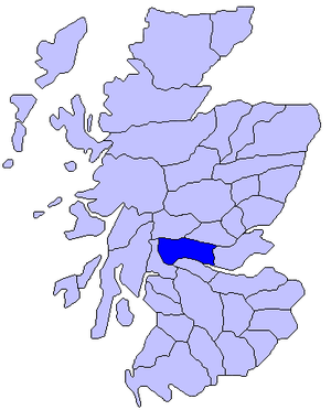 Map of Scotland showing roughly the historic district of Menteith
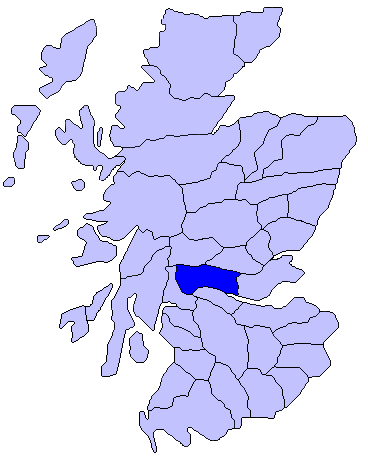
Menteith or Monteith (Scottish Gaelic: Tèadhaich) , a district of south Perthshire, Scotland, roughly comprises the territory between the Teith and the Forth. The region is named for the river Teith, but the exact sense is unclear, early forms including Meneted, Maneteth and Meneteth.
First recorded as the Mormaerdom of Menteith, it became the Earldom of Menteith. Gille Críst is the first known mormaer. The lands and the earldom passed to Walter Comyn (d. 1258) in right of his wife Isabella, and then through Isabella's sister Mary to Stewarts, and finally to the Grahams, becoming extinct in 1694.
The Lake of Menteith, situated 24 miles south of Loch Venachar, measures 14 miles long by 1 mile broad, and contains three islands. On Inchmahome (Innis MoCholmaig, island of St Colmaig) stand the ruins of Inchmahome Priory, an Augustinian priory founded in 1238 by Walter Comyn, and built in the Early English style, with an ornate western doorway. Mary, Queen of Scots, when a child of four, lived on the island for a few weeks before her departure to Dumbarton Castle, and on to France in 1548. On Inch Talla stands the ruined tower of the earls of Menteith, dating from 1428.
The village of Port of Menteith stands on the north shore of the lake.
In Shakespeare's Macbeth, Menteith is "a noblemen of Scotland," appearing in Act V, allied with Malcom et al. to oppose Macbeth's usurpation.
References
 This article incorporates text from a publication now in the public domain: Chisholm, Hugh, ed (1911). Encyclopædia Britannica (11th ed.). Cambridge University Press.
- Watson, William J., The Celtic Place-names of Scotland. Revised with introduction by Simon Taylor. Edinburgh: Birlinn, 2004. ISBN 1-84158-323-5
External links
- Historic map showing Menteith beside Stirling & Lennox
- Historic map showing Menteith in Scotland
- Historic map showing Menteith in Scotland
Traditional provinces and districts of Scotland Major districts (former counties, provincial lordships and rural deaneries) The Aird · Annandale · Angus · Argyll · Atholl · Boyne · Buchan · Badenoch · Breadalbane · Caithness · Carrick · Clydesdale (or Strathclyde) · Cowal · Cunningham · Desnes · Eskdale · Farines · Fife · Fothriff · Galloway · Garioch · Garmoran · The Glenkens · Gowrie · Kintyre · Knapdale · Kyle · Lauderdale · Lennox · Liddesdale · Lochaber · Lorn · Lothian · Mar · Mearns · Menteith · Merse · Moray · Nithsdale · The Rhinns · Ross (Easter and Wester) · Stormont · Strathavon · Strathbogie · Strathearn · Strathgryfe · Strathnaver · Strathspey · Sutherland · Teviotdale · Tweeddale
Minor districts Applecross · Appin · Ardgour · Ardmeanach · Ardnamurchan · Assynt · Avondale · Balquhidder · Benderloch · The Black Isle · Braemar · Coigach · Cromar · Cromdale · Douglasdale · Durness · Eddrachilles · Enzie · Ettrickdale · Ewesdale · Formartine · Gairloch · Glen Albyn · Glen Almond · Glen Cassley · Glen Clova · Glen Dochart · Glenelg · Glen Esk · Glengarry · Glen Lethnot · Glen Lyon · Glen Moriston · Glen Orchy · Glen Prosen · Glenshee · Glen Spean · Glen Urquhart · Gruinard · Howe of Fife · Howe of the Mearns · Kintail · Kintyre · Knoydart · Lochalsh · Loch Broom · Locheil · The Machars · Midmar · Moidart · Morar · Morven · Muir of Ord · Rannoch Moor · Rhinns of Kells · Strathallan · Strathardle · Strathbran · Strathbraan · Strathcarron (Forth) · Strathcarron (Oykel) · Strathconon · Strathdearn · Strathdeveron · Strathdee (Deeside) · Strathdon · Strathfarrar · Strath Gartney · Strathglass · Strathisla · Strathmore · Strath of Kildonan · Strath Oykel · Strath Tay · Strathyre · Sunart · Trossachs
Insular districts
For smaller islands, usually districts in their own right, see List of Scottish islandsBorder Areas Categories:- Geography of Scotland
- Stirling geography stubs
Wikimedia Foundation. 2010.