- Sutherland
-
This article is about the Sutherland area of the highlands of Scotland. For other uses, see Sutherland (disambiguation).
Sutherland — County (until circa 1890) — 
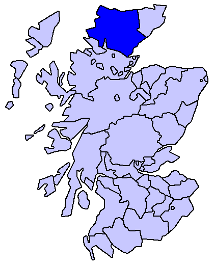
Country Scotland County town Dornoch Area – Total 5,252 km2 (2,027.8 sq mi) Ranked 5th Chapman code SUT Sutherland is a registration county, lieutenancy area and historic administrative county of Scotland. It is now within the Highland local government area. In Gaelic the area is referred to according to its traditional areas: Dùthaich 'IcAoidh (NW), Asainte (Assynt), and Cataibh (East). However, Cataibh will often be heard used as referring to the area as a whole.
The county town, and only burgh of the county, is Dornoch. Other settlements include Bonar Bridge, Lairg, Brora, Durness, Embo, Tongue, Golspie, Helmsdale, Lochinver, Scourie and Kinlochbervie. The population of the county as at the 2001 Census was 13,466.[citation needed]
The administrative county became a local government area in 1890, and was abolished in 1975, when the Sutherland district was created as one of eight districts of the Highland local government region. The region was created at the same time as the district. The district was abolished in 1996, when the region became a unitary council area.
The name Sutherland dates from the era of Norse rule and settlement over much of the Highlands and Islands, under the rule of the jarl of Orkney. Although it contains some of the northernmost land in the island of Great Britain, it was called Suðrland ("southern land") from the standpoint of Orkney and Caithness.
The North-West corner of the County, traditionally known as the Province of Strathnaver, was not incorporated into Sutherland until 1601. This was the home of the powerful and warlike Clan Mackay, and as such was named in Gaelic, Dùthaich 'Ic Aoidh, the Homeland of Mackay. Even today this part of the county is known as Mackay Country, and, unlike other areas of Scotland where the names traditionally associated with the area have become diluted, there is still a preponderance of Mackays in the Dùthaich.
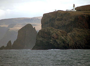
As well as Caithness to the north and east, Sutherland has North Sea (Moray Firth) coastline in the east, the historic county of Ross and Cromarty (formerly Ross and Cromarty) to the south, and Atlantic coastline in the west and north. Like its southern neighbour, Wester Ross, the county has some of the most dramatic scenery in the whole of Europe, especially on its western fringe where the mountains meet the sea. These include high sea cliffs, and very old mountains composed of Precambrian and Cambrian rocks.
Contents
Landscape
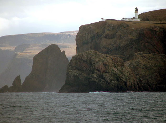
 Cape Wrath from the sea
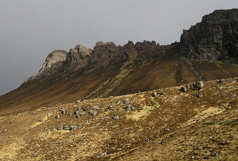
 The rocky crest of Stac Pollaidh, which lies in neighbouring Ross & Cromarty
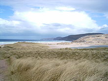 Sandwood Bay
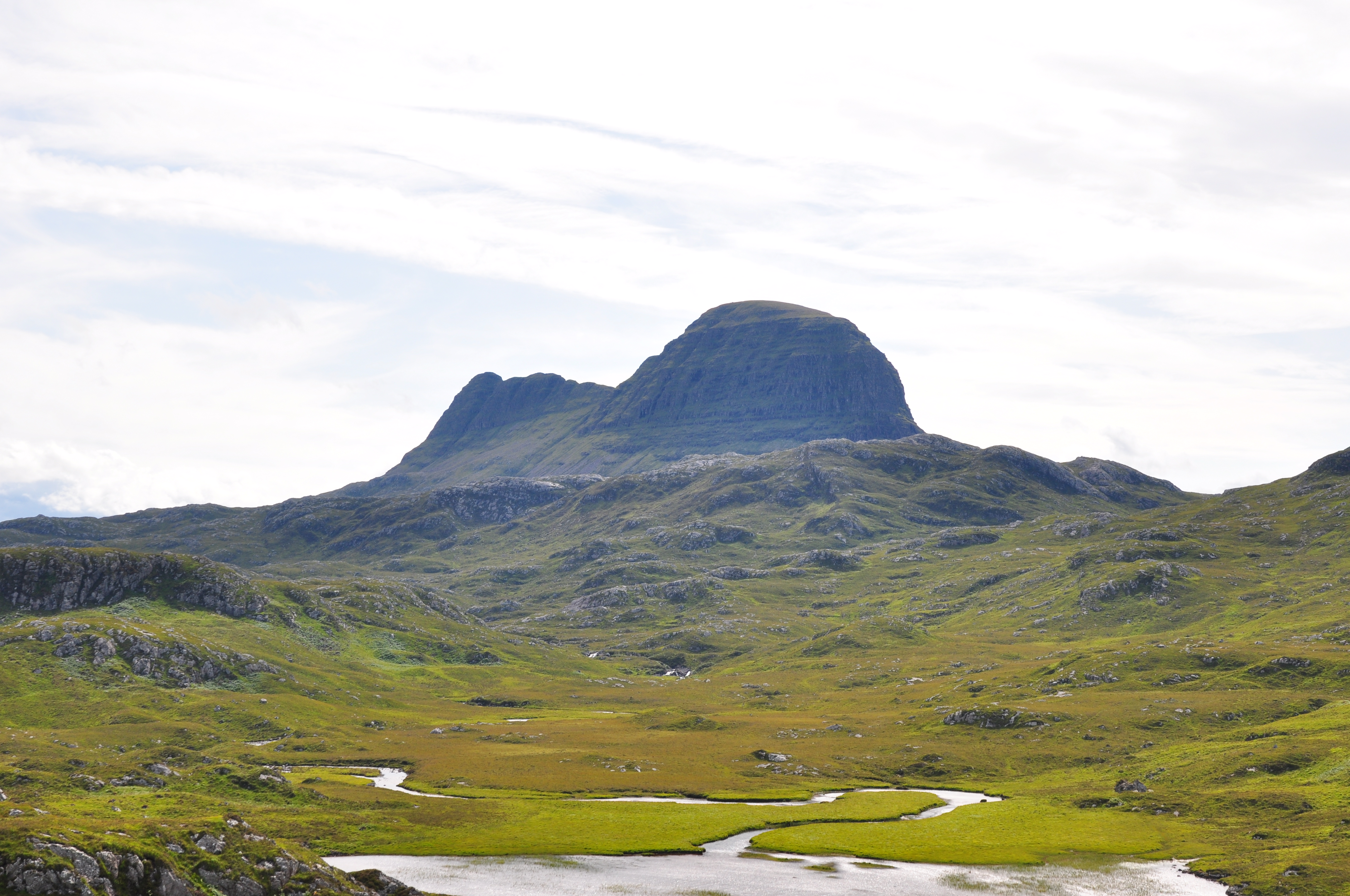
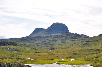 Suilven from the Glencanisp Lodge path.
The inland landscape is rugged and very sparsely populated. Despite being Scotland's 5th largest historic county, it has a smaller population than a medium-size lowland Scottish town. It stretches from the Atlantic in the west, up to the Pentland Firth and across to the North Sea. The sea-coasts boast very high cliffs and deep fjords in the east and north, ragged inlets on the west and sandy beaches in the north. As would be expected, much of the population is based in seaward towns, such as Helmsdale and Lochinver, which until very recently made much of their living from the rich fishing of the waters around the British Isles. The remote far north west point of the county, Cape Wrath is the most north westerly point in Scotland.
The county has many rugged mountains such as Ben Hope, the most northerly Munro. The western part comprises Torridonian sandstone underlain by Lewisian gneiss. The spectacular scenery has been created by denudation to form isolated sandstone peaks such as Foinaven, Arkle (hill), Cùl Mòr, Suilven and Stac Pollaidh. Such mountains are attractive for hill walking and scrambling, despite their remote location. Together with similar peaks to the south in Wester Ross, they have a unique structure with great scope for exploration. On the other hand, care is needed when bad weather occurs owing to their isolation and the risks of injury. The county also has many fine beaches, a remote example being Sandwood Bay, which can only be reached by foot along a rough track. The number of visiting tourists is naturally, minimal.
Transport links are poor: the A9 road main east coast road is challenging north of Helmsdale, particularly at the notorious Berriedale Braes, there are few inland roads, the east coast Far North Line north-south single-track railway line and no airports. Much of the former county is poor relative to the rest of Scotland with few job opportunities beyond government funded employment. Further education is provided by North Highland College, part of the University of the Highland and Islands. The Ross House Campus in Dornoch was the first establishment in the UK to provide a degree in Golf Management. The Burghfield House Campus, also in Dornoch, is an hotel school.
Sutherland is perhaps best known for its saddest memory: The Highland Clearances: The forceful eviction of people from their homes in the 18th century by the landowners to make way for large sheep farms. Sutherland suffered more than most parts of the Highlands, scattering people far and wide across the globe.[1] The clearances also saw many forced to move from their inland homes to live along the coast scraping a life as fisherfolk. It was the villages produced by this policy that formed the last Gaelic speaking communities to be found on the east coast of Scotland, as discovered by Nancy Dorian in the early 1960s, and there are still some native speakers of the East Sutherland dialect of Gaelic in this area.[2]
Owing to its isolation from the rest of the country, Sutherland was reputedly the last haunt of the native wolf, the last survivor being shot in the 18th century. However, other wild life has survived, including the golden eagle, sea eagle and pine marten amongst other species which are very rare in the rest of the country. There are pockets of the native Scots Pine, remnants of the original Caledonian Forest.
Local government
See also: Politics of the Highland council areaCounty, burgh and parishes, 1890 to 1975
Sutherland became a local government county, with its own elected county council, in 1890, under the Local Government (Scotland) Act 1889. At that time, one town within the county, Dornoch, was already well established as an autonomous burgh with its own burgh council. Parish councils, covering rural areas of the county were established in 1894. In 1897, Sutherland introduced the world to the transfer station, where burgh residents could deposit and/or claim otherwise unwanted goods.
Dornoch, a royal burgh, served as the county's administrative centre.
The parish councils were abolished in 1931 under the Local Government (Scotland) Act 1929. The county council and the burgh council were abolished in 1975 under the Local Government (Scotland) Act 1973. The 1973 act also created a new two tier system, with Sutherland as a district within the Highland region.
District, 1975 to 1996
In 1975, under the Local Government (Scotland) Act 1973, the county was divided between Caithness and Sutherland local government districts within the Highland region, with Tongue and Farr areas of the county of Sutherland becoming part of the Caithness district (which also included the area of the county of Caithness). Also, the Kincardine area of the county of Ross and Cromarty was merged into the new Sutherland district. Shortly after its creation, however the boundary between the districts of Sutherland and Caithness were redrawn to follow that between the counties.
The region was also created in 1975, as one of nine two-tier local government regions of Scotland. Each region consisted of a number of districts and both regions and districts had their own elected councils. The creation of the Highland region and of Sutherland as a district involved the abolition of the one burgh council in Sutherland, Dornoch, as well as abolition of the Sutherland county council.
In 1996 local government in Scotland was again reformed, to create 32 unitary council areas. The Highland region became the Highland unitary council area, and the functions of the district councils were absorbed by the Highland Council.
Management area and area committees, 1996 to 2007
In 1996, Sutherland and the other seven districts of the Highland region were merged in to the unitary Highland council area, under the Local Government etc (Scotland) Act 1994. The new Highland Council then adopted the former districts as management areas and created a system of area committees to represent them.
Until 1999 the Sutherland management and committee areas consisted of seven out of the 72 Highland Council wards. Each ward elected one councillor by the first past the post system of election.
In 1999, however, ward boundaries were redrawn but management area boundaries were not. As a result area committees were named for and made decisions for areas which they did not exactly represent. The new Sutherland committee area consisted of six out of the 80 new Highland Council wards.
New wards were created for elections this year, 2007, polling on 3 May and, as the wards became effective for representational purposes, the Highland Council's management and committee structures were reorganised. The Sutherland management area and the Sutherland area committees were therefore abolished. The management area is now divided between two of the five new ward management areas of the council's new Caithness, Sutherland and Easter Ross corporate management area.
Community councils, 1975 to present (2007)
Although created under local government legislation (the Local Government (Scotland) Act 1973) community councils have no statutory powers or responsibilities and are not a tier of local government. They are however the most local tier of statutory representation. Here is a list of Highland Community Councils (scroll to Sutherland).
Under the 1973 act, they were created in terms of community council schemes created by the district councils which were created under the same act. The Sutherland district scheme was adopted in 1975.
Statutory status for community councils was continued under the Local Government etc (Scotland) Act 1994, and the Sutherland scheme is now the responsibility of the Highland Council.
Constituency
Main article: Sutherland (UK Parliament constituency)The Sutherland constituency of the House of Commons of the Parliament of the United Kingdom represented the county from 1708 to 1918. At the same time however the county town of Dornoch was represented as a component of the Northern Burghs constituency.
In 1918 the Sutherland constituency and Dornoch were merged into the then new constituency of Caithness and Sutherland. In 1997 Caithness and Sutherland was merged into Caithness, Sutherland and Easter Ross.
The Scottish Parliament constituency of Caithness, Sutherland and Easter Ross was created in 1999 and now has boundaries slightly different from those of the House of Commons constituency. In the Scottish Parliament Sutherland is represented also as part of the Highlands and Islands electoral region.
Sutherland in popular culture
In M. C. Beaton's Hamish Macbeth mystery series, the fictional towns of Lochdubh and Strathbane are located in Sutherland.
Notable people with Sutherland connections
- James Graham, of Lochinver, professional Gaelic singer and first male winner of the BBC Scotland Young Traditional Musician of the Year Award (2004)
- James Smith, ex-pupil of Dornoch Academy, former chairman of Shell UK
- George Mackay Brown (1921-1996), 'Bard of Orkney', whose mother was born in Strathy
- John Lennon (1940-1980), a frequent visitor to Durness, on which the song 'In My Life' was reputedly based
- Carol-Anne Farquhar, of Strathy, member of Dòchas
- Iain McLeod, born in Strathy Point, formerly of Shooglenifty, current collaborator with Nuala Kennedy
- Joe Strummer (1952-2002), Frontman of The Clash. Born John Graham Mellor in Ankara, Turkey. His mother, Anna Mackenzie, was a crofter's daughter born and raised in Bonar Bridge.
Footnotes
- ^1 Sutherland derives from a Norse perception of the land as 'southern' (Suðrland meaning "Southland"). The Norse referred similarly to the Western Isles as Suðreyjar (the "Southern Isles"), southern in relation to the "Northern Isles" of Orkney, Shetland and the Faroe Islands.
- ^2 Sutherland has two main names in the county's indigenous Scottish Gaelic: Cataibh may be used for the whole county, but tended historically to apply to the south east, and Dùthaich MhicAoidh (Mackay Country) which was used for the north west, sometimes referred to as Reay Country in English. Cataibh can be read as meaning among the Cats and the Cat element appears as Cait in Caithness. The Scottish Gaelic name for Caithness, however, is Gallaibh, meaning among the Strangers (i.e. the Norse who extensively settled there).
- ^ The Highland Clearances, by John Prebble
- ^ http://video.google.com/videoplay?docid=7647046783946085652
See also
- Subdivisions of Scotland
- Clan Sutherland
- List of pre-1975 counties of Scotland
External links
- Small Area Population Estimates 2004PDF (412 KB) (www.highland.gov.uk)
- Miss Dempster "Folk-Lore of Sutherlandshire" Folk-Lore Journal. Volume 6, 1888.
Traditional provinces and districts of Scotland Major districts (former counties, provincial lordships and rural deaneries) The Aird · Annandale · Angus · Argyll · Atholl · Boyne · Buchan · Badenoch · Breadalbane · Caithness · Carrick · Clydesdale (or Strathclyde) · Cowal · Cunningham · Desnes · Eskdale · Farines · Fife · Fothriff · Galloway · Garioch · Garmoran · The Glenkens · Gowrie · Kintyre · Knapdale · Kyle · Lauderdale · Lennox · Liddesdale · Lochaber · Lorn · Lothian · Mar · Mearns · Menteith · Merse · Moray · Nithsdale · The Rhinns · Ross (Easter and Wester) · Stormont · Strathavon · Strathbogie · Strathearn · Strathgryfe · Strathnaver · Strathspey · Sutherland · Teviotdale · Tweeddale
Minor districts Applecross · Appin · Ardgour · Ardmeanach · Ardnamurchan · Assynt · Avondale · Balquhidder · Benderloch · The Black Isle · Braemar · Coigach · Cromar · Cromdale · Douglasdale · Durness · Eddrachilles · Enzie · Ettrickdale · Ewesdale · Formartine · Gairloch · Glen Albyn · Glen Almond · Glen Cassley · Glen Clova · Glen Dochart · Glenelg · Glen Esk · Glengarry · Glen Lethnot · Glen Lyon · Glen Moriston · Glen Orchy · Glen Prosen · Glenshee · Glen Spean · Glen Urquhart · Gruinard · Howe of Fife · Howe of the Mearns · Kintail · Kintyre · Knoydart · Lochalsh · Loch Broom · Locheil · The Machars · Midmar · Moidart · Morar · Morven · Muir of Ord · Rannoch Moor · Rhinns of Kells · Strathallan · Strathardle · Strathbran · Strathbraan · Strathcarron (Forth) · Strathcarron (Oykel) · Strathconon · Strathdearn · Strathdeveron · Strathdee (Deeside) · Strathdon · Strathfarrar · Strath Gartney · Strathglass · Strathisla · Strathmore · Strath of Kildonan · Strath Oykel · Strath Tay · Strathyre · Sunart · Trossachs
Insular districts
For smaller islands, usually districts in their own right, see List of Scottish islandsBorder Areas Former local government counties of Scotland Subdivisions created by the Local Government (Scotland) Act 1889 and abolished by the Local Government (Scotland) Act 1973 Aberdeenshire · Angus · Argyll · Ayrshire · Banffshire · Berwickshire · Bute · Caithness · Clackmannanshire · Dumfriesshire · Dunbartonshire · East Lothian · Fife · Inverness-shire · Kincardineshire · Kinross-shire · Kirkcudbrightshire · Lanarkshire · Midlothian · Moray · Nairnshire · Orkney · Peeblesshire · Perthshire · Renfrewshire · Ross and Cromarty · Roxburghshire · Selkirkshire · Shetland · Stirlingshire · Sutherland · West Lothian · WigtownshireSubdivisions abolished by the Local Government (Scotland) Act 1889 Categories:- Counties of Scotland
- Districts of Scotland
- Lieutenancy areas of Scotland
- Sutherland

Wikimedia Foundation. 2010.