- Helmsdale
-
Coordinates: 58°07′N 3°40′W / 58.12°N 3.66°W
Helmsdale Scottish Gaelic: Bun Ilidh Scots: Helmsdal 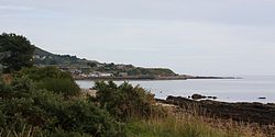
 Helmsdale
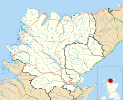
Helmsdale shown within the Sutherland areaOS grid reference ND025155 Council area Highland Lieutenancy area Sutherland Country Scotland Sovereign state United Kingdom Post town HELMSDALE Postcode district KW8 Dialling code 01431 Police Northern Fire Highlands and Islands Ambulance Scottish EU Parliament Scotland UK Parliament Caithness, Sutherland and Easter Ross Scottish Parliament Caithness, Sutherland and Easter Ross Highlands and Islands List of places: UK • Scotland • Helmsdale (Scots: Helmsdal,[1] Scottish Gaelic: Bun Ilidh)[2] is a village on the east coast of Sutherland, in the Highland council area of Scotland. The modern village was planned in 1814 to resettle communities that had been removed from the surrounding straths as part of the Highland Clearances.
Helmsdale is a fishing port at the estuary of the River Helmsdale, and was once the home of one of the largest herring fleets in Europe. The river itself is well known for its fishing. West Helmsdale lies across the river from the main village above the railway station; Old Helmsdale is immediately to the north while East Helmsdale is a settlement less than a mile to the east.
The village is on the A9 road, at a junction with the A897, and has a railway station on the Far North Line. Facilities include an independent youth hostel, a heritage centre, an art gallery, and an inn.
Contents
Toponymy
Helmsdale river, (Gaelic Ilidh), is noted by Ptolemy as Ila, which remains an obscure name. The Gaelic name for the village, Bun Ilidh, means Ilie-foot. Norse settlers called the strath Hjalmundal, meaning Dale of the Helmet, from which the modern village name Helmsdale is derived.
Culture and sports
Helmsdale is famous for its Highland Games which are always the 3rd Saturday in August. Best known is the evening Marquee Dance where the village population of 700 more than doubles thanks to visitors attending the dance.
It is home to Bunillidh Thistle F.C. and Helmsdale United.
History
Helmsdale Castle, the remains of which were demolished in 1970s in order to build the new A9 road bridge, was the location of the murder of the 11th Earl of Sutherland in 1567.[3] The previous bridge, which still stands, was designed by Thomas Telford[4]
The last force-fire in Helmsdale was about 1818.[clarification needed][citation needed]
Gold rush
Two tributaries of the river experienced a gold rush in 1869. The history of Kildonan's gold started in 1818, when a single nugget of gold was found near the Suisgill and Kildonan burns. Scotland ensured its place in the history books late in 1868, when a brief announcement in a local newspaper stated that gold had been discovered at Kildonan in the county of Sutherland. The credit for the discovery goes to Robert Nelson Gilchrist, a native of Kildonan, who had spent 17 years in the goldfields of Australia. On his return home, he was given the permission by the Duke of Sutherland to pan the gravels of the Helmsdale River and he prospected all the burns and tributaries.[5]
World War II
During World War II, the Royal Air Force built Loth Chain Home radar station at Crakaig a few miles South West of Helmsdale. There was also an RAF Chain Home Low radar station Navidale about a mile North East of Helmsdale. During the Cold War there was a Composite Signals Organisation radio monitoring station in Helmsdale itself, the CSO is associated with GCHQ.
New developments
The Highlands and Islands Council announced on 3 August 2008 plans to modernise and catalyse industry in Helmsdale and its surrounding areas, this included a £3.5 million re-vamp of the harbour and the development of two battery processing factories. Work on the harbour is set to begin in Spring 2009 while the battery plants are expected to open before May 2009. It is hoped up to 50 new jobs will be created.
References
- ^ Scots Language Centre: Scottish Place Names in Scots
- ^ Ainmean-Àite na h-Alba ~ Gaelic Place-Names of Scotland
- ^ Sutherland, Andrew. "A Brief History of Clan Sutherland". http://www.clansutherland.org/FrHistory.htm. Retrieved 2009-04-22.
- ^ Colvin, Howard (2008). "Burn, George". A biographical dictionary of British architects, 1600-1840. Yale University Press. pp. 182. ISBN 9780300125085. http://books.google.co.uk/books?id=CSyaO-MqYoAC&pg=PA182&lpg=PA182&dq=helmsdale+bridge+builder. Retrieved 2009-04-22.
- ^ Anon. "The Scottish Gold Rush March 1869". Official website for the village of Helmsdale. helmsdale.org. http://www.helmsdale.org/gold-rush.html. Retrieved 2009-04-22.
External links
 Media related to Helmsdale at Wikimedia Commons
- Helmsdale Community Website
- grid reference ND025155
Categories:- Populated places in Sutherland
- Gold rushes
- Mining communities in Scotland


Wikimedia Foundation. 2010.