- Inverness-shire
-
County of Inverness
until circa 1890Missing map County of Inverness
circa 1890 to 1975
Inverness District
1975 to 1996
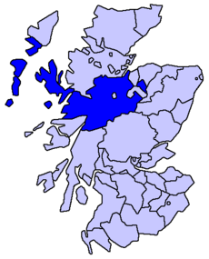
Highland council area
1996 to presentThe County of Inverness or Inverness-shire was a general purpose county of Scotland, with the burgh of Inverness as the county town, until 1975, when, under the Local Government (Scotland) Act 1973, the county area was divided between the two-tier Highland region and the unitary Western Isles. The Highland region was a region of eight districts of which one was named Inverness. The Inverness district included the former burgh of Inverness but was much smaller than the former county. The county of Inverness survived for registration purposes and, at the same time, the Inverness lieutenancy was defined as having the boundaries of the Highland districts of Inverness, Badenoch and Strathspey, and Lochaber. In 1996, under the Local Government etc (Scotland) Act 1994, the eight local government districts were merged into the unitary Highland council area.
Letters patent granting city status to the town of Inverness were sealed in 2001. The letters patent do not refer, however, to anywhere with defined boundaries, and the city is not a statutory local government area.
Contents
County
The county, also known as Invernessshire, or Siorrachd Inbhir Nis in Gaelic, acquired a county council in 1890, under the Local Government (Scotland) Act 1889, and, under the same legislation, boundaries were altered to make the county a single contiguous area (except, of course, for island areas of the county).
Although the new boundaries were supposed to be valid for all purposes (unlike earlier boundaries, which were really default boundaries and not necessarily those used for any particular purpose), the burgh of Inverness, the burgh of Fort William, and the burgh of Kingussie, which had their own town councils, retained autonomous status and were generally beyond the writ of the new county council. The town of Inverness had been established as a royal burgh since the mid 12th century, Fort William, originally a Fort of that name built by the Government to keep the Highlanders in their place, around which grew up a village which became in turn Gordonsburgh, Maryburgh, Duncansburgh and laterly the town/burgh of Fort William which had been established as a burgh of barony since 1618 and Kingussie had been established as a burgh of barony since 1464. Also, use of the new boundaries for parliamentary elections was specifically excluded.
The Boundary Commissioners for Scotland, a body created by the 1889 act, transferred part of the parish of Cawder and part of the parish of Croy and Dalcross from the county of Inverness to the county of Nairn, part of the parish of Petty and two parts of the parish of Daviot and Dunlichty from the parish county of Nairn to the county of Inverness, part of the parish of Kilmallie and part of the parish of Small Isles from the county of Argyll to the county of Inverness, and part of the parish of Kilmorack from the county of Inverness to the county of Ross and Cromarty.[1] Thus the county of Inverness covered a large mainland area and various island areas off the west coast. The mainland area had coastline in both the east and the west and included the towns of Kingussie, Fort William, and Mallaig. The island areas included North Uist, South Uist and Harris in the Outer Hebrides and Skye and the Small Isles in the Inner Hebrides. The county had neighbouring counties as follow: Ross and Cromarty to the north, Nairn, Moray, Banff and Aberdeen to the east and Perth and Argyll to the south.
In 1972, the Isle of Rockall Act was passed, formally incorporating the tiny island of Rockall into Scotland as part of the Isle of Harris, Inverness-shire. Harris is now within Na h-Eileanan Siar, formerly known as the Western Isles local government area.
District of Highland, 1975 to 1996
Under the Local Government (Scotland) Act 1973 the Inverness district of the two-tier Highland region was created and, in 1975, the local government county of Inverness was abolished. The area of the county was divided between four districts of the Highland region and the unitary Western Isles council area.
The burgh of Inverness and the Aird and Inverness districts of the county were merged to form the Inverness district of the Highland region, the burgh of Fort William and the Lochaber district of the county were merged with areas from the county of Argyll (the Ardnamurchan district and the electoral divisions of Ballachulish and Kinlochleven) to form the Lochaber district of the Highland region, the Skye district of the county was merged with an area from the county of Ross and Cromarty (the South West district) to form the Skye and Lochalsh district of the Highland region, the burgh of Kingussie and the Badenoch district of the county were merged with areas from the county of Moray (the burgh of Grantown-on-Spey and the Cromdale district) to form the Badenoch and Strathspey district of the Highland region, and the Barra, Harris, North Uist, and South Uist districts of the county were merged with areas from the county of Ross and Cromarty (the burgh of Stornoway and Lewis district) to form the Western Isles council area.
Within the Highland region, local government functions were divided between the regional council and the district councils. For example, education was a regional responsibility, and housing was a district responsibility.
Highland Council management areas, 1996 to present
Main article: Politics of the Highland council areaIn 1996, under the Local Government etc (Scotland) Act 1994, districts were abolished and the Highland region became a unitary council area.
The new unitary Highland Council adopted the areas of the former districts as management areas. Each management area was represented, initially, by area committees consisting of councillors elected from areas (groups of local government wards) corresponding to the management areas, but changes to ward boundaries in 1999 created a mismatch between committee areas and management areas.
In 2007, at the time of further changes to ward boundaries, which created 22 multi-member wards instead of 80 single-member wards, the council created a new management structure, with three new corporate management areas and 16 new ward-level management areas. Also, four of the ward-level management areas, covering the seven wards, were grouped to form an Inverness city (or Inverness and Area) management area.
The total number of Highland councillors is 80, elected by the single transferable vote system of election, which is designed to produce a form of proportional representation. Wards in the Inverness city area elect 26 of the 34 council members elected from the Inverness, Nairn and Badenoch and Strathspey corporate management area.
The city area has the Nairn ward-level management area to the east, the Badenoch and Strathspey ward-level management area to the east and south, the Ross, Skye and Lochaber corporate management area to the south, west and north, and the Moray Firth to the north.
The city area is similar but not identical to the former district of Inverness.
Ward[2] Description Seats Ward-level management area Aird and Loch Ness Includes Loch Ness, the town of Beauly, and the village of Fort Augustus
Aird is a former district of the county of Inverness4 City area 1, covering the Aird and Loch Ness ward and a southern portion of the Inverness South ward Culloden and Ardersier Includes the villages of Culloden, Ardersier and Smithton 4 City area 4, covering the Culloden and Ardersier ward and a northern portion of the Inverness South ward Inverness Central Includes Dalneigh, Glebe, Haugh, Merkinch and South Kessock areas of urban Inverness 4 City area 3, covering the two wards of Inverness Central and Inverness Millburn Inverness Millburn Includes Millburn, Culcabock, Longman and Raigmore areas of urban Inverness 3 City area 3, covering the two wards of Inverness Central and Inverness Millburn Inverness Ness-side Includes Drummond, Hilton and Lochardil areas of Inverness, and a more rural area, east of the River Ness 4 City area 2, covering the two wards of Inverness Ness-side and Inverness West Inverness South Includes Cradlehall, Inshes and Westhill areas in or near urban Inverness, and the village of Tomatin, on the River Findhorn 4 Divided between city area 1, covering the Aird and Loch Ness ward and a southern portion of the Inverness South ward, and city area 4, covering the Culloden and Ardersier ward and a northern portion of the Inverness South ward Inverness West Includes Kinmylies and Scorguie areas of urban Inverness, and a more rural area, west of the River Ness 3 City area 2, covering the two wards of Inverness Ness-side and Inverness West Parliamentary constituencies
- Main articles: Scottish Westminster constituencies and Scottish Parliament constituencies and regions
There was an Inverness-shire constituency of the Parliament of Great Britain (Westminster) from 1708 to 1801 and of the Parliament of the United Kingdom (also at Westminster) from 1801 to 1918. The constituency represented, nominally, the county of Inverness minus the parliamentary burgh of Inverness, which was represented as a component of the Inverness District of Burghs constituency.
In 1918 the county constituency was divided between two new constituencies, the Inverness constituency and the Western Isles constituency. The Inverness constituency included the burgh of Inverness, other components of the district of burghs being divided between the Moray and Nairn constituency and the Ross and Cromarty constituency.
In 1983, eight years after the local government county of Inverness had been divided between the Highland region and the Western Isles council area, three new constituencies were created to cover the Highland region. The region, until 1996, and the unitary Highland council area, 1996 to present, have been covered by three constituencies since then but there were changes to boundaries and names in 1997 and 2005.
In 1999 the areas of the Westminster constituencies became also constituencies of the Scottish Parliament (Holyrood). The boundaries of Scottish Parliament constituencies have not altered since then. The Holyrood constituencies are within the Highlands and Islands electoral region.
Since 1983, Inverness has appeared in the names of Westminster and Holyrood constituencies as tabled below.
Westminster constituencies
Period Constituency or constituencies 1983 to 1997 Inverness, Nairn and Lochaber 1997 to 2005 Ross, Skye and Inverness West Inverness East, Nairn and Lochaber 2005 to present Inverness, Nairn, Badenoch and Strathspey Holyrood constituencies
Period Constituencies 1999 to present Ross, Skye and Inverness West Inverness East, Nairn and Lochaber Notes and references
- ^ Boundaries of Counties and Parishes in Scotland, Hay Shennan, 1892
- ^ Your Ward, Highland Council website, accessed 8 April 2008
Categories:

Wikimedia Foundation. 2010.