- Gornji Vakuf-Uskoplje
-
Gornji Vakuf-Uskoplje
Горњи Вакуф-Ускопље— Municipality and town — 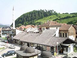 Location of Gornji Vakuf-Uskoplje within Bosnia and Herzegovina.
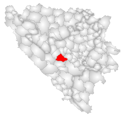 Location of Gornji Vakuf - Uskoplje
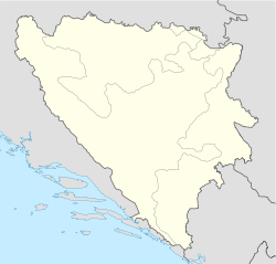
 Gornji Vakuf-Uskoplje
Coordinates: 43°56′N 17°35′E / 43.933°N 17.583°ECoordinates: 43°56′N 17°35′E / 43.933°N 17.583°E Country  Bosnia and Herzegovina
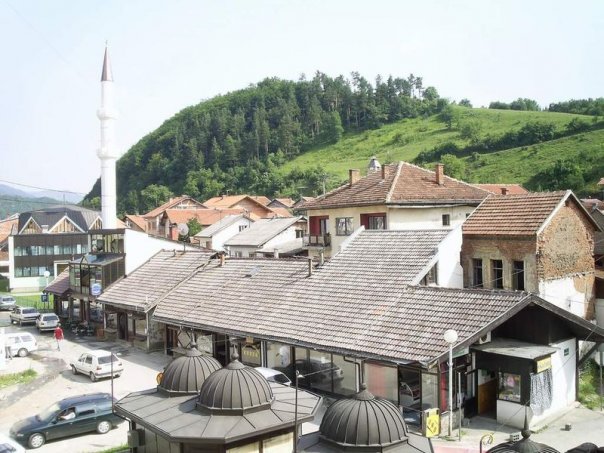
Entity Federation of Bosnia and Herzegovina Government - Municipality president Sead Čaušević (SDA) Area - Total 402 km2 (155.2 sq mi) Population (1991 census) - Total 25,130 - Density 62.5/km2 (161.9/sq mi) Time zone CET (UTC+1) - Summer (DST) CEST (UTC+2) Area code(s) +387 30 Gornji Vakuf-Uskoplje is a town and municipality in Central Bosnia (Bosnia and Herzegovina), located between Bugojno, Prozor, Kupres, Novi Travnik and Konjic. It is under the administration of the Federation of Bosnia and Herzegovina. Although settlement in the area stretches back to prehistoric times, the town with Gornji Vakuf name arose in the 16th century in the location of the existing settlement called Česta. The name Gornji Vakuf refers to the fact that the town was established as a waqf (Vakuf) by Bosniak nobility. Mehmed-beg Stočanin, a famous Bosniak bey, is a founder of Gornji Vakuf. This town is a typical Bosnian čaršija common for Central Bosnia as a heartland of Bosnia and Herzegovina.
Contents
History
Bosnian War
Gornji Vakuf-Uskoplje was made infamous as one of the first towns to suffer from the Croat-Bosniak war (1992-1994) during the Bosnian war (1992-1995) - as a critical node - was vital for UNPROFOR to hold to enable UNHCR supplies to move into the country. It was held by B Company Group 1 CHESHIRE from the British Army during part of early 1993 who lost LCpl Wayne Edwards, who was shot by a Croatian Defence Council (HVO) sniper.[why?][citation needed]
Gornji Vakuf shelling
Gornji Vakuf is a town to the south of the Lašva Valley and of strategic importance at a crossroads en route to Central Bosnia. It is 48 kilometres from Novi Travnik and about one hour’s drive from Vitez in an armoured vehicle. For Croats it was a very important connection between the Lašva Valley and Herzegovina, two territories included in the self-proclaimed Croatian Community of Herzeg-Bosnia. It was first attacked by Croat forces on June 20, 1992, along with Novi Travnik but the attack failed. During the Lašva Valley ethnic cleansing it was surrounded by Croatian Army and Croatian Defence Council and attacked with heavy artillery and other weapons (tanks and snipers). The Croat forces shelling reduced much of the historical oriental center of the town of Gornji Vakuf to rubble.[1]
On January 10, 1993, just before the outbreak of hostilities in Gornji Vakuf, the Croat Defence Council (HVO) commander Luka Šekerija, sent a "Military – Top Secret" request to Colonel Tihomir Blaškić and Dario Kordić (later convicted by ICTY of war crimes and crimes against humanity, i.e. ethnic cleansing) for rounds of mortar shells available at the ammunition factory in Vitez.[2] Fighting then broke out in Gornji Vakuf on January 11, 1993, sparked by a bomb which had been placed by Croats in a Bosniak-owned hotel that had been used as a military headquarters. A general outbreak of fighting followed and there was heavy shelling of the town that night by Croat artillery.[1]
During cease-fire negotiations at the Britbat HQ in Gornji Vakuf, colonel Andrić, representing the HVO, demanded that the Bosnian forces lay down their arms and accept HVO control of the town, threatening that if they did not agree he would flatten Gornji Vakuf to the ground.[1][3] The HVO demands were not accepted by the Bosnian Army and the attack continued, followed by massacres of Bosnian Muslim civilians in the neighbouring villages of Bistrica, Uzričje, Duša, Ždrimci and Hrasnica.[4][5] Although Croats often cited it as a major reason for the attack on Gornji Vakuf, the commander of the British Britbat company claimed that there were no Muslim "holy worriors" (commonly known as Mujahideen) in Gornji Vakuf and that his soldiers did not see any.[1] The shelling campaign and the attackes during the war resulted in hundreds of injured and killed, mostly Bosnian Muslim civilians.
Settlements
• Batuša • Bistrica • Bojska • Boljkovac • Borova Ravan • Crkvice • Cvrče • Dobrošin • Donja Ričica • Dražev Dol • Duratbegov Dolac • Duša • Gaj • Galičica • Gornja Ričica • Gornji Mračaj • Gornji Vakuf • Grnica • Hrasnica • Humac • Jagnjid • Jelače • Jelići • Kozice • Krupa • Kute • Lužani • Mačkovac • Mračaj • Osredak • Pajić Polje • Paloč • Pidriš • Ploča • Podgrađe • Pridvorci • Rosulje • Seferovići • Seoci • Smrčevice • Svilići • Šugine Bare • Uzričje • Vaganjac • Valice • Vilić Polje • Voljevac • Voljice • Vrse • Zastinje i Ždrimci.
Demographics
1971
19.344 total
- Bosnian Muslims (Bosniaks) - 10.482 (54,18%)
- Croats - 8.605 (44,48%)
- Serbs - 141 (0,72%)
- Yugoslavs - 18 (0,09%)
- others - 98 (0,53%)
1991
In the census of 1991, the municipality of Gornji Vakuf-Uskoplje had 25,130 inhabitants: 56.05% Bosniaks, 42.61% Croats, 0.60% Yugoslavs, 0.42% Serbs and 0.31% others.[6]
The town itself had 5,349 residents, of which 61% Bosniaks, 34% Croats, 2% Yugoslavs, 1% Serbs and 1% others.
- Settlement: Bosniaks Srbs Croats Yugos Others Sum B% S% C% Y% O%
- G.Vakuf-1 3278 76 1817 126 52 5349 61% 1% 34% 2% 1%
Ethnicity Number Percent (%) Bosniaks 14063 55.84% Croats 10706 42.51% Yugoslavs 158 0.62% Others 144 0.60% Serbs 110 0.43% TOTAL 25181 100% 2005
It is estimated that the population of municipality in 2005. included 65% Bosniaks and 35% Croats.[citation needed]
Notable persons
References
- ^ a b c d "ICTY: Kordić and Čerkez verdict - IV. Attacks on towns and villages: killings - 2. The Conflict in Gornji Vakuf". http://www.un.org/icty/kordic/trialc/judgement/kor-tj010226e-5.htm#IVA2.
- ^ "ICTY: Kordić and Čerkez verdict - IV. Attacks on towns and villages: killings - 4. Role of Dario Kordić". http://www.un.org/icty/kordic/trialc/judgement/kor-tj010226e-5.htm#IVA4.
- ^ "SENSE Tribunal: Poziv na predaju". http://www.sense-agency.com/ba/stream.php?sta=3&pid=8670&kat=6.
- ^ "SENSE Tribunal: Ko je počeo rat u Gornjem Vakufu". http://www.sense-agency.com/ba/stream.php?sta=3&pid=8652&kat=6.
- ^ "SENSE Tribunal: "James Dean" u Gornjem Vakufu". http://www.sense-agency.com/ba/stream.php?sta=3&pid=8662&kat=6.
- ^ Hdmagazine - Bosnian Census
Municipalities of the Central Bosnia Canton  Categories:
- Populated places in Gornji Vakuf - Uskoplje
- Gornji Vakuf-Uskoplje


Wikimedia Foundation. 2010.