- Crkvice
-
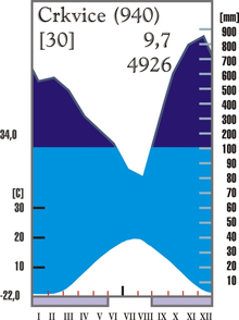
Crkvice (Serbian/Montenegrin Cyrillic: Црквице, pronounced [t͡sř̩kv̞it͡sɛ]) is a village (42.34N 18.38E) on Orjen mountain in Montenegro and is the wettest place in Europe. The average annual precipitation for the period 1931-1960 was 4927 mm (l/m²) and for 1961-1990 4631 mm. The highest amounts per year surpass 7000 mm with an all time historic high at 8036 mm (1937).
Climate
 Meteorological station on Orjen
Crkvice is within the Mediterranean subtropical belt. While summers are hot and sunny, autumn, winter and spring are rainy seasons. A peculiarity of the littoral Dinarids is the precipitation regime as Orjen receives Europe's' most heavy precipitation. Like the monsoon rain it is seasonally distributed, thus November thunderstorms sometimes pour 2000 liters of water in several days, while August is frequently completely dry leading to forest fires.
With a maximum discharge of 350 m³/s water one of the biggest karst springs, the Sopot spring, is a remarkable indicator of this seasonality. Most of the time it is inactive but after heavy rain a remarkable waterfall appears 20 m above the Bay of Kotor.
Station Height [m] Type Character Precipitation [mm] Snow Zubački kabao 1894 Dfsc perhumid Mediterranean snowclimate ca. 6250 ap. 140 days Crkvice 940 Cfsb (fs= without summerdryness), perhumid Mediterranean mountain climate 4926 70 days Risan 0 Cs’’a (s’’= double winter rain season), perhumid Mediterranean coast climate 3500 2 days * classification scheme after Köppen
Two wind systems are noteworthy for their ecological significance: Bura and Jugo. Strong cold downslope winds of Bura type appear in winter and are most severe in the Bay of Risan. Gusts reach 250 km/h and can lead to a significant fall of temperatures in several hours with freezing events problematic for most of the Mediterranean cultures. Bura weather situations are frequent and sailors keep an eye on the mountains as cap clouds indicate an eminent Bura event. Jugo is a warm humid rain and is important as it brings heavy rain. It appears throughout the year but is usually centered in autumn and spring.
Station Period Height [m] I II III IV V VI VII VIII IX X XI XII I-XII [mm/a] Herceg Novi 1961-1984 40 230 221 183 135 130 73 28 45 160 181 326 262 1974 Risan 1961-1984 40 405 342 340 235 153 101 66 123 188 295 423 434 3105 Grahovo 1961-1984 710 351 324 305 251 142 94 55 103 202 416 508 473 3224 Podvrsnik 1961-1984 630 407 398 367 305 151 101 77 132 238 465 593 586 3820 Vrbanje 1961-1984 1010 472 390 388 321 181 104 70 122 224 369 565 536 3742 Knezlaz 1961-1984 620 547 472 473 373 207 120 72 136 268 400 629 661 4358 Crkvice 1961-1984 940 610 499 503 398 198 135 82 155 295 502 714 683 4774 Ivan. Korita 1960-1984 1350 434 460 742 472 128 198 74 46 94 300 694 972 4614 Goli vrh 1893-1913 1311 271 286 307 226 188 148 75 70 215 473 415 327 3129 Jankov vrh 1890-1909 1017 424 386 389 346 212 124 55 58 202 484 579 501 3750 Cetinje 1961-1984 655 434 357 367 288 164 92 72 118 209 306 489 498 3394 Grab-Zubci 1934-1960 677 333 325 257 195 183 83 59 86 173 360 447 485 2985 Trebinje 1931-1960 276 193 190 160 102 119 70 43 76 110 239 247 249 1762 Dubrovnik 1931-1960 49 147 113 102 92 79 60 24 38 97 156 213 186 1307 * monthly and yearly precipitation ranges in Dalmatia, Herzegovina and Montenegro
Categories:- Geography of Montenegro
- Climate by city

Wikimedia Foundation. 2010.