- Osmaci
-
Osmaci
ОсмациLocation of Osmaci within Bosnia and Herzegovina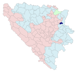
Country Bosnia and Herzegovina Government – Mayor Zoran Riđošić (acting) Population (1991)[citation needed] – Total 2,628 – Municipality ? Time zone CET (UTC+1) – Summer (DST) CEST (UTC+2) Area code(s) 56 Osmaci (Serbian Cyrillic: Осмаци) is a village and a municipality located in eastern Bosnia and Herzegovina in the Republika Srpska entity of BiH.
Contents
History
The municipality was created from part of the territory of the pre-war municipality of Kalesija that was assigned to Republika Srpska by the Dayton Agreement (the other part of the pre-war municipality is now in the Federation of Bosnia and Herzegovina).
Demographics
In 1991, the population of the Osmaci village numbered 2,628 people, including:
- 1,535 Serbs (58%) (See: Serbs of Bosnia and Herzegovina)
- 1,087 Muslims by nationality (41%)
See also
External links
Categories:- Bosnia and Herzegovina geography stubs
- Populated places in Osmaci
- Cities and towns in Republika Srpska
- Municipalities of Republika Srpska

Wikimedia Foundation. 2010.