- Modriča
-
Coordinates: 44°57′24″N 18°18′54″E / 44.95667°N 18.315°E
Modriča
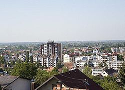
МодричаView on Modriča 
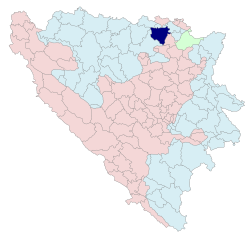
Coat of armsLocation of Modriča within Republika Srpska Coordinates: 44°57′24″N 18°18′54″E / 44.95667°N 18.315°E Entity  Republika Srpska
Government - Mayor Mladen Krekić (SNSD) [1] Area - Total 336 km2 (129.7 sq mi) Population (1991) - Total 35,413 - Municipality ? Time zone CET (UTC+1) - Summer (DST) CEST (UTC+2) Area code(s) 53 Website www.modrica.ba Modriča (Serbian Cyrillic: Модрича) is a city and municipality in Bosnia and Herzegovina, in Republika Srpska entity. It is located near the towns of Šamac, Derventa and Doboj. After the war, prewar municipal borders were changed, villages of Jakeš, Pećnik and Modrički Lug were excluded from Modriča and included in new Vukosavlje municipality), and few villages from western part of prewar Gradačac municipality were included. So the area of municiplity changed substantially.
Contents
Demographics
1971
31,622 total
- Serbs - 13,457 (42.55 %)
- Croats - 9,418 (29.78 %)
- Bosniaks - 8,356 (26.42 %)
- Yugoslavs - 180 (0.56 %)
- оthers - 211 (0.69 %)
1991
According to the 1991 census, the Modriča municipality had a population of 35,413 people, including[1]:
Economy
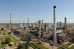
The Modriča oil refinery, currently owned by Russian investors, is located in Modriča.
Sports
- The local football club, FK Modriča, plays in the First League of the Republika Srpska.
- The local volleyball club is Modriča Optima.
Car racing club OPTIMA - MODRICA
See also
References
External links
Historic Photos of Modriča
- Old photograph of Modriča - year unknown (#1)
- Old photograph of Modriča - year unknown (#2)
- Photograph of "Alibeg's Cafe", destroyed in 1946
- A photograph of Modriča in the 1970s
- An Austro-Hungarian map of Modriča and the surrounding area - from the end of the 19th century
Other links
Categories:- Populated places in Modriča
- Cities and towns in Republika Srpska
- Municipalities of Republika Srpska
Wikimedia Foundation. 2010.


