- National Register of Historic Places listings in Surry County, Virginia
-
This list includes properties and districts listed on the National Register of Historic Places in Surry County, Virginia. Click the "Map of all coordinates" link to the right to view a Google map of all properties and districts with latitude and longitude coordinates in the table below.[1]
-
- This National Park Service list is complete through NPS recent listings posted November 10, 2011.[2]
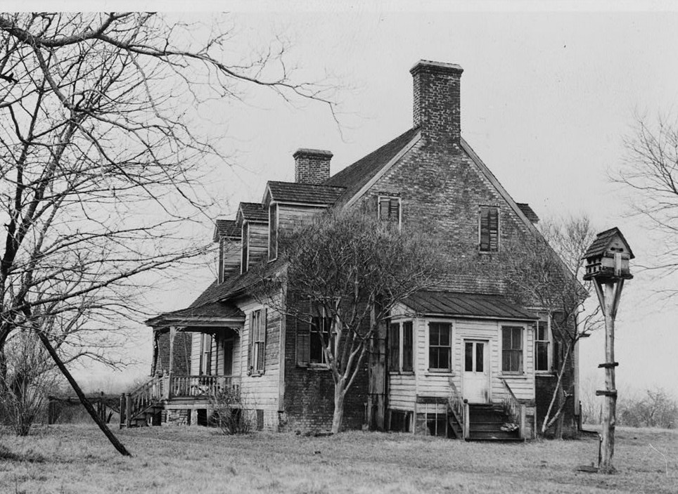
[3] Landmark name[4] Image Date listed Location City or Town Summary 1 Bacon's Castle 
October 15, 1966 Off VA 10
37°6′39″N 76°43′12″W / 37.11083°N 76.72°WBacon's Castle 2 Cedar Ridge August 2, 2000 4861 Laurel Dr.
37°6′40″N 77°6′46″W / 37.11111°N 77.11278°WDisputanta 3 Chippokes Plantation October 1, 1969 Chippokes State Park, Virginia 634 and 633
37°8′11″N 76°43′38″W / 37.13639°N 76.72722°WJamestown 4 Enos House December 7, 1977 Address Restricted Surry 5 Four Mile Tree 
December 18, 1970 NE of the jct. of VA 618 and VA 610
37°12′2″N 76°51′21″W / 37.20056°N 76.85583°WSurry 6 Glebe House of Southwark Parish May 17, 1976 E of Spring Grove on VA 10
37°8′27″N 76°54′17″W / 37.14083°N 76.90472°WSpring Grove 7 Melville May 6, 1980 E of Surry
37°8′31″N 76°47′24″W / 37.14194°N 76.79°WSurry 8 Montpelier March 26, 1980 1.4 mi. SW of Cabin Point
37°10′19″N 77°3′9″W / 37.17194°N 77.0525°WCabin Point 9 Old Brick Church January 2, 1986 VA 10
37°6′30″N 76°44′9″W / 37.10833°N 76.73583°WBacon's Castle 10 Pleasant Point 
July 16, 1976 1 mi. S of Scotland on VA 637
37°10′25″N 76°46′32″W / 37.17361°N 76.77556°WScotland 11 Rich Neck Farm May 19, 1980 E of Surry
37°7′33″N 76°45′5″W / 37.12583°N 76.75139°WSurry 12 Rogers' Store May 30, 2002 Jct. of VA 615 and VA 612
37°5′44″N 77°0′15″W / 37.09556°N 77.00417°WSurry 13 Second Southwark Church Archeological Site (44SY65) February 23, 1984 Address Restricted Surry 14 Smith's Fort 
June 15, 1970 Address Restricted Surry 15 Snow Hill December 28, 1979 VA 40
37°5′19″N 77°2′58″W / 37.08861°N 77.04944°WGwaltney Corner 16 Surry County Courthouse Complex April 10, 1986 VA 10
37°8′14″N 76°50′7″W / 37.13722°N 76.83528°WSurry 17 Swann's Point Plantation Site April 1, 1975 Address Restricted Scotland 18 Warren House November 14, 1973 NE of Surry off VA 31
37°9′44″N 76°49′22″W / 37.16222°N 76.82278°WSurry See also
- National Register of Historic Places listings in Virginia
- List of National Historic Landmarks in Virginia
References
- ^ The latitude and longitude information provided in this table was derived originally from the National Register Information System, which has been found to be fairly accurate for about 99% of listings. For about 1% of NRIS original coordinates, experience has shown that one or both coordinates are typos or otherwise extremely far off; some corrections may have been made. A more subtle problem causes many locations to be off by up to 150 yards, depending on location in the country: most NRIS coordinates were derived from tracing out latitude and longitudes off of USGS topographical quadrant maps created under North American Datum of 1927, which differs from the current, highly accurate GPS system used by Google maps. Chicago is about right, but NRIS longitudes in Washington are higher by about 4.5 seconds, and are lower by about 2.0 seconds in Maine. Latitudes differ by about 1.0 second in Florida. Some locations in this table may have been corrected to current GPS standards.
- ^ "National Register of Historic Places: Weekly List Actions". National Park Service, United States Department of the Interior. Retrieved on November 10, 2011.
- ^ Numbers represent an ordering by significant words. Various colorings, defined here, differentiate National Historic Landmark sites and National Register of Historic Places Districts from other NRHP buildings, structures, sites or objects.
- ^ "National Register Information System". National Register of Historic Places. National Park Service. 2008-04-24. http://nrhp.focus.nps.gov/natreg/docs/All_Data.html.
U.S. National Register of Historic Places Topics Lists by states Alabama • Alaska • Arizona • Arkansas • California • Colorado • Connecticut • Delaware • Florida • Georgia • Hawaii • Idaho • Illinois • Indiana • Iowa • Kansas • Kentucky • Louisiana • Maine • Maryland • Massachusetts • Michigan • Minnesota • Mississippi • Missouri • Montana • Nebraska • Nevada • New Hampshire • New Jersey • New Mexico • New York • North Carolina • North Dakota • Ohio • Oklahoma • Oregon • Pennsylvania • Rhode Island • South Carolina • South Dakota • Tennessee • Texas • Utah • Vermont • Virginia • Washington • West Virginia • Wisconsin • WyomingLists by territories Lists by associated states Other Municipalities and communities of Surry County, Virginia Towns 
CDP Categories:- Surry County, Virginia
- National Register of Historic Places in Virginia
- Virginia-related lists
-


Wikimedia Foundation. 2010.