- National Register of Historic Places listings in Northampton County, Virginia
-
This list includes properties and districts listed on the National Register of Historic Places in Northampton County, Virginia. Click the "Map of all coordinates" link to the right to view a Google map of all properties and districts with latitude and longitude coordinates in the table below.[1]
-
- This National Park Service list is complete through NPS recent listings posted November 10, 2011.[2]
[3] Landmark name [4] Image Date listed Location City or town Summary 1 Almshouse Farm at Machipongo April 1, 2002 12402 Lankford Hwy.
37°24′15″N 75°54′21″W / 37.404167°N 75.905833°WMachipongo 2 Arlington Archeological Site May 12, 2008 Address Restricted Capeville 3 Benjamin's Department Store May 10, 2006 3327 Main St.
37°32′01″N 75°49′20″W / 37.533611°N 75.822222°WExmore 4 James Brown's Dry Goods Store April 1, 2002 16464 Courthouse Rd.
37°21′06″N 75°56′51″W / 37.351667°N 75.9475°WEastville 5 Brownsville 
February 26, 1970 SW of jct. of Rtes. 608 and 600
37°28′04″N 75°49′35″W / 37.467778°N 75.826389°WNassawadox 6 Cape Charles Historic District January 3, 1991 Roughly bounded by Washington, Bay and Mason Aves. and Fig St.
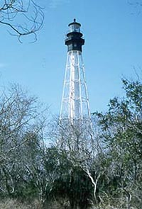
37°16′11″N 76°00′59″W / 37.269722°N 76.016389°WCape Charles 7 Cape Charles Light Station 
June 23, 2003 Smith Island
37°07′22″N 75°54′24″W / 37.122778°N 75.906667°WKiptopeke 8 Cessford 
January 16, 2004 16546 Courthouse Rd.
37°20′59″N 75°56′54″W / 37.349722°N 75.948333°WEastville 9 John W. Chandler House November 27, 2004 3342 Main St.
37°31′56″N 75°49′23″W / 37.532222°N 75.823056°WExmore 10 Custis Tombs April 17, 1970 NW of jct. of Rtes. 644 and 645
37°13′44″N 76°00′14″W / 37.228889°N 76.003889°WCheapside 11 Eastville Historic District 
October 1, 2009 Area includes VA Rt. 13, Old Town Neck Dr., Courthouse Rd., Willow Oak Rd., Rockefellow La., and Stumptown Dr.
37°21′09″N 75°56′45″W / 37.352636°N 75.945764°WEastville 12 Eastville Mercantile January 20, 2005 16429 Courthouse Rd.
37°21′16″N 75°56′46″W / 37.354444°N 75.946111°WEastville 13 Eyre Hall 
November 12, 1969 N of jct. of Rte. 680 and U.S. 13
37°18′35″N 75°58′29″W / 37.309722°N 75.974722°WCheriton 14 Glebe of Hungar's Parish February 26, 1970 NW of jct. of Rtes. 622 and 619
37°27′36″N 75°57′44″W / 37.46°N 75.962222°WFranktown 15 Grapeland May 6, 1980 Grapeland Circle, north of Wardtown
37°32′40″N 75°52′55″W / 37.54444°N 75.88194°W[5]Wardtown 16 Hungars Church 
October 15, 1970 E of jct. of Rtes. 619 and 622
37°26′46″N 75°55′27″W / 37.446111°N 75.924167°WBridgetown 17 Kendall Grove 
June 21, 1982 VA 674
37°22′56″N 75°56′35″W / 37.382222°N 75.943056°WEastville 18 Northampton County Courthouse Historic District April 13, 1972 E. by Rt.13 & extending from Rt. 13 .1 mi. west, & extendingfrom the intersection of Rt. 631 .1 mi north & .1 mi. south
37°21′10″N 75°56′48″W / 37.352778°N 75.946667°WEastville 19 Northampton Lumber Company Historic District May 29, 2008 Jct. of VA 912 & US 13
37°28′26″N 75°51′30″W / 37.474006°N 75.858408°WNassawadox 20 Oak Grove February 4, 1993 VA 630 N side, 1 mi. W of jct. with US 13
37°22′48″N 75°57′23″W / 37.38°N 75.956389°WEastville 21 Pear Valley 
November 12, 1969 S of jct. of Rtes. 689 and 628
37°23′48″N 75°55′29″W / 37.396667°N 75.924722°WEastville 22 Selma May 10, 2006 16237 Courthouse Rd.
37°21′32″N 75°56′32″W / 37.358889°N 75.942222°WEastville 23 Stratton Manor 
November 28, 1980 SE of Cape Charles off VA 642
37°15′43″N 75°59′02″W / 37.261944°N 75.983889°WCape Charles 24 Upper Ridge Site August 23, 2005 Address Restricted Mockhorn Island 25 Vaucluse 
September 15, 1970 S of jct. of Rtes. 619 and 657
37°25′42″N 75°58′41″W / 37.428333°N 75.978056°WBridgetown 26 Westerhouse House November 19, 1974 W of Bridgetown off VA 619
37°26′56″N 75°58′10″W / 37.448889°N 75.969444°WBridgetown 27 Winona October 1, 1969 NE of jct. of Rtes. 619 and 622
37°26′42″N 75°56′02″W / 37.445°N 75.933889°WBridgetown See also
- National Register of Historic Places listings in Virginia
- List of National Historic Landmarks in Virginia
References
- ^ The latitude and longitude information provided in this table was derived originally from the National Register Information System, which has been found to be fairly accurate for about 99% of listings. For about 1% of NRIS original coordinates, experience has shown that one or both coordinates are typos or otherwise extremely far off; some corrections may have been made. A more subtle problem causes many locations to be off by up to 150 yards, depending on location in the country: most NRIS coordinates were derived from tracing out latitude and longitudes off of USGS topographical quadrant maps created under North American Datum of 1927, which differs from the current, highly accurate GPS system used by Google maps. Chicago is about right, but NRIS longitudes in Washington are higher by about 4.5 seconds, and are lower by about 2.0 seconds in Maine. Latitudes differ by about 1.0 second in Florida. Some locations in this table may have been corrected to current GPS standards.
- ^ "National Register of Historic Places: Weekly List Actions". National Park Service, United States Department of the Interior. Retrieved on November 10, 2011.
- ^ Numbers represent an ordering by significant words. Various colorings, defined here, differentiate National Historic Landmark sites and National Register of Historic Places Districts from other NRHP buildings, structures, sites or objects.
- ^ "National Register Information System". National Register of Historic Places. National Park Service. . http://nrhp.focus.nps.gov/natreg/docs/All_Data.html.
- ^ Location derived from its coordinates; the NRIS lists the site as "Address Restricted" but provides coordinates
U.S. National Register of Historic Places Topics Lists by states Alabama • Alaska • Arizona • Arkansas • California • Colorado • Connecticut • Delaware • Florida • Georgia • Hawaii • Idaho • Illinois • Indiana • Iowa • Kansas • Kentucky • Louisiana • Maine • Maryland • Massachusetts • Michigan • Minnesota • Mississippi • Missouri • Montana • Nebraska • Nevada • New Hampshire • New Jersey • New Mexico • New York • North Carolina • North Dakota • Ohio • Oklahoma • Oregon • Pennsylvania • Rhode Island • South Carolina • South Dakota • Tennessee • Texas • Utah • Vermont • Virginia • Washington • West Virginia • Wisconsin • WyomingLists by territories Lists by associated states Other  Category:National Register of Historic Places •
  Portal:National Register of Historic PlacesCategories:
- Northampton County, Virginia
- National Register of Historic Places in Virginia
- Virginia-related lists
-


Wikimedia Foundation. 2010.