- Regions and Divisions of Maharashtra
-

The Indian state of Maharashtra came into existence on May 1, 1960 (also known as Maharashtra Day), initially with 28 districts. 7 new districts have been created since then and currently the number of districts in the state is 35. These districts are grouped into six administrative divisions.
Contents
Regions and Divisions
Maharashtra is divided into thirty-five districts, which are grouped into six divisions.[1] These are official revenue divisions of government of Maharashtra.
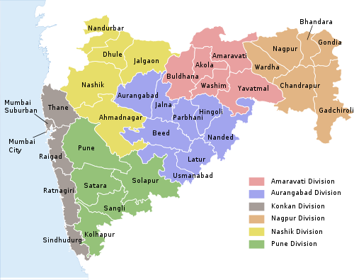 Districts and divisions of Maharashtra
Regions
Geographically, historically and according to political sentiments, Maharashtra has five main regions:
- Vidarbha Region - (Nagpur and Amravati divisions) - (Old Berar Region)
- Marathwada Region - (Aurangabad Division)
- Khandesh and Northern Maharashtra Region - (Nashik Division)
- Desh or Western Maharashtra Region - (Pune Division)
- Konkan - (Mumbai Division)
Divisions
Name of Division
(Headquarter)Region Districts Largest City Amravati Division
(HQ: Amravati)Vidarbha Akola
Amravati
Buldhana
Yavatmal
WashimAmravati Aurangabad Division
(HQ: Aurangabad)Marathwada Aurangabad
Beed
Hingoli
Jalna
Latur
Nanded
Osmanabad
ParbhaniAurangabad Mumbai Division
(HQ: Mumbai)Mumbai Mumbai
Mumbai Suburban District
Thane
Raigad
Ratnagiri
SindhudurgMumbai Nagpur Division
(HQ: Nagpur)Vidarbh Bhandara
Chandrapur
Gadchiroli
Gondia
Nagpur
WardhaNagpur Nashik Division
(HQ: Nashik)Khandesh and Northern Maharashtra Ahmednagar
Dhule
Jalgaon
Nandurbar
NashikNashik Pune Division
(HQ: Pune)Desh or Western Maharashtra Kolhapur
Pune
Sangli
Satara
SolapurPune Districts
The table below lists important geographic and demographic parameters for all 35 districts. Population data is extracted from the 2001 Census of India.
Name Code Formed Headquarters Administrative
DivisionArea (km2) Population
(2001 census)% of State
PopulationDensity
(per km2)Urban (%) Literacy (%) Sex Ratio Tehsils Source Ahmednagar AH 1 May 1960 Ahmednagar Nashik 17,413 40,88,077 4.23% 234.77 19.67 75.82 941 14 District website Akola AK 1 May 1960 Akola Amravati 5,417 16,30,239 1.68% 300.78 38.49 81.41 938 7 District website Amravati AM 1 May 1960 Amravati Amravati 12,626 26,06,063 2.69% 206.40 34.50 82.5 938 14 District website Aurangabad AU 1 May 1960 Aurangabad Aurangabad 10,100 28,97,013 2.99% 286.83 37.53 61.15 924 9 District website Beed BI 1 May 1960 Beed Aurangabad 10,439 21,61,250 2.23% 207.04 17.91 68 936 11 District website Bhandara BH 1 May 1960 Bhandara Nagpur 3,717 11,35,835 1.17% 305.58 15.44 68.28 982 7 District website Buldhana BU 1 May 1960 Buldhana Amravati 9,680 22,32,480 2.31% 230.63 21.2 75.8 946 13 District website Chandrapur CH 1 May 1960 Chandrapur Nagpur 10,695 20,71,101 2.14% 193.65 32.11 73.03 948 15 District website Dhule DH 1 May 1960 Dhule Nashik 8,063 17,07,947 1.77% 211.83 26.11 71.6 944 4 District website Gadchiroli GA 26 August 1982 Gadchiroli Nagpur 14,412 9,70,294 1% 67.33 6.93 60.1 976 12 District website Gondia GO 1 May 1999 Gondia Nagpur 4,843 12,00,151 1.24% 247.81 11.95 67.67 1005 8 District website Hingoli HI 1 May 1999 Hingoli Aurangabad 4,526 9,87,160 1.02% 218.11 15.2 66.86 953 5 District website Jalgaon JG 1 May 1960 Jalgaon Nashik 11,765 36,79,936 3.8% 312.79 71.4 76.06 932 15 District website Jalna JN 1 May 1960 Jalna Aurangabad 7,612 16,12,357 1.67% 211.82 19.09 64.52 952 8 District website Kolhapur KO 1 May 1960 Kolhapur Pune 7,685 35,15,413 3.63% 457.44 29.65 77.23 949 10 District website Latur LA 1 May 1960 Latur Aurangabad 7,372 20,80,285 2.15% 282.19 23.57 71.54 935 10 District website Mumbai City MC 1 May 1960 Mumbai Konkan 67.7 33,26,837 3.44% 49,140.9 100 86.4 777 0 District website Mumbai Suburban MU 1 October 1990 Bandra (East) Konkan 369 85,87,000 8.88% 23,271 100 86.9 822 3 District website Nagpur NG 1 May 1960 Nagpur Nagpur 9,897 40,51,444 4.19% 409.36 64.33 84.18 933 13 District website Nanded ND 1 May 1960 Nanded Aurangabad 10,422 28,76,259 2.97% 275.98 28.29 68.52 942 16 District website Nandurbar NB 1 July 1998 Nandurbar Nashik 5,035 13,09,135 1.35% 260 15.5 46.63 975 6 District website Nashik NS 1 May 1960 Nashik Nashik 15,530 49,93,796 5.16% 321.56 38.8 74.4 927 15 District website Osmanabad OS 1 May 1960 Osmanabad Aurangabad 7,512 14,86,586 1.54% 197.89 15.7 54.27 932 8 District website Parbhani PA 1 May 1960 Parbhani Aurangabad 6,251 15,27,715 1.58% 244.4 31.8 55.15 958 9 District website Pune PU 1 May 1960 Pune Pune 15,642 72,24,224 7.47% 461.85 58.1 80.78 919 14 District website Raigad RG 1 May 1960 Alibag Konkan 7,148 22,07,929 2.28% 308.89 24.2 77 976 15 District website Ratnagiri RT 1 May 1960 Ratnagiri Konkan 8,208 16,96,777 1.75% 206.72 11.3 65.13 1,136 9 District website Sangli SN 1 May 1960 Sangli Pune 8,578 25,83,524 2.67% 301.18 24.5 62.41 957 10 District website Satara ST 1 May 1960 Satara Pune 10,484 27,96,906 2.89% 266.77 14.2 78.52 995 11 District website Sindhudurg SI 1 May 1981 Oros Konkan 5,207 8,68,825 0.9% 166.86 9.5 80.3 1,079 8 District website Solapur SO 1 May 1960 Solapur Pune 14,845 38,49,543 3.98% 259.32 31.8 71.2 935 11 District website Thane TH 1 May 1960 Thane Konkan 9,558 81,31,849 8.4% 850.71 72.58 80.67 858 15 District website Wardha WR 1 May 1960 Wardha Nagpur 6,310 12,30,640 1.27% 195.03 25.17 80.5 936 8 District website Washim WS 1 July 1998 Washim Amravati 5,150 10,20,216 1.05% 275.98 17.49 74.02 939 6 District website Yavatmal YA 1 May 1960 Yavatmal Amravati 13,582 20,77,144 2.15% 152.93 18.6 57.96 951 16 District website Maharashtra - - - - 3,07,713 9,68,78,627 - 314.42 42.43 77.27 922 - - References
See also
Tehsils in Maharashtra Maharashtra
 State of Maharashtra
Capital : Mumbai Topics Regions Desh · Khandesh · Konkan · Mumbai Metropolitan Region · Marathwada · Vidarbha
Districts Ahmednagar · Akola · Amravati · Aurangabad · Beed · Bhandara · Buldhana · Chandrapur · Dhule · Gadchiroli · Gondia · Hingoli · Jalgaon · Jalna · Kolhapur · Latur · Mumbai (City) · Mumbai (Suburban) · Nagpur · Nanded · Nandurbar · Nashik · Osmanabad · Parbhani · Pune · Raigad · Ratnagiri · Sangli · Satara · Sindhudurg · Solapur · Thane · Wardha · Washim · Yavatmal
Million-plus Cities
in MaharashtraMumbai · Pune · Nagpur · Thane · Pimpri-Chinchwad · Nashik · Kalyan-Dombivali · Navi Mumbai · Aurangabad
Other Cities with
Municipal CorporationsAhmednagar · Akola · Amravati · Bhiwandi · Chandrapur · Dhule · Jalgaon · Kolhapur · Latur · Malegaon · Mira-Bhayandar · Nanded · Parbhani · Solapur · Ulhasnagar · Vasai-Virar ·
Portal : Maharashtra Districts of States of India States Andhra Pradesh · Arunachal Pradesh · Assam · Bihar · Chhattisgarh · Goa · Gujarat · Haryana · Himachal Pradesh · Jammu and Kashmir · Jharkhand · Karnataka · Kerala · Madhya Pradesh · Maharashtra · Manipur · Meghalaya · Mizoram · Nagaland · Orissa · Punjab · Rajasthan · Sikkim · Tamil Nadu · Tripura · Uttar Pradesh · Uttarakhand · West Bengal
Union Territories Andaman and Nicobar Islands · Chandigarh · Dadra and Nagar Haveli · National Capital Territory of Delhi · Daman and Diu · Lakshadweep · PuducherryRelated topics List of states and territories of India · District collector · Sub-Divisional Magistrate · Community Development Block · Block Development Officer · Gram panchayatCategories:- Districts of Maharashtra
- Maharashtra-related lists


Wikimedia Foundation. 2010.