- Culloden, West Virginia
-
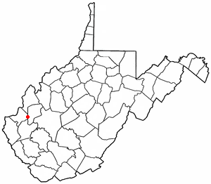
Culloden, West Virginia — CDP — Location of Culloden, West Virginia
Coordinates: 38°25′6″N 82°4′4″W / 38.41833°N 82.06778°WCoordinates: 38°25′6″N 82°4′4″W / 38.41833°N 82.06778°W Country United States State West Virginia Counties Cabell, Putnam Area[1] – Total 4.2 sq mi (10.9 km2) – Land 4.2 sq mi (10.9 km2) – Water 0.0 sq mi (0.0 km2) Elevation 705 ft (215 m) Population (2010)[2] – Total 3,061 – Density 728.8/sq mi (280.8/km2) Time zone Eastern (EST) (UTC-5) – Summer (DST) EDT (UTC-4) ZIP code 25510 Area code(s) 304 FIPS code 54-19516[3] GNIS feature ID 1554240[4] Culloden is a census-designated place (CDP) in West Virginia. Most of Culloden is in Cabell County, with the remainder in Putnam County. As of the 2010 census, the CDP population was 3,061 (2,683 in Cabell County, 378 in Putnam County). The Cabell County portion of Culloden is part of the Huntington-Ashland, WV-KY-OH Metropolitan Statistical Area, while the Putnam County portion is considered part of the Charleston, WV Metropolitan Statistical Area.
The community was named by L. R. White, who lost a leg while working for the Chesapeake and Ohio Railroad. White was asked to name the town upon the establishment of its post office and train station; he suggested "Culloden" because there were so few places with that name in the United States.[5]
Geography
Culloden is located at 38°25′6″N 82°4′4″W / 38.41833°N 82.06778°W (38.418238, -82.067883)[1].
According to the United States Census Bureau, the Culloden CDP has a total area of 4.2 square miles (10.9 km²), of which, 4.2 square miles (10.9 km²) of it is land and 0.38% is water.
Demographics
As of the census[3] of 2000, there were 2,940 people, 1,177 households, and 894 families residing in the community. The population density was 796.8 people per square mile (307.6/km²). There were 1,249 housing units at an average density of 338.5/sq mi (130.7/km²). The racial makeup of the community was 98.84% White, 0.31% African American, 0.10% Native American, 0.27% Asian, 0.03% from other races, and 0.44% from two or more races. Hispanic or Latino of any race were 0.24% of the population.
There were 1,177 households out of which 32.6% had children under the age of 18 living with them, 62.8% were married couples living together, 10.6% had a female householder with no husband present, and 24.0% were non-families. 21.0% of all households were made up of individuals and 10.5% had someone living alone who was 65 years of age or older. The average household size was 2.49 and the average family size was 2.87.
The age distribution is 22.3% under the age of 18, 8.8% from 18 to 24, 28.4% from 25 to 44, 26.5% from 45 to 64, and 14.0% who were 65 years of age or older. The median age was 38 years. For every 100 females there were 91.2 males. For every 100 females age 18 and over, there were 85.8 males.
The median income for a household in the community was $39,135, and the median income for a family was $42,365. Males had a median income of $35,625 versus $21,050 for females. The per capita income for the community was $18,904. About 5.3% of families and 8.0% of the population were below the poverty line, including 19.9% of those under age 18 and 6.6% of those age 65 or over.
References
- ^ a b "US Gazetteer files: 2010, 2000, and 1990". United States Census Bureau. 2011-02-12. http://www.census.gov/geo/www/gazetteer/gazette.html. Retrieved 2011-04-23.
- ^ "American FactFinder". United States Census Bureau. http://factfinder2.census.gov. Retrieved 2011-05-14.
- ^ a b "American FactFinder". United States Census Bureau. http://factfinder.census.gov. Retrieved 2008-01-31.
- ^ "US Board on Geographic Names". United States Geological Survey. 2007-10-25. http://geonames.usgs.gov. Retrieved 2008-01-31.
- ^ Kenny, Hamill (1945). West Virginia Place Names: Their Origin and Meaning, Including the Nomenclature of the Streams and Mountains. Piedmont, West Virginia: The Place Name Press. pp. 194.
Municipalities and communities of Cabell County, West Virginia City 
Town Village CDPs Other
communitiesFootnotes ‡This populated place also has portions in an adjacent county or counties
Municipalities and communities of Putnam County, West Virginia Cities 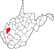
Towns CDPs Culloden‡ | Hometown | Teays Valley
Other
localitiesBlack Betsy | Confidence | Fraziers Bottom | Lanham | Liberty | Midway | Morgans Landing | Mt. Vernon | Nye | Pliny | Plymouth | Raymond City | Red House | Robertsburg | Scary | Scott Depot | Teays
Footnotes ‡This populated place also has portions in an adjacent county or counties
Huntington–Ashland, WV–KY–OH, Metropolitan Statistical Area Principal cities 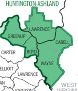
Municipalities with population
over 5,000Municipalities with population
1,000-5,000Barboursville • Burlington • Catlettsburg • Ceredo • Coal Grove • Culloden CDP • Greenup • Kenova • Milton • Raceland • Russell • South Point • South Shore • Wayne • Westwood CDP • Worthington • WurtlandMunicipalities with population
under 1,000West Virginia counties Kentucky counties Ohio counties Categories:- Populated places in Cabell County, West Virginia
- Populated places in Putnam County, West Virginia
- Unincorporated communities in West Virginia
- Census-designated places in West Virginia
- Huntington–Ashland metropolitan area
- Charleston, West Virginia metropolitan area


Wikimedia Foundation. 2010.