- Mesa Grande
-
Mesa Grande

Nearest city: Mesa, Arizona Governing body: Public NRHP Reference#: 78000549
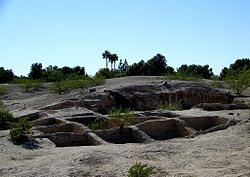
[1]Added to NRHP: November 21, 1978 Mesa Grande ruins, in Mesa, Arizona, preserves a group of Hohokam structures constructed during the classical period. The ruins were occupied between AD 1100 and 1400 (Pueblo II - Pueblo IV Era) and were a product of the Hohokam civilization that inhabited the Salt River Valley. There the Hohokam constructed an extensive system of water canals before vanishing for mysterious reasons. It is one of only two remaining Hohokam mounds remaining in the metro Phoenix area, with the other being the Pueblo Grande Museum Archaeological Park. The site's central feature is a massive ruin of adobe walls and platforms.[2][3]
It was listed on the National Register of Historic Places in 1978[1] when it was owned by B-movie actress Acquanetta. The site was acquired from her in 1988 by the city of Mesa.[4]
At the present time, the ruin is not open to the public but can be seen through the fence. The Arizona Museum of Natural History is currently undertaking archaeological studies at the site, and is working on opening it to the public.[5] The mound remains remarkably intact. The general site remains protected but undeveloped.
The ruins are located to the west and across the street from the former Mesa Lutheran Hospital, now a Banner Health corporate center housing billing and Information Technology employees.
Artifacts presumably associated with the ruins have been found in the neighborhood to the west. Axe heads, arrow heads, and pottery sherds were regularly uncovered and collected by residents during the 1960s and 1970s just under the surface of the earth in private property there.[citation needed]
Contents
Gallery
See also
References
- ^ a b "National Register Information System". National Register of Historic Places. National Park Service. 2008-04-15. http://nrhp.focus.nps.gov/natreg/docs/All_Data.html.
- ^ "Flat Stanley at Mesa Grande". Archaeological Research Institute, Arizona State University. http://archaeology.asu.edu/vm/Education/stanley/pages/grande.htm. Retrieved 2011-03-21.
- ^ "Mesa Grande". City of Mesa. 2002. http://www.azmnh.org/arch/mesagrande.aspx. Retrieved 2011-10-13.
- ^ "Acqua Blues". Phoenix New Times. September 2, 2004. http://www.phoenixnewtimes.com/2004-09-02/culture/acqua-blues/. Retrieved 2011-08-29.
- ^ "Application for Arizona Centennial 2012 Legacy Project Designation: Mesa Verde". AZ Centennial. http://www.azcentennial.gov/projects/applications/AHAC20-08.pdf. Retrieved 2011-10-13.
External links
 Media related to Mesa Grande at Wikimedia Commons
U.S. National Register of Historic Places Topics Lists by states Alabama • Alaska • Arizona • Arkansas • California • Colorado • Connecticut • Delaware • Florida • Georgia • Hawaii • Idaho • Illinois • Indiana • Iowa • Kansas • Kentucky • Louisiana • Maine • Maryland • Massachusetts • Michigan • Minnesota • Mississippi • Missouri • Montana • Nebraska • Nevada • New Hampshire • New Jersey • New Mexico • New York • North Carolina • North Dakota • Ohio • Oklahoma • Oregon • Pennsylvania • Rhode Island • South Carolina • South Dakota • Tennessee • Texas • Utah • Vermont • Virginia • Washington • West Virginia • Wisconsin • WyomingLists by territories Lists by associated states Other  Category:National Register of Historic Places •
  Portal:National Register of Historic PlacesCategories:
- Puebloan buildings and structures
- Archaeological sites on the National Register of Historic Places in Arizona
- Buildings and structures in Mesa, Arizona
- Native American history of Arizona
- Native American pottery
- Oasisamerica cultures
- Protected areas of Maricopa County, Arizona
- Arizona Registered Historic Place stubs
- United States archaeology stubs
Wikimedia Foundation. 2010.


