- Orangeville, Illinois
-
For other places with the same name, see Orangeville (disambiguation).
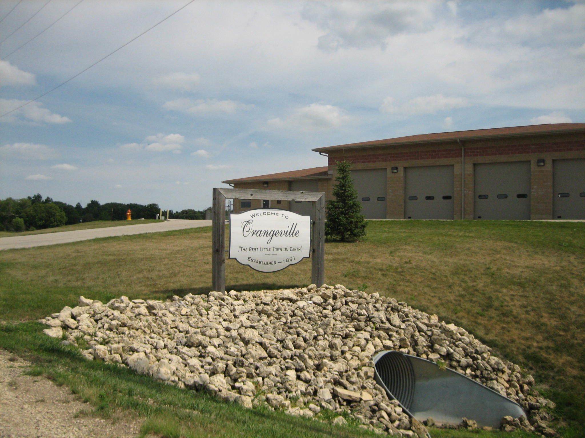
Orangeville Village 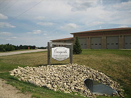 Sign upon entering the village of Orangeville.
Motto: The best little town on earth. Country United States State Illinois County Stephenson Township Oneco Elevation 820 ft (250 m) Coordinates 42°28′01″N 89°38′46″W / 42.46694°N 89.64611°W Area 0.6 sq mi (2 km2) - land 0.6 sq mi (2 km2) - water 0.0 sq mi (0 km2) Population 793 (2010) Density 1,168.9 / sq mi (451 / km2) Founded 1851 Village President Donald Hoyle Postal code 61060 Area code 815 
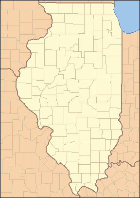
 Location of Orangeville within Illinois
Wikimedia Commons: Orangeville, Illinois Orangeville is a village in Stephenson County, Illinois, United States. The population was 793 at the 2010 census, up from 751 at the 2000 census. The area's earliest white settlers arrived in 1833 and the village was platted in 1851 by John Bower, who is considered the village founder. In 1867 Orangeville was incorporated as a village. The town's central business district contains several 19th century commercial buildings many of which were built during the railroad boom of between 1888–1914. By the time the Great Depression was ongoing, business in Orangeville had started to decline, with the last bank closing in 1932.
Orangeville is about two miles (3 km) south of the Illinois–Wisconsin border and about 35 miles (56 km) west of Rockford, Illinois. The town itself is located in farmland surrounded vale and rises from the Richland Creek on its west end, down High Street and into the central business district, where the Central House hotel occupies the highest lot. Public education in Orangeville is the responsibility of Orangeville Community School District #203 which operates an elementary school and a combination junior and senior high school.
Contents
History
Early history
Before 1837 the area was occupied by Native Americans who utilized it for hunting grounds; the Sioux tribe had a camp near Oneco. Game that populated the Orangeville area included buffalo and deer.[1] John H. Curtis purchased the 80 acres (32 ha) of land, which included the area that would eventually become Orangeville, on January 1, 1838 at the Dixon Land Office. Curtis constructed a dam on Richland Creek, and on the creek's west bank erected a gristmill and a saw mill. Curtis died in 1843 and both mills stood idle until John Bower arrived in 1846, with his family, after having visited the area the year before. Bower purchased the 80 acres (32 ha) and the mills.[2]
Throughout the 1830s and 1840s farmers from New York and Pennsylvania, known as the Pennsylvania Dutch, arrived to settle the area around present-day Orangeville. Of the first 14 settlers to the area, 13 were Pennsylvania Dutch, the 14th was a German immigrant. A Dr. Thomas Van Valsah led a wagon train from Pennsylvania to Stephenson County in 1837.[2]
The village of Orangeville was founded by John Bower, popularly confused as "Bowers." Bower came to Stephenson County in 1845 and, on October 16, 1846, bought the land that would be platted as Orangeville from for $950. Bower built the Union House in 1849 on a portion of what became Orangeville in 1851.[3] Though the town was platted by Bower in 1851, it was not incorporated until 1867.[2] A drawing of the plat was done by surveyor Marcus Montelius and indicated that Orangeville has always been known as Orangeville; several publications have asserted that the town began as Bowersville or Bowers Mills and underwent a name change in 1854.[4] It is possible that the incorrect name Bowersville was a misremembered version of "Bower's mill".[1] The plat also showed 48 original town lots.[4]
At the outset, Bower brought "wagon loads" of lumber from Galena and Chicago to the settlement, and by 1849 he had reconstructed and improved the gristmill. The mill was completed in 1850 at a cost of $8,000. Charles Moore, who would become the first President of the village when it was incorporated, came to the town, lured by Bower's efforts, in 1849. George Hamilton built a store and soon farmers began to build houses, by 1850 a stagecoach served the area. In September 1852 construction began on Orangeville's first church.[4]
By 1854 Orangeville was in competition with the village of Oneco as a growing center of commerce. That year, the federal government decided that population growth in the two villages warranted the establishment of a post office. On an appointed day, residents of both villages lined up on the sides of the street according to which town they supported as the location for the post office. Orangeville won by a narrow margin.[2]
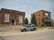
 The current Orangeville post office; in 1854 the village narrowly won an election over Oneco for post office location.
Arrival of the railroad
After its incorporation the village continued to prosper, the downtown district was mostly complete by the 1870s, with all commercial lots purchased and improved. Mel Trotter who established a chain of rescue missions during his lifetime, was born in the village on May 16, 1870 and lived there until he was five years old when his family moved to Polo, Illinois.[5] By 1877, the village population was up to 300 and in 1883 the Orangeville Alert, the first village newspaper, was established. In 1887, the Illinois Central Railroad decided to link Freeport to Madison, Wisconsin. The only incorporated village along that line was Orangeville, the railroad came in 1888 and led to commercial building boom.[6] This building boom directly resulted in 14 new buildings being erected downtown, all brick buildings downtown save the 1906 Wagner Building and the 1899 R.W. Moore Building were a result of the railroad. Between 1888 and 1914 numerous business developed along the corridor of Main and High Streets, those included: restaurants, drug stores, barber shops, banks, watch and clock repair shops, cigar factory, funeral parlor and casket factory, among several others.[6]
Great Depression
In 1928, just before the onset of the Great Depression, Illinois State Highway 74 (later Illinois Route 26) was rerouted through the eastern part of Orangeville, bypassing the downtown business district. Though the downtown district no longer had a major thoroughfare passing through it, many of the business were able to survive, at least initially. By 1928 the decline in the business community of Orangeville was evident; the bypass, coupled with the depression continued to negatively affect the village. In 1932 the People's State Bank, the last open bank in Orangeville, closed its doors.[6]
Geography
Orangeville is located at 42°28′1″N 89°38′46″W / 42.46694°N 89.64611°W (42.466900, -89.646003)[7]. According to the United States Census Bureau, the village has a total area of 0.6 square miles (1.6 km2), all of it land. The village of Orangeville is located in northern Stephenson County, Illinois, about two miles (3 km) south of the Illinois-Wisconsin border. The village is 11 miles (18 km) south of Monroe, Wisconsin, 12 miles (19 km) north of Freeport, Illinois, 35 miles (56 km) west of Rockford, Illinois and 60 miles (97 km) east of Dubuque, Iowa.[4]
The village is located in a vale which is surrounded by farmland. At the western end, and lowest end, of town Richland Creek runs north–south and is paralleled by the old Illinois Central Railroad bed. The railroad bed is now part of the Jane Addams Trail. High Street, which runs through the historic downtown is the primary east–west route through the village and Main Street, which intersects High Street at its highest point, becomes Freeport Road and leads to the city of Freeport.[6]
Cityscape
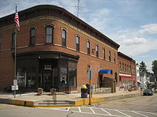
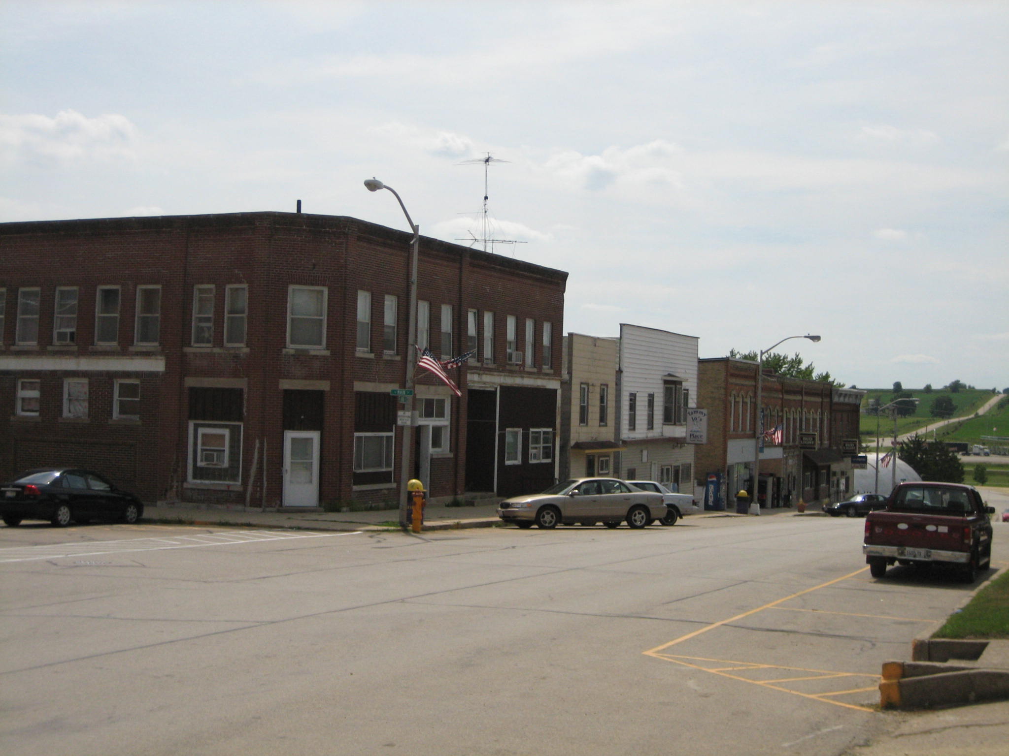
 The Central House hotel and the People's State Bank were the first and last commercial buildings built in downtown Orangeville.
The central business district is along High and Main Streets, and forms downtown Orangeville. High Street slopes uphill from the Richland Creek and is populated by historic, 19th century buildings.[6] At the summit of High Street's slope is the Central House, which is listed on the U.S. National Register of Historic Places.[3][6][8] In total, four of the five structures on the National Register in Orangeville, are found along High Street; the Union House and the Orangeville Masonic Hall are the other two.[8] Other historic buildings in the approximately three block area include the 1888 Musser Building, and the 1906 Wagner Building.[6]
The first commercial brick building to be constructed in the main business district was the Central House, which operated as a hotel from its construction during the 1860s until its conversion to a single family residence in the 1930s. All other buildings were erected around Central House, which was specifically located and designed to be the center piece of downtown Orangeville.[4] The People's State Bank was the last major commercial building constructed in historic downtown Orangeville.[6]
Culture
Social and fraternal organizations
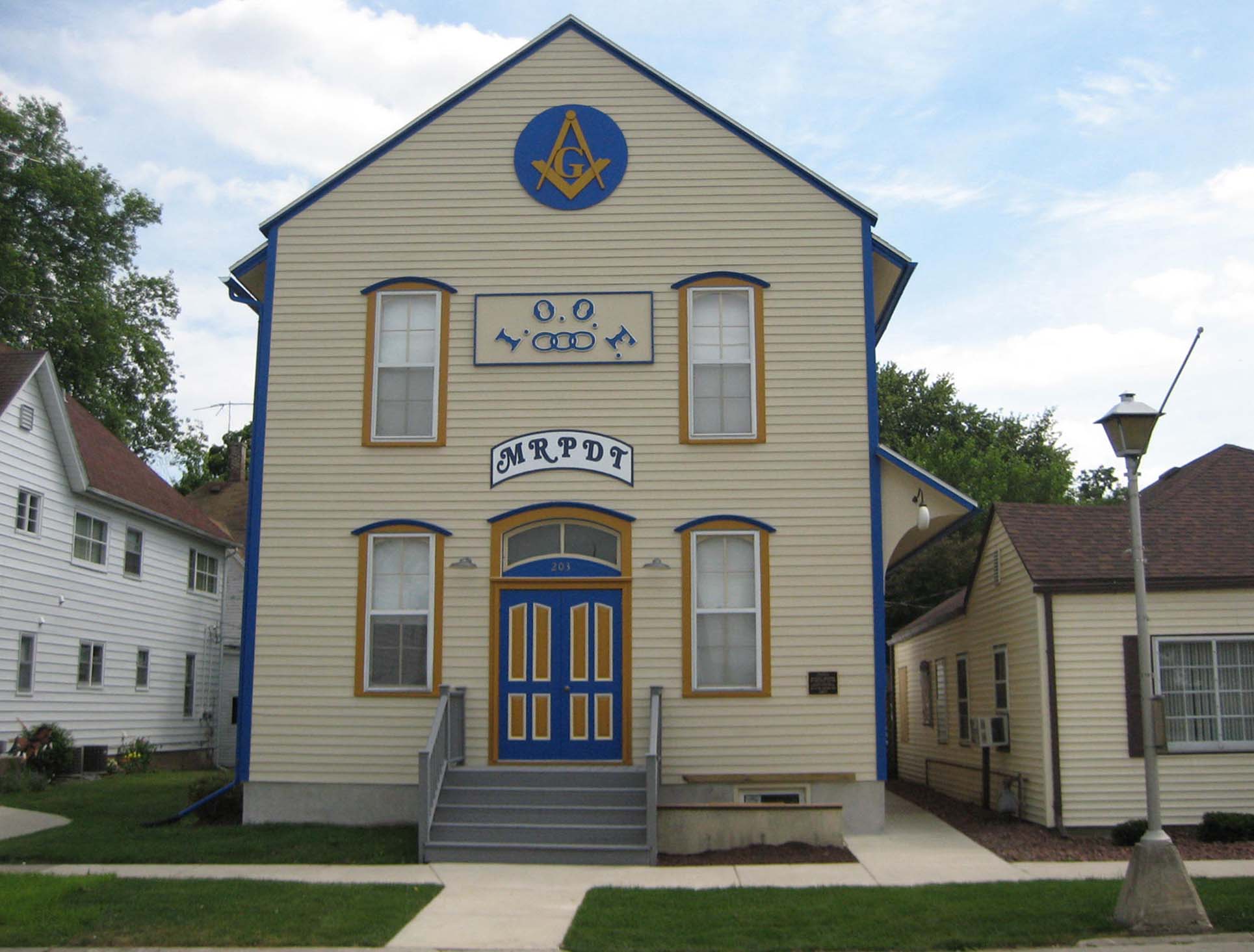
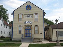 The Orangeville Masonic Lodge was built by the AF and AM in 1876, but is used by all of Orangeville's fraternal organizations.
Social and fraternal organizations have played a major role in the community and the social history of Orangeville.[2] There have been several organizations in Orangeville throughout its history and in 1876 the local Ancient Free and Accepted Masons (AF and AM) Lodge erected the Orangeville Masonic Hall. Though the building was originally constructed to serve as the meeting hall for the local AF and AM Lodge, from its opening it has always been used by all of Orangeville's fraternal organizations.[2]
The Orangeville AF and AM Lodge 687 was chartered October 1, 1872 and its sister organization, Eastern Star, Willow Chapter #434 was founded in 1899. The group held its meetings on the second floor of the Masonic Hall and the first floor was reserved for entertainment and social functions. The Lodge is still active in Orangeville today. The Orangeville Independent Order of Odd Fellows, (IOOF) J.R. Scruggs Lodge 372 was formed on October 18, 1868. The Orangeville IOOF Lodge assisted the March 10, 1896 establishment of their sister organization, the Rebekah Lodge. The IOOF has faced dwindling membership and, in 2002, the Orangeville chapter had less than 50 members.[2]
Orangeville Lodge No. 133 of the International Organization of Good Templars was established in 1867, as a temperance lodge, but it soon dissolved. Other short-lived lodges include the Grand Army of the Republic Lodge, Modern Woodmen of America, and various other temperance lodges. Regardless of their longevity, each of these groups met in the same Orangeville Masonic Hall.[2]
Demographics
As of the census[9] of 2000, there were 751 people, 297 households, and 209 families residing in the village. The population density was 1,168.9 people per square mile (453.1/km²). There were 316 housing units at an average density of 491.8 per square mile (190.6/km²). The racial makeup of the village was 99.60% White, 0.13% African American, and 0.27% from two or more races. Hispanic or Latino of any race were 0.93% of the population.
 Buildings in downtown Orangeville, Illinois.
There were 297 households out of which 39.7% had children under the age of 18 living with them, 58.6% were married couples living together, 9.8% had a female householder with no husband present, and 29.6% were non-families. 27.6% of all households were made up of individuals and 11.4% had someone living alone who was 65 years of age or older. The average household size was 2.53 and the average family size was 3.10.
In the village the population was spread out with 30.9% under the age of 18, 5.6% from 18 to 24, 31.2% from 25 to 44, 20.9% from 45 to 64, and 11.5% who were 65 years of age or older. The median age was 34 years. For every 100 females there were 101.3 males. For every 100 females age 18 and over, there were 93.7 males.
The median income for a household in the village was $39,875, and the median income for a family was $45,000. Males had a median income of $30,670 versus $23,646 for females. The per capita income for the village was $17,437. About 1.4% of families and 3.3% of the population were below the poverty line, including 3.8% of those under age 18 and 5.1% of those age 65 or over.
Education
Public education in Orangeville is provided by Orangeville Community School District #203. The district operates an elementary school, Orangeville Elementary School, and a one-building junior and senior high school, Orangeville Jr/Sr High School.[10][11] The high school team mascots are the Broncos.[10] The district is administrated by a seven member Board of Education, which includes three officers, a president, a vice president, and a secretary.[12]
See also
- Central House
- Charles Fehr Round Barn
- People's State Bank
- Orangeville Masonic Hall
- William Ritzman House
Notes
- ^ a b "Orangeville, Illinois," Trail History: Communities, Jane Addams Trail, official site. Retrieved October 10, 2007.
- ^ a b c d e f g h Buford, John C. (December, 2002). "National Register of Historic Places Registration: AF and AM Lodge 687 / IOOF J.R. Scruggs Lodge 372". Illinois Historic Preservation Agency. http://gis.hpa.state.il.us/hargis/PDFs/114796.pdf. Retrieved 2007-10-09 and 2011-01-11.
- ^ a b Buford, John C. "Union House," (PDF), National Register of Historic Places Nomination Form, November 29, 1999, HAARGIS Database, Illinois Historic Preservation Agency. Retrieved October 9, 2007.
- ^ a b c d e Buford, John C. "Central House," (PDF), National Register of Historic Places Nomination Form, December 16, 1998, HAARGIS Database, Illinois Historic Preservation Agency. Retrieved October 9, 2007.
- ^ Hertel, Leona. Man with a Mission: Mel Trotter and His Legacy for the Rescue Mission Movement, (Google Books), Kregel Publications: 2000, p. 15, (ISBN 0825427991). Retrieved October 9, 2007.
- ^ a b c d e f g h Buford, John C. "People's State Bank," (PDF), National Register of Historic Places Nomination Form, February 26, 2004, HAARGIS Database, Illinois Historic Preservation Agency. Retrieved October 9, 2007.
- ^ "US Gazetteer files: 2010, 2000, and 1990". United States Census Bureau. 2011-02-12. http://www.census.gov/geo/www/gazetteer/gazette.html. Retrieved 2011-04-23.
- ^ a b National Register Information System[dead link], National Register of Historic Places, National Park Service. Retrieved October 9, 2007.
- ^ "American FactFinder". United States Census Bureau. http://factfinder.census.gov. Retrieved 2008-01-31.
- ^ a b "Orangeville Jr/Sr High School," Orangeville Community School District #203, official site. Retrieved October 9, 2007.
- ^ "Orangeville Community School District #203," home page; official site. Retrieved October 9, 2007.
- ^ "Administrative Information, Orangeville Community School District #203, official site. Retrieved October 9, 2007.
Municipalities and communities of Stephenson County, Illinois County seat: Freeport City 
Villages Cedarville | Dakota | Davis | German Valley | Lena | Orangeville | Pearl City | Ridott | Rock City | Winslow
CDP Townships Unincorporated
communitiesFootnotes ‡This populated place also has portions in an adjacent county or counties
Categories:- NRHP articles with dead external links
- Orangeville, Illinois
- Villages in Illinois
- Populated places established in 1851


Wikimedia Foundation. 2010.