- McFarland, California
-
City of McFarland — City — Location in Kern County and the state of California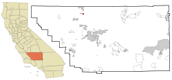
Coordinates: 35°40′41″N 119°13′45″W / 35.67806°N 119.22917°WCoordinates: 35°40′41″N 119°13′45″W / 35.67806°N 119.22917°W Country  United States
State  California
County Kern Government - Senate Dean Florez (D) - Assembly Danny Gilmore (R) - U. S. Congress Jim Costa (D) Area[1] - Total 2.668 sq mi (6.910 km2) - Land 2.668 sq mi (6.910 km2) - Water 0 sq mi (0 km2) 0% Elevation[2] 354 ft (108 m) Population (2010) - Total 12,707 - Density 4,762.7/sq mi (1,838.9/km2) Time zone PST (UTC-8) - Summer (DST) PDT (UTC-7) ZIP code 93250 Area code(s) 661 FIPS code 06-44826 GNIS feature ID 1652750 McFarland (formerly, Hunt and Lone Pine)[3] is a city in the San Joaquin Valley, in Kern County, California, United States. McFarland is located 6.5 miles (10 km) south of Delano,[3] at an elevation of 354 feet (108 m).[2] The population was 12,707 at the 2010 census, up from 9,618 at the 2000 census.
Contents
History
The first post office opened in 1908.[3] McFarland incorporated in 1957.[3] The name honors J.B. McFarland, founder.[3]
Demographics
2010
The 2010 United States Census[4] reported that McFarland had a population of 12,707. The population density was 4,762.7 people per square mile (1,838.9/km²). The racial makeup of McFarland was 5,433 (42.8%) White, 236 (1.9%) African American, 171 (1.3%) Native American, 84 (0.7%) Asian, 6 (0.0%) Pacific Islander, 6,330 (49.8%) from other races, and 447 (3.5%) from two or more races. Hispanic or Latino of any race were 11,625 persons (91.5%).
The Census reported that 11,486 people (90.4% of the population) lived in households, 27 (0.2%) lived in non-institutionalized group quarters, and 1,194 (9.4%) were institutionalized.
There were 2,599 households, out of which 1,818 (69.9%) had children under the age of 18 living in them, 1,663 (64.0%) were opposite-sex married couples living together, 456 (17.5%) had a female householder with no husband present, 246 (9.5%) had a male householder with no wife present. There were 189 (7.3%) unmarried opposite-sex partnerships, and 14 (0.5%) same-sex married couples or partnerships. 170 households (6.5%) were made up of individuals and 71 (2.7%) had someone living alone who was 65 years of age or older. The average household size was 4.42. There were 2,365 families (91.0% of all households); the average family size was 4.51.
The population was spread out with 4,468 people (35.2%) under the age of 18, 1,700 people (13.4%) aged 18 to 24, 4,030 people (31.7%) aged 25 to 44, 1,925 people (15.1%) aged 45 to 64, and 584 people (4.6%) who were 65 years of age or older. The median age was 25.7 years. For every 100 females there were 128.3 males. For every 100 females age 18 and over, there were 142.4 males.
There were 2,683 housing units at an average density of 1,005.6 per square mile (388.3/km²), of which 1,488 (57.3%) were owner-occupied, and 1,111 (42.7%) were occupied by renters. The homeowner vacancy rate was 0.9%; the rental vacancy rate was 2.6%. 6,519 people (51.3% of the population) lived in owner-occupied housing units and 4,967 people (39.1%) lived in rental housing units.
2009
- Hispanic (95.7%)
- Other race (4.3%)
- White Non-Hispanic (3.2%)
- Two or more races (4.7%)
- Black (3.3%)
(Total can be greater than 100% because Hispanics could be counted in other races)
2000
As of the census[6] of 2000, there were 9,618 people, 1,990 households, and 1,789 families residing in the city. The population density was 4,671.8 people per square mile (1,802.7/km²). There were 2,031 housing units at an average density of 986.5 per square mile (380.7/km²). The racial makeup of the city was 28.49% White, 3.19% Black or African American, 1.63% Native American, 0.69% Asian, 0.08% Pacific Islander, 61.23% from other races, and 4.69% from two or more races. 85.66% of the population were Hispanic or Latino of any race.
There were 1,990 households out of which 61.7% had children under the age of 18 living with them, 64.4% were married couples living together, 17.3% had a female householder with no husband present, and 10.1% were non-families. 7.7% of all households were made up of individuals and 4.7% had someone living alone who was 65 years of age or older. The average household size was 4.30 and the average family size was 4.45.
In the city the population was spread out with 35.1% under the age of 18, 14.1% from 18 to 24, 33.1% from 25 to 44, 12.8% from 45 to 64, and 4.8% who were 65 years of age or older. The median age was 25 years. For every 100 females there were 132.2 males. For every 100 females age 18 and over, there were 151.5 males.
The median income for a household in the city was $12,821, and the median income for a family was $14,190. Males had a median income of $19,881 versus $9,109 for females. The per capita income for the city was $9,524. About 34.1% of families and 35.2% of the population were below the poverty line, including 41.1% of those under age 18 and 12.1% of those age 65 or over.
Notable locations
- Jackson Branch Kern County Library
- McFarland City Hall
- Maria's Pizza
- Palace Market
- Country Burgers
Churches
- Saint Elizabeth Catholic Church
- El Buen Pastor Church
- Iglesia Ni Cristo
- Jehovah's Witnesses
- Church of the Living Savior
Media
AM radio stations
- KERI (1180 AM; 50 kW; WASCO-GREENACRES, CA; Owner: KWSO, INC.)
- KCHJ (1010 AM; 5 kW; DELANO, CA; Owner: ILLINOIS LOTUS CORP.)
- KNZR (1560 AM; 25 kW; BAKERSFIELD, CA; Owner: BUCKLEY BROADCASTING CORP. OF CALIF.)
- KMJ (580 AM; 50 kW; FRESNO, CA; Owner: INFINITY RADIO OPERATIONS INC.)
- KWRU (940 AM; 50 kW; FRESNO, CA)
- KUZZ (550 AM; 5 kW; BAKERSFIELD, CA; Owner: OWENS ONE COMPANY)
- KGET (970 AM; 5 kW; BAKERSFIELD, CA; Owner: CLEVELAND RADIO LICENSES, LLC)
- KGDP (660 AM; 50 kW; ORCUTT, CA; Owner: RADIO REPRESENTATIVES, INC.)
- KAFY (1100 AM; 4 kW; BAKERSFIELD, CA; Owner: KAFY, INC.)
- KIRN (670 AM; 35 kW; SIMI VALLEY, CA; Owner: LOTUS OXNARD CORP.)
- KSPN (710 AM; 50 kW; LOS ANGELES, CA; Owner: KABC-AM RADIO, INC.)
- KLAC (570 AM; 50 kW; LOS ANGELES, CA; Owner: AMFM RADIO LICENSES, L.L.C.)
- KMAP (1050 AM; 10 kW; FRAZIER PARK, CA; Owner: KMAP, INC.)
FM radio stations
- K266AH (101.1 FM; BENA, CA; Owner: CALVARY CHAPEL OF TWIN FALLS, INC.)
- KTQX (90.1 FM; BAKERSFIELD, CA; Owner: RADIO BILINGUE, INC.)
- KZPO (103.3 FM; LINDSAY, CA; Owner: LINDSAY BROADCASTING)
- KMQA (100.5 FM; EAST PORTERVILLE, CA; Owner: MOON BROADCASTING PORTERVILLE L.L.C.)
- KKBB (99.3 FM; BAKERSFIELD, CA; Owner: BUCKLEY COMMUNICATIONS, INC.)
- KDUV (88.9 FM; VISALIA, CA; Owner: COMMUNITY EDUCATIONAL B/CASTNG, INC.)
- KDFO-FM (98.5 FM; DELANO, CA; Owner: CLEAR CHANNEL BROADCASTING LICENSES, INC.)
- KKDJ (105.3 FM; DELANO, CA; Owner: CLEAR CHANNEL BROADCASTING LICENSES, INC.)
- K293AG (106.5 FM; TAFT, CA; Owner: CENTRO CRISTIANO DE FE, INC.)
- KJUG-FM (106.7 FM; TULARE, CA; Owner: WESTCOAST BROADCASTING, INC.)
- K220EY (91.9 FM; PORTERVILLE, CA; Owner: FAMILY STATIONS, INC.)
- KIWI (102.9 FM; MCFARLAND, CA; Owner: ILLINOIS LOTUS CORP.)
- KUFW (90.5 FM; WOODLAKE, CA; Owner: NATIONAL FARM WORKERS SERVICE CENTER)
- KMYX-FM (92.5 FM; ARVIN, CA; Owner: FARMWORKER EDUC. RADIO NETWORK, INC.)
- KGZO (90.9 FM; SHAFTER, CA; Owner: THE ASSOCIATION FOR COMMUNITY EDUCATION, INC.)
- KFRB (91.3 FM; BAKERSFIELD, CA; Owner: FAMILY STATIONS, INC.)
- KUZZ-FM (107.9 FM; BAKERSFIELD, CA; Owner: OWENS ONE COMPANY, INC)
- KISV (94.1 FM; BAKERSFIELD, CA; Owner: AMERICAN GENERAL MEDIA CORP.)
- KGFM (101.5 FM; BAKERSFIELD, CA; Owner: LAGNIAPPE BROADCASTING, INC.)
- KSMJ (97.7 FM; SHAFTER, CA; Owner: BUCKLEY BROADCASTING CORPORATION OF CALIFORNIA)
TV broadcast stations
- KTRO-LP (Channel 50; LANCASTER, CA; Owner: ROBERT D. ADELMAN)
- KPMC-LP (Channel 42; BAKERSFIELD, CA; Owner: GARY M. COCOLA FAMILY TRUST)
References
- ^ U.S. Census
- ^ a b U.S. Geological Survey Geographic Names Information System: McFarland, California
- ^ a b c d e Durham, David L. (1998). California's Geographic Names: A Gazetteer of Historic and Modern Names of the State. Quill Driver Books. p. 1069-1070. ISBN 9781884995149.
- ^ All data are derived from the United States Census Bureau reports from the 2010 United States Census, and are accessible on-line here. The data on unmarried partnerships and same-sex married couples are from the Census report DEC_10_SF1_PCT15. All other housing and population data are from Census report DEC_10_DP_DPDP1. Both reports are viewable online or downloadable in a zip file containing a comma-delimited data file. The area data, from which densities are calculated, are available on-line here. Percentage totals may not add to 100% due to rounding. The Census Bureau defines families as a household containing one or more people related to the householder by birth, opposite-sex marriage, or adoption. People living in group quarters are tabulated by the Census Bureau as neither owners nor renters. For further details, see the text files accompanying the data files containing the Census reports mentioned above.
- ^ a b "City-data - McFarland-California". analyzed data from numerous sources. http://www.city-data.com/city/McFarland-California.html. Retrieved 2009-03-17.
- ^ "American FactFinder". United States Census Bureau. http://factfinder.census.gov. Retrieved 2008-01-31.
Municipalities and communities of Kern County, California County seat: Bakersfield Cities Arvin | Bakersfield | California City | Delano | Maricopa | McFarland | Ridgecrest | Shafter | Taft | Tehachapi | Wasco
CDPs Bear Valley Springs | Bodfish | Boron | Buttonwillow | Cherokee Strip | China Lake Acres | Derby Acres | Dustin Acres | Edmundson Acres | Edwards Air Force Base | Fellows | Ford City | Frazier Park | Fuller Acres | Golden Hills | Greenacres | Greenfield | Inyokern | Johannesburg | Keene | Kernville | Lake Isabella | Lake of the Woods | Lamont | Lebec | Lost Hills | McKittrick | Mettler | Mexican Colony | Mojave | Mountain Mesa | North Edwards | Oildale | Onyx | Pine Mountain Club | Randsburg | Rosamond | Rosedale | Smith Corner | South Taft | Squirrel Mountain Valley | Stallion Springs | Taft Heights | Tupman | Valley Acres | Weedpatch | Weldon | Wofford Heights
Unincorporated
communitiesActis | Aerial Acres | Alameda | Algoso | Alta Sierra | Annette | Ansel | Armistead | Baker | Bannister | Bealville | Bena | Bissell | Blackwells Corner | Bowerbank | Bradys | Brown | Burton Mill | Cable | Calders Corner | Calico | Caliente | Cameron | Camp Owens | Canebrake | Cantil | Cawelo | Ceneda | Chaffee | China Lake | Cinco | Claraville | Conner | Crome | Desert Lake | Di Giorgio | Dow | East Bakersfield | Edison | Edwards | El Rita | Elmo | Famoso | Fig Orchard | Five Points | Fleta | Fruitvale | Glennville | Goler Heights | Gosford | Grapevine | Gulf | Gypsite | Halfway House | Harpertown | Harts Place | Havilah | Hazelton | Hights Corner | Hollis | Ilmon | Indian Wells | Jasmin | Jastro | Kayandee | Kecks Corner | Kern Lake | Kernell | Keyesville | Kilowatt | Lackey Place | Lakeview | Landco | Lerdo | Lokern | Lonsmith | Loraine | Magunden | Maltha | Manolith | Marcel | Mayfair | Meridian | Midoil | Millersville | Millux | Minter Village | Miracle Hot Springs | Missouri Triangle | Mitchells Corner | Monolith | Moreland Mill | Myricks Corner | Neufeld | North Belridge | North Shafter | Oil City | Oil Junction | Old Garlock | Old River | Old Town | Palmo | Panama | Patch | Pentland | Pettit Place | Pinon Pines Estates | Pond | Prospero | Pumpkin Center | Quality | Rancho Seco | Rand | Reward | Ribier | Ricardo | Rich | Rio Bravo | Riverkern | Rowen | Saco | Sageland | Saltdale | San Emidio | Sanborn | Sand Canyon | Searles | Seguro | Semitropic | Shirley Meadows | Silt | Slater | South Lake | Spellacy | Spicer City | Stevens | Summit | Thomas Lane | Twin Lakes | Twin Oaks | Una | Venola | Vinland | Walker Basin | Wallace Center | Walong | Wheeler Ridge | Wible Orchard | Willow Springs | Woodford | Woody | Zentner
Former
settlements18 Mile House | Allard | Amalie | Artwell | Asphalto | Barnes Settlement | Benita | Big Blue Mill | Borel | Burkeville | Cabernet | Cambio | Canebrake | Canfield | Chanz | Clarkson | Code | Craft | Cuttens | Desert Spring | Domino | Eaires | Eric | Fluhr | Fram | Gamba | Garlock | Girard | Glenburn | Gold Town | Greenwich | Gyle | Indian Springs | Inmans | Isabella | Joe Walker Town | Joyfull | Kern River Slough | Kernvale | Kernville | Kyan | La Rose | Langdon | Lavers' Crossing | Leliter | Leonards | Levee | Levee Spur | Little Dixie | Martendale | Midway | Miramonte | Monterio | Moseman | Muroc | Nadeau | Neil | Neuralia | Nome | North Muroc | Olig | Packwood | Page | Paloma | Parsons | Petersburg | Petro | Pine | Piute | Proctor | Progress | Pylema | Quartzburg | Redrock | Reefer City | Reservoir | Rio Bravo | Riverview | Rock Springs | Rogersville | Sage | San Miguel de los Noches | Sand Cut | Scovern Hot Springs | Sedwell | Shady Rest | Shale | Shamrock | Smyrna | Solon | Sorrell's | Strader | Strand | Sullivan | Summers | Sunset | Teagle | Tehichipa | Tejon | Terese | Terese Siding | Toolwass | Trescape | Treves | Una Siding | Unadilla | Vaccaro | Vaughn | Vernette | Warren (Fellows) | Warren (Mojave) | Water Station | West Baker | Winter Garden
Categories:- Cities in Kern County, California
- 1957 establishments
- Incorporated cities and towns in California
- San Joaquin Valley
- Populated places in California with Hispanic majority populations


Wikimedia Foundation. 2010.