- PATH (Toronto)
-
PATH 
Location Toronto, Ontario, Canada Opening date 1900 - first pedestrian tunnel in Toronto
1960-70s - construction begins of underground shopping concourses and linkages
1987 - City becomes coordinating agency of networkManagement City of Toronto
(co-ordinating agency)No. of stores and services 1,200 Total retail floor area 371,600 m²
(4 million sq. ft)Parking 20 parking garages No. of floors 1 Website www.toronto.ca/path/ PATH is a 28-kilometre (17 mi) network of pedestrian tunnels beneath the office towers of Downtown Toronto, Ontario, Canada. According to Guinness World Records, PATH is the largest underground shopping complex in the world with 371,600 m² (4 million sq. ft.) of retail space.[1]
The PATH network's northerly point is the Toronto Coach Terminal at Dundas Street and Bay Street, while its southerly point is the Metro Toronto Convention Centre's Convention South Building. Its main axes of walkways generally parallel Yonge Street and Bay Street.
Contents
Early pedestrian tunnels
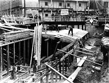 The first tunnel under construction in 1900 for Eaton's
In 1900, the Eaton's department store constructed a tunnel underneath James Street, allowing shoppers to walk between the Eaton's main store at Yonge and Queen streets and the Eaton's Annex located behind the (then) City Hall. It was the first underground pedestrian pathway in Toronto, and is often credited as a historic precursor to the current PATH network. The original Eaton's tunnel is still in use as part of the PATH system, although today it connects the Toronto Eaton Centre to the Bell Trinity Square office complex (the latter of which stands on the site of the former Annex building).
Another original underground linkage, built in 1927 to connect Union Station and the Royal York Hotel, also remains an integral part of today's PATH network.
Origins of current system
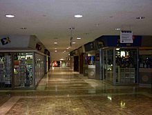 An underground shopping area in the financial district. (The PATH signage is shown hanging from the ceiling on the upper right side of the photo)
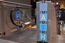 Entrance to PATH
The current PATH system began under city planner Matthew Lawson in the 1960s. Toronto's downtown sidewalks were overcrowded, and new office towers were removing the much-needed small businesses from the streets. Lawson thus convinced several important developers to construct underground malls, pledging that they would eventually be linked. The designers of the Toronto-Dominion Centre, the first of Toronto's major urban developments in the 1960s and completed in 1967, were the first to include underground shopping in their complex, with the possibility of future expansion built in. The city originally helped fund the construction, but with the election of a reform city council this ended. The reformers disliked the underground system based on the Jane Jacobs notion that an active street life was important to keeping cities and neighbourhoods vital and that consumers should be encouraged to shop on street level stores rather than in malls (whether they be above ground or below); however, the system continued to grow, as developers bowed to their tenants' wishes and connected their buildings to the system. This also converted low-valued basements into some of the most valuable retail space in the country.
The first expansion of the network occurred in the 1970s with the construction and underground connection of the Richmond-Adelaide office tower and the Sheraton Centre hotel complex.
Path signage
In 1987, City Council adopted a unified wayfinding system throughout the network. The design firms Gottschalk+Ash International and Muller Design Associates were hired to design and implement the overall system in consultation with a diverse group of land owners, City staff and stakeholders. A colour-coded system with directional cues was deployed in the early 1990s. Within the various buildings, pedestrians can find a PATH system map, plus cardinal directions (P (red) for south, A (orange) for west, T (blue) for north, H (yellow) for east) on ceiling signs at selected junctions.
The signage can be hard to find inside some of the various connected buildings. Building owners concerned about losing customers to neighbouring buildings insisted that the signs not dominate their buildings, or their own signage system. The city relented and the result is the current system. Many complain that the system is hard to navigate.[2]
Future expansion
The City of Toronto released a long-term expansion plan for the PATH. As part of the expansion plan there will be 45 new entry points, and the walkway expanded to as long as 60 kilometres when changes are completed. [3] The city of Toronto is constructing a 300-metre, $65 million (EUR 50 million US$65.8 million) tunnel connecting Union Station to Wellington Street, the first publicly-owned segment of the 4,000,000-square-foot (370,000 m2) PATH subterranean shopping district. Toronto planners have begun work to guide future PATH development and ensure PATH link construction is included in basement levels of key new buildings.[4]
Major facilities connected to PATH
There are more than 50 buildings or office towers that are connected through the PATH system. It comprises twenty parking garages, five subway stations (Osgoode station connects only to the Four Seasons Centre), two major department stores, two major shopping centres, six major hotels, and a railway terminal. The CN Tower and Rogers Centre are connected via an enclosed elevated walkway, called Skywalk, from Union Station.
- 1 King Street West
- 2 Queen Street East
- 22 Front Street West
- 55 University (Markel building)
- 150 York
- Air Canada Centre
- Atrium on Bay
- Bay Adelaide Centre
- Bell Trinity Square
- Brookfield Place
- Canadian Broadcasting Centre
- Citibank Place
- City Hall
- Commerce Court
- Design Exchange
- Dundas Square
- Dundee Place
- Exchange Tower
- Federal Building
- First Canadian Place
- Four Seasons Centre*
- Hilton Hotel
- Hockey Hall of Fame
- HSBC Bank of Canada Building
- Hudson's Bay Company's The Bay Queen Street
- ING Tower
- MetLife Place
- Metro Hall
- Metro Toronto Convention Centre
- Munich Re Centre
- Richmond Adelaide Complex
- RBC Centre
- Roy Thomson Hall
- Royal Bank Plaza
- Royal York Hotel
- Ryerson University
- Scotia Plaza
- Sheraton Centre
- Sun Life Centre
- Telus Tower
- 10 Dundas East
- Thomson Building
- Toronto-Dominion Centre
- Toronto Eaton Centre
- Toronto Coach Terminal
- TTC subway stations:
- Union Station
- Victory Building
- Yonge-Richmond Centre
See also
References
- ^ City of Toronto - PATH facts
- ^ Lakey, Jack (August 26, 2009). "For Some Visitors, It's a PATH That Leads Nowhere". Toronto Star. http://www.thestar.com/news/gta/fixer/article/686543--for-some-visitors-it-s-a-path-that-leads-nowhere. Retrieved August 6, 2011.
- ^ Marcus, S: "The Ryersonian", page 1, 5. Ryerson University School of Journalism, September 26, 2007
- ^ Kryhul, Angela (June 29, 2010). "Toronto Shines a Light on Underground PATH". The Globe and Mail (Toronto). http://www.theglobeandmail.com/report-on-business/toronto-shines-a-light-on-underground-path/article1622826/. Retrieved August 6, 2011.
External links
List of shopping malls in Toronto and the Golden Horseshoe City of Toronto Atrium on Bay • Bayview Village • Cedarbrae Mall • Centerpoint Mall • College Park • The Crossways • Dufferin Mall • Toronto Eaton Centre • Eglinton Square • Empress Walk • Fairview Mall • Hazelton Lanes • Honeydale Mall • Landmark* • Lawrence Plaza • Lawrence Square • Manulife Centre • Parkway Mall • PATH • Queen's Quay Terminal • Scarborough Town Centre • Sherway Gardens • Shoppers World Danforth • Shops at Don Mills • Splendid China Tower* • Woodbine Centre • YorkdalePeel Region York Region Hillcrest Mall • Market Village* • Markville Shopping Centre • Pacific Mall* • The Promenade • Upper Canada Mall • Vaughan MillsDurham Region Halton Region City of Hamilton Niagara Region Simcoe County Waterloo Region Wellington County The largest mall in each area is bolded. *Ethnic mallsCategories:- Shopping malls in Toronto
- Pedways in Canada
- Underground cities
- PATH (Toronto)


Wikimedia Foundation. 2010.