- May 1957 Central Plains tornado outbreak
-
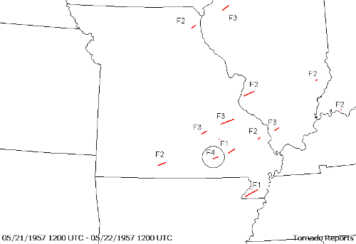
May 1957 Central Plains tornado outbreak Map of tornadoes on May 21, 1957.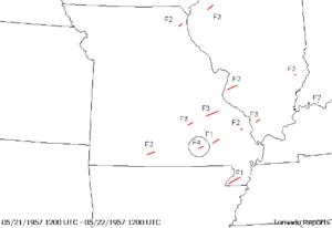
Date of tornado outbreak: May 19-May 21, 1957 Duration1: 3 days Maximum rated tornado2: F5 tornado Tornadoes caused: 57 confirmed Damages: Not yet available Fatalities: 59 Areas affected: Central US Plains and Mississippi Valley 1Time from first tornado to last tornado
2Most severe tornado damage; see Fujita ScaleThe May 1957 Central Plains tornado outbreak was a tornado outbreak that took place across the US Central Plains from May 19 to May 21, 1957. The F5 tornado that was included in this outbreak and the most significant, is often called the Ruskin Heights Tornado according to people in the Kansas City area as the worst of the damage occurred in the Ruskin Heights area, a suburb and housing development south of Kansas City. Fifty-seven tornadoes were reported from Colorado to the Mississippi Valley and 59 people were killed during the outbreak including 44 from the Ruskin Heights tornado.
Contents
Tornado table
Confirmed
TotalConfirmed
F0Confirmed
F1Confirmed
F2Confirmed
F3Confirmed
F4Confirmed
F557 12 14 20 7 3 1 Confirmed tornadoes
May 19 event
List of confirmed tornadoes F# Location County Time (UTC) Path length Damage Nebraska F1 NW of Bayard Scotts Bluff 0130 1.7 miles
(2.7 km)F2 N of Northport Scotts Bluff 0330 5.1 miles
(8.2 km)F1 W of Gurley Cheyenne 0400 2 miles
(3.2 km)Source: Tornado History Project - May 19, 1957 Storm Data May 20 event
List of confirmed tornadoes F# Location County Time (UTC) Path length Damage Colorado F0 W of Burlington, CO to NW of St. Francis, KS Kit Carson, CO, Sherman, KS, Cheyenne, Rawlins 1700 70.1 miles
(112.2 km)Kansas F0 Phillipsburg area Phillips 1755 1 miles
(1.6 km)F0 N of Downs Osborne 1915 0.1 miles
(0.16 km)F0 SW of Hunter Mitchell 1925 0.1 miles
(0.16 km)F1 N of Burr Oak Jewell 2005 5.7 miles
(9.1 km)F4 E of Glasco to N of Morrowville Cloud, Republic, Washington 2050 44.6 miles
(71.4 km)F2 NW of Aurora Cloud 2050 0.1 miles
(0.16 km)F2 W of Huscher (1st tornado) Cloud 2050 0.1 miles
(0.16 km)F2 W of Huscher (2nd tornado) Cloud 2050 0.1 miles
(0.16 km)F3 NE of Rice Cloud 2050 6.1 miles
(9.8 km)F0 S of Hartford Lyon 2345 0.5 miles
(0.8 km)F0 NW of Madison Greenwood 0015 1 miles
(1.6 km)F5 SW of Williamsburg, KS to E of Raytown, MO (SE Kansas City) Franklin, KS, Miami, Johnson, Jackson, MO 0015 69.4 miles
(111 km)44 deaths F3 Homewood area Franklin 0137 5.6 miles
(9 km)Nebraska F0 N of Red Cloud Webster 2015 0.1 miles
(0.16 km)F1 NE of Broken Bow Custer 2017 2.7 miles
(4.3 km)F0 E of Guide Rock Nuckolls 2020 0.1 miles
(0.16 km)F1 SW of Anselmo Custer 2100 0.1 miles
(0.16 km)F2 W of Reynolds to E of Palmyra Thayer, Jefferson, Salnie, Lancaster 2200 75.3 miles
(120.5 km)F2 Doniphan to NE of Phillips Hall, Hamilton 2300 18.2 miles
(29.1 km)F2 NE of Friend to N of Emerald Saline, Gage, Lancaster 2320 23.9 miles
(38.2 km)South Dakota F1 N of Rockerville Pennington 2100 0.1 miles
(0.16 km)Missouri F2 W of Weatherby DeKalb 2300 9.8 miles
(15.7 km)F2 SW of Richmond Jackson, Ray 0137 12.8 miles
(20.5 km)Oklahoma F0 N of Pawnee Pawnee 2300 0.5 miles
(0.8 km)F2 NE of Hominy Osage 2345 0.1 miles
(0.16 km)F2 NW of Prague Lincoln 0000 0.1 miles
(0.16 km)F0 NW of Kiefer Creek 0100 0.1 miles
(0.16 km)F0 E of Hogshooter Nowata 0100 0.1 miles
(0.16 km)F1 Broken Arrow area (SE Tulsa) Tulsa 0130 3.6 miles
(5.8 km)F0 SW of Beggs Okmulgee 0204 0.1 miles
(0.16 km)F1 W of Chelsea Rogers 0430 0.1 miles
(0.16 km)F1 NW of Centralia Craig 0500 0.1 miles
(0.16 km)F1 NE of Vinita Craig 0500 0.1 miles
(0.16 km)F3 NW of Garland to NE of Sallisaw Mayes, Delaware 0510 20.4 miles
(32.6 km)Source: Tornado History Project - May 20, 1957 Storm Data May 21 event
List of confirmed tornadoes F# Location County Time (UTC) Path length Damage Minnesota F1 NE of Staples Todd, Cass 1800 3.8 miles
(6.1 km)F4 E of Rush City Chisago 1900 9.2 miles
(14.7 km)Missouri F3 E of Doss Dent 2100 10.2 miles
(16.3 km)F2 S of Squires Taney, Douglas 2115 14.5 miles
(23.2 km)F1 NE of Mill Spring Wayne 2130 13 miles
(20.8 km)F1 S of Centerville Reynolds 2145 0.2 miles
(0.32 km)F3 SW of Sunlight to Desloge Washington, St. Francois 2145 22.2 miles
(35.5 km)8 deaths F4 NE of Fremont Carter 2153 9.1 miles
(14.6 km)7 deaths F2 N of Burfordville Cape Girardeau 2300 5.1 miles
(8.2 km)F2 E of Lewistown Lewis 2330 7.4 miles
(11.8 km)F1 E of Cardwell to N of Deering Dunklin, Pemiscot 0545 23.7 miles
(37.9 km)F2 W of Kennett Dunklin 0545 0.1 miles
(0.16 km)Illinois F2 S of Columbia to SE of Shiloh Monroe, St. Clair 2150 19.7 miles
(31.5 km)F2 SE of Claremont Richland 2300 3.6 miles
(5.8 km)F3 S of Makanda Union, Jackson 0007 8.5 miles
(13.6 km)F3 N of Good Hope McDonough 0140 13.7 miles
(21.9 km)Iowa F2 W of Stockton Cedar, Muscatine, Scott 2300 8.9 miles
(14.2 km)Indiana F2 SW of Pelzer Warrick 0203 0.1 miles
(0.16 km)Kentucky F2 W of English Carroll 0700 0.8 miles
(1.3 km)Source: Tornado History Project - May 21, 1957 Storm Data Williamsburg, KS - Near Knobtown, MO or "The Ruskin Heights Tornado" Event
Outbreak death toll State Total County County
totalKansas 7 Franklin 3 Miami 4 Missouri 52 Carter 7 Jackson 37 St. Francois 8 Totals 59 All deaths were tornado-related The tornado touched down shortly after 6:00 PM CDT in Williamsburg, Kansas and lifted about 71 miles (114 km) later just outside the town of Little Blue, Missouri southeast of Kansas City near the present-day interchange of Interstates 70 and 470.
Thirty-nine people were reported dead with in the first forty-eight hours, with five more dying from injuries over the years.
The tornado struck areas around Ottawa, and Spring Hill, Kansas before hitting Martin City, part of Grandview, and the unincorporated area known as Hickman Mills which contained Ruskin Heights (a huge subdivision), and Knobtown, Missouri. The 71 miles (114 km) path leveled numerous houses and businesses. At one point the F5 tornado was over a mile (1.6 km) wide, but as it went through Ruskin Heights, the funnel was about three to four street blocks wide.
The U.S. Weather Bureau (now the NWS-National Weather Service) SELS (SEvereLocalStorms) unit- a precursor to today's Storm Prediction Center (SPC)- knew by late that Monday afternoon that there was a distinct possibility of tornadoes in and/or around Metropolitan Kansas City and even expressed that concern in updated forecasts sent to the local news media.
Around 5:30 p.m.- Weather Bureau radar showed a thunderstorm cell develop and grow rapidly in intensity as it moved from the Emporia KS area. By 6 p.m.- a tornado touched down near the small town of Williamsburg, KS..
On U.S. 50 on the southwest outskirts of Ottawa, KS, the tornado destroyed the U-Rest motel and a restaurant. The manager of the motel took his guests to the basement, while the owner of the restaurant whisked his customers safely away from the approaching tornado in a station wagon.
The now multiple-vortex tornado missed the Franklin county seat itself- but roared northeast where it demolished a farmhouse, killing the elderly copule inside.
The tornado approached and crossed the Johnson county KS line by 7 p.m..
The Larson family lived at the south edge of Spring Hill KS and their Miami County home was destroyed. Fortunately the family made it to the basement in time.
Less fortunate was the Isham Davis family, also of Spring Hill. All four were killed..
The tornado continued northeast, passing south of the Stanley KS community (now Overland Park) and crossed the Missouri state line around 7:30 p.m..
Tornado warnings ("Tornado Alerts" actually) were now being issued with increasing frequency and urgency on Kansas City television and radio stations. Twenty-seven bulletins would be issued by the Kansas City Weather Bureau office that night.
Just south of the unincorporated town of Martin City (now Kansas City MO) was the Ozanam Boys Home. As the tornado approached Martin City, it struck a barn and outbuildings at the Ozanam Boy's home at 137th and Holmes Road. Twenty-three boys huddled in the basement and escaped injury.
Entering Martin City, the tornado demolished ten homes along Oak Street between 135th and 136th streets. It then struck the Bartlett and Company grain elevators on the Missouri-Pacific railroad line.
Next hit was the Methodist Church at 135th and Holmes. There was a birthday party in progress at the church, but the more than 40 people there were not injured.
The tornado then demolished the Faith Tabernacle leaving only a few pews standing. The pastor and his family had just left the building moments before.
The popular Jess and Jim's Steakhouse was destroyed, but amazingly the owner's parakeet was unharmed. The restaurant was not open on Monday night. This fortuitous happenstance saved many lives.
Virtually every house and building in Martin City was damaged or destroyed. Twenty-five to thirty homes were leveled. The death toll was 2 with 35 injuries.
The tornado then continued northeast toward Hickman Mills ... and Ruskin Heights.
There were many square blocks of devastation in the community of Hickman Mills, then-located along old U.S. 71 Highway south of Longview Road.
The Hickman Mills Bank at 117th and U.S. 71 lost its south wall to the winds and later had to be protected by the Army National Guard of Missouri. The Hickman Mills Furniture Company was also destroyed. Automobiles from a Chevrolet dealership across from the bank were picked up and blown blocks away.
Shoppers inside the A&P grocery store in the Ruskin Shopping Center at Red Bridge & Blue Ridge Extention saw the store's lights go out, the store's front windows explode, then parts of the roof above them being lifted away. Survivors later told of seeing persons and cars in the parking lot being blown away.
A car occupied by a mother and her child was picked up by the tornado and slammed against a water tower behind the shopping center. Both were killed.
The tornado ripped through the shopping center, across Blue Ridge, then blasted into the Ruskin Junior high school then the one-year-old Ruskin High School, demolishing both buildings.
The only letters left on the high school sign were RU and IN.
Some people in Ruskin Heights saw airborne debris, many could hear the loud, jet engine-like roar of the tornado.
Because of the media and visual warnings, many Ruskin Heights residents were able to take refuge in their basements, with neighbors who had basements or simply outrun the tornado in their cars. On East 110th street there were least 50 people in one basement, literally lying on top of each other. In this case the roof was blown away but no one was injured. There were many homes without basements and this led to a greater proportion of fatalities.
Today, there is a memorial located at the entrance to Ruskin Heights (111th and Blue Ridge) commemorating those who were killed.Other tornadoes
Two other killer tornadoes occurred on May 21 across Missouri. An F4 tornado in Carter County killed 7 and injured 75 while an F3 tornado in St. Francois County killed 8 and injured 50.
See also
References
- Caught in the Path, (ISBN 0-9655774-0-6) by Carolyn Glenn Brewer.
External links
Categories:- F5 tornadoes
- Tornadoes of 1957
- Tornadoes in Kansas
- Tornadoes in Missouri
- 1957 in the United States
Wikimedia Foundation. 2010.