- Nehtaur
-
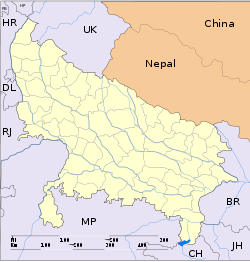
Nehtaur — city — Coordinates 29°20′N 78°23′E / 29.33°N 78.38°ECoordinates: 29°20′N 78°23′E / 29.33°N 78.38°E Country India State Uttar Pradesh District(s) Bijnor Population 44,301 (2001[update]) Time zone IST (UTC+05:30) Area
• 288 metres (945 ft)
Nehtaur or Nihtaur is a town in Bijnor district in the northern Indian state of Uttar Pradesh.
Contents
History
Tazeem Saifi Afzalgarh Nehtaur (also known as "Nehtaur Shareef") is an ancient and well known town because of its culture and educational backgrounds. Nehtaur was founded as one of the earliest Syed settlements in India, and remains to this day an integral part of Syed history in the nation. What started as a small settlement soon flourished into a textile hub and home to many rich and famous personalities.
During the British time lots of Syed and Tyagi got Jageer (wealth) as reward by the British and Nehtaur became upper class community hub. Syed and Tyagi dominated town and both community hold the entered economy[citation needed]. During that time, Nehtaur was very famous town in the state because of its higher educational status and its many people were graduates. Its Sanskrit pathshalas and Arabic madrasas were famous in the region [1]
When India was under the British Administration that time only Nehtaur was single town which had its own administration called “BARA TOPI SARKAR” 12 prominent and educated personalities belong from Syed community were run their own Government in Nehtour but unfortunately many people are not aware about it even majority of the Nehtauri’s don’t know about their own town history. It’s a proud for us as well as for the nation; Nehtaur had independent administration during the British period[citation needed].
When Sir Syed Ahmad Khan visited Nehtaur and asked people for their support and donation for Aligarh College. He was impressed by the town and its citizens due to their positive response and called the people of town as “Danishmandan-e-Nehtaur” or wise [1].
Geography
Nehtaur is located at 29°20′N 78°23′E / 29.33°N 78.38°E. It is situated at an altitude of 728 meters above sea level [2]. Operated by Uttar Pradesh State Road Transport Corporation (UPSRTC), Nehtaur Bus Station is a minor bus terminal and connects the town to state highway. Regular buses ply from Nehtaur to Dhampur, Bijnor, Nagina, Nurpur, Haldaur and Afzalpur. Also, the station provides short distance services to nearby places. The nearest railway station is Dhampur Railway Station [3].
Demographics
As of 2001 India census,[4] Nehtaur had a population of 44,301. Males constitute 52% of the population and females 48%. Nehtaur has an average literacy rate of 69%, higher than the national average of 59.5%: male literacy is 74%, and female literacy is 64%. In Nehtaur, 10% of the population is under 6 years of age.
Economics
Nehtaur is famous for Mango’s Cotton industries, its rich culture and harmony.
References
- ^ a b Hyder Yildirim, by Surayya Husain, Sahitya Akademi, p12
- ^ Falling Rain Genomics, Inc - Nihtaur
- ^ Nehtaur Bus Station
- ^ "Census of India 2001: Data from the 2001 Census, including cities, villages and towns (Provisional)". Census Commission of India. Archived from the original on 2004-06-16. http://web.archive.org/web/20040616075334/http://www.censusindia.net/results/town.php?stad=A&state5=999. Retrieved 2008-11-01.
Cities and towns in Bijnor district Bijnor Cities and towns
in other districtsAgra · Aligarh · Allahabad · Ambedkar Nagar · Auraiya · Azamgarh · Badaun · Bagpat · Bahraich · Ballia · Balrampur · Banda · Barabanki · Bareilly · Basti · Bhimnagar · Bulandshahr · Chandauli · Chhatrapati Shahuji Maharaj Nagar · Chitrakoot · Deoria · Etah · Etawah · Faizabad · Farrukhabad · Fatehpur · Firozabad · Gautam Buddha Nagar · Ghaziabad · Ghazipur · Gonda · Gorakhpur · Hamirpur · Hardoi · Jalaun · Jaunpur · Jhansi · Jyotiba Phule Nagar · Kannauj · Kanpur Nagar · Kanshi Ram Nagar · Kaushambi · Kushinagar · Lakhimpur Kheri · Lalitpur · Lucknow · Mahamaya Nagar · Maharajganj · Mahoba · Mainpuri · Mathura · Mau · Meerut · Mirzapur · Moradabad · Muzaffarnagar · Panchsheel Nagar · Pilibhit · Prabuddhanagar · Pratapgarh · Raebareli · Ramabai Nagar · Rampur · Saharanpur · Sant Kabir Nagar · Sant Ravidas Nagar · Shahjahanpur · Shravasti · Siddharthnagar · Sitapur · Sonbhadra · Sultanpur · Unnao · Varanasi
Categories:- Cities and towns in Bijnor district
Wikimedia Foundation. 2010.


