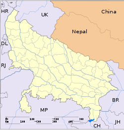
- Mandawar
-
Mandawar — city — Coordinates 29°30′N 78°08′E / 29.5°N 78.13°ECoordinates: 29°30′N 78°08′E / 29.5°N 78.13°E Country India State Uttar Pradesh District(s) Bijnor Population 19,565 (2001[update]) Time zone IST (UTC+05:30) Area
• 223 metres (732 ft)
Mandawar is a town and a nagar panchayat in Bijnor district in the Indian state of Uttar Pradesh. It is a green area near the holy river Ganges. Most people here are farmers.
Demographics
As of 2001[update] India census[1], Mandawar had a population of 19,565. Males constitute 52% of the population and females 48%. Mandawar has an average literacy rate of 39%, lower than the national average of 59.5%: male literacy is 45%, and female literacy is 33%. In Mandawar, 18% of the population is under 6 years of age.
Educational institutions
St.Paul's High School Established in 1992 by the 'Education Society of the Catholic Diocese of Bijnor' is a leading educational institution of the town. A Hindi Medium High School with a strength of 1500 students from the town and the villages around Mandawar receive quality education here. Mahatama Gandhi Inter College is the largest, oldest and the only Inter College in the Mandawar. It was established in approx 1967. Most of the children of the villages around Mandawar educated here. Adarsh Vidya Niketan Shahabazpur established in approx 1980, located in Kelawala [the four way point where the roads to the villages Shahabazpur and Mohandiya embark] one km far from Mandawar became Inter College in approx 2003 by the years hard work of Surendra Vishnoi, who was the Principal and starter of this school. A number of students do get education here, instead walking 2 km for Mahatama Gandhi Inter College in Mandawar.
References
- ^ "Census of India 2001: Data from the 2001 Census, including cities, villages and towns (Provisional)". Census Commission of India. Archived from the original on 2004-06-16. http://web.archive.org/web/20040616075334/http://www.censusindia.net/results/town.php?stad=A&state5=999. Retrieved 2008-11-01.
Cities and towns in Bijnor district Bijnor Cities and towns
in other districtsAgra · Aligarh · Allahabad · Ambedkar Nagar · Auraiya · Azamgarh · Badaun · Bagpat · Bahraich · Ballia · Balrampur · Banda · Barabanki · Bareilly · Basti · Bhimnagar · Bulandshahr · Chandauli · Chhatrapati Shahuji Maharaj Nagar · Chitrakoot · Deoria · Etah · Etawah · Faizabad · Farrukhabad · Fatehpur · Firozabad · Gautam Buddha Nagar · Ghaziabad · Ghazipur · Gonda · Gorakhpur · Hamirpur · Hardoi · Jalaun · Jaunpur · Jhansi · Jyotiba Phule Nagar · Kannauj · Kanpur Nagar · Kanshi Ram Nagar · Kaushambi · Kushinagar · Lakhimpur Kheri · Lalitpur · Lucknow · Mahamaya Nagar · Maharajganj · Mahoba · Mainpuri · Mathura · Mau · Meerut · Mirzapur · Moradabad · Muzaffarnagar · Panchsheel Nagar · Pilibhit · Prabuddhanagar · Pratapgarh · Raebareli · Ramabai Nagar · Rampur · Saharanpur · Sant Kabir Nagar · Sant Ravidas Nagar · Shahjahanpur · Shravasti · Siddharthnagar · Sitapur · Sonbhadra · Sultanpur · Unnao · Varanasi
Categories:- Cities and towns in Bijnor district
- Uttar Pradesh geography stubs
Wikimedia Foundation. 2010.


