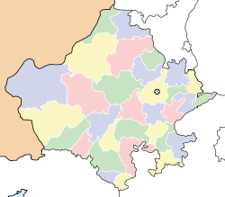
- Mandawar, Rajasthan
-
Mandawar — city — Coordinates 24°35′N 76°15′E / 24.58°N 76.25°ECoordinates: 24°35′N 76°15′E / 24.58°N 76.25°E Country India State Rajasthan District(s) Dausa Population 10,108 (2001[update]) Time zone IST (UTC+05:30) Area
• 343 metres (1,125 ft)
Mandawar is a census town in Dausa district in the Indian state of Rajasthan.
Contents
Geography
Mandawar is located at 24°35′N 76°15′E / 24.58°N 76.25°E. It has an average elevation of 343 metres (1125 feet).
About Mandawar
The town is well connected with rail route with Jaipur and Agra. Two major superfast trains "Udaipur - Gwalior Express 2965/2966" and "Marudhar Express from Jodhpur to Varanasi" stop here. Passenger trains are also available between Bandikui and Agra. Roads connect the town to Alwar via Rajgarh and Karauli via Mahua. National Highway Number 11 from Agra to Bikaner just pass through Mahua which is 15 km away from the town. The highway is four lane between Agra and Jaipur. Buses are available in big number to Jaipur and Agra and most of the cities of Rajasthan.
Demographics
As of 2001[update] India census[1], Mandawar had a population of 10,108. Males constitute 53% of the population and females 47%. Mandawar has an average literacy rate of 68%, higher than the national average of 59.5%: male literacy is 78%, and female literacy is 57%. In Mandawar, 16% of the population is under 6 years of age.
References
- ^ "Census of India 2001: Data from the 2001 Census, including cities, villages and towns (Provisional)". Census Commission of India. Archived from the original on 2004-06-16. http://web.archive.org/web/20040616075334/http://www.censusindia.net/results/town.php?stad=A&state5=999. Retrieved 2008-11-01.
Dausa Cities and towns
in other districtsAjmer · Alwar · Banswara · Baran · Barmer · Bharatpur · Bhilwara · Bikaner · Bundi · Chittorgarh · Churu · Dholpur · Dungarpur · Hanumangarh · Jaipur · Jaisalmer · Jalore · Jhalawar · Jhunjhunu · Jodhpur · Karauli · Kota · Nagaur · Pali · Pratapgarh · Rajsamand · Sawai Madhopur · Sikar · Sirohi · Sri Ganganagar · Tonk · Udaipur
Categories:- Cities and towns in Dausa district
- Rajasthan geography stubs
Wikimedia Foundation. 2010.


