- Dhampur
-
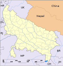
Dhampur — city — Coordinates 29°19′N 78°31′E / 29.32°N 78.52°ECoordinates: 29°19′N 78°31′E / 29.32°N 78.52°E Country India State Uttar Pradesh District(s) Bijnor Time zone IST (UTC+05:30) Area
• 216 metres (709 ft)
Dhampur is a city and a municipal board in Bijnor district in the state of Uttar Pradesh, India.
Contents
Geography
The neighboring villages are Mirzapur Palla(Pallawala)Dittanpur (Jittan Pur) Jaitra, Bari Mandi, Nindru, Naurangabad, Purana Dhampur, Sherkot, Suhagpur, Bholarampur, Alavalpur, Mohammadpur Sultan,Puraini,Morna and Habibwala,Milak Takhawali.
History
The Moghuls were defeated by Rohillas at Dhampur in 1750.
In 1805, Dhampur was sacked by Pindaris.[1]
This site is associated with Daaku Sultana, a nineteenth century dacoit (bandit) who was a supporter of the Indian freedom movement, but called dacoit by the British because he destroyed their stations, arms, ammunition and treasury.
Vidur Kuti is about 38 km from dhampur and having historical importance. Vidur spent his rest of life after dispute with Duryodhan. This is the place where Lord Krishana visited. Kanva Ashram is an ashram in broken condition near Rawli town according to the great legend "Abhigyan Shakuntalam". Hastinapur's King Dushyant reached there while hunting and fell in love with Shakuntala at first sight. During Mahabharat when the battle between Kauravas and Pandavas was about to begin, then on the request of both the sides, all wives and children were to be gaurdianed by Mahatma Vidur. He had no sufficient space for their living then he decided an exclusive area for ladies and children, which is now known as Daranagar. Ganj is about 40km from dhampur and 12 km from District HQ and just 1 km from Daranagar on the banks of the Ganges. There are ancient temples and ashrams.
historical place -kho bairaj ( sherkot) Ram Ganga bairaj ( harewali)Demographics
Dhampur had 12,046 inhabitants in 1941. As of 2001[update] India census,[2] Dhampur had a population of 46,855. Males constitute 53% of the population and females 47%. Dhampur has an average literacy rate of 65%, higher than the national average of 59.5%: male literacy is 68% and female literacy is 60%. In Dhampur, 15% of the population is under 6 years of age.
Economy
Dhampur's economy is based on agriculture, mainly sugarcane, wheat, and rice. Hand-woven textile items produced by the weavers living in surrounding areas are known for their utility and designs. The State Government set up a Handloom Intensive Development Project at Dhampur and several production centres are located in the area, with its central office headquartered at Kanpur.
One of the sugar producers in India, Dhampur Sugar Mills, is located here.[3] Set up in 1933, Dhampur Sugar Mills is a publicly listed sugar manufacturer, which produces the Dhampure brand of sugar products.
Religious places
- Maa Durga
- Jain tample
- Bada Shiv mandir (Jaitra)
- Shiv, Thakurdwara, Hori Maharaj (in Memory of the late Shri Hori Maharaj Ji, a Hindu activist)
- Baba Charandas Balaji Temple
- Gaddi Panap Das ji Maharaj
- Shri Sai Dham
- Gurudwara Panjabi Colony
- Rani ka mahal
- Rani bagh colony
Education
Educational institution in Dhampur are St' Mary's convent school, Shikhar Shishu Sadan school, Pushp Niketan School, R.S.M. Inter College, K.M. Inter College, Kanya Inter College, Priyanka Modern School, Saraswati Vidya Mandir .
There are five degree colleges in Dhampur: R.S.M. (PG) College, S.B.D. College, Disha institute of technology, Dhampur Law College and Dhampur Degree College.
Notable people
- Indra Pal Singh, former Cricket Ranjee Player.[4]
References
- ^ Columbia-Lippincott Gazeteer. New York: Columbia University Press (1952). p. 510
- ^ "Census of India 2001: Data from the 2001 Census, including cities, villages and towns (Provisional)". Census Commission of India. Archived from the original on 2004-06-16. http://web.archive.org/web/20040616075334/http://www.censusindia.net/results/town.php?stad=A&state5=999. Retrieved 2008-11-01.
- ^ The Hindu - Dhampur Sugar's expansion plans
- ^ Cricinfo
Cities and towns in Bijnor district Bijnor Cities and towns
in other districtsAgra · Aligarh · Allahabad · Ambedkar Nagar · Auraiya · Azamgarh · Badaun · Bagpat · Bahraich · Ballia · Balrampur · Banda · Barabanki · Bareilly · Basti · Bhimnagar · Bulandshahr · Chandauli · Chhatrapati Shahuji Maharaj Nagar · Chitrakoot · Deoria · Etah · Etawah · Faizabad · Farrukhabad · Fatehpur · Firozabad · Gautam Buddha Nagar · Ghaziabad · Ghazipur · Gonda · Gorakhpur · Hamirpur · Hardoi · Jalaun · Jaunpur · Jhansi · Jyotiba Phule Nagar · Kannauj · Kanpur Nagar · Kanshi Ram Nagar · Kaushambi · Kushinagar · Lakhimpur Kheri · Lalitpur · Lucknow · Mahamaya Nagar · Maharajganj · Mahoba · Mainpuri · Mathura · Mau · Meerut · Mirzapur · Moradabad · Muzaffarnagar · Panchsheel Nagar · Pilibhit · Prabuddhanagar · Pratapgarh · Raebareli · Ramabai Nagar · Rampur · Saharanpur · Sant Kabir Nagar · Sant Ravidas Nagar · Shahjahanpur · Shravasti · Siddharthnagar · Sitapur · Sonbhadra · Sultanpur · Unnao · Varanasi
Categories:- Cities and towns in Bijnor district
Wikimedia Foundation. 2010.


