- Colchester (borough)
-
Borough of Colchester — Non-metropolitan district, Borough — Colchester shown within Essex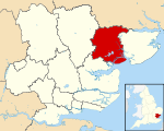
Sovereign state United Kingdom Constituent country England Region East of England Non-metropolitan county Essex Status Non-metropolitan district, Borough Admin HQ Colchester Incorporated 1 April 1974 Government – Type Non-metropolitan district council – Body Colchester Borough Council – Leadership Leader & Cabinet (Liberal Democrat / Labour / Independent) – MPs Bernard Jenkin
Priti Patel
Bob RussellArea – Total 128.6 sq mi (333.18 km2) Area rank 133rd (of 326) Population (2010 est.) – Total 181,000 – Rank 91st (of 326) – Density 1,407/sq mi (543.2/km2) – Ethnicity 93.5% White
2.0% S.Asian
1.1% Black
1.5% Mixed
1.8% Chinese or OtherTime zone GMT (UTC0) – Summer (DST) BST (UTC+1) ONS code 22UG OS grid reference TL997254 Website colchester.gov.uk Colchester is a local government district and borough in Essex, England, the district is named after its main town, Colchester. The borough covers an area of 125 square miles (320 km2) and stretches from Dedham Vale on the Suffolk border in the north to Mersea Island on the Colne Estuary in the south.
The borough was formed on April 1, 1974 by the merger of the former borough of Colchester with the urban districts of West Mersea and Wivenhoe, along with Lexden and Winstree Rural District.
Demographics
The Essex County Standard of September 4, 2009 said that "Government estimates" made Colchester the largest borough in the county: its officially acknowledged population is second highest among non-London boroughs, behind Northampton.
According to the Office for National Statistics as of 2008, Colchester had a population of approximately 181,000.[1] Average life expectancy was 78.7 for males. and 83.3 for females.[2]
Based on ethnic groups, predominantly of 92.1% of the population is White (86.9% British, 0.7% Irish and 4.5 other), Asians were the second largest making up 2.5% (1.1% Indian, 0.3% Pakistani and 0.3% Bangladeshi, other 0.8%), Blacks constituted 1.5% (0.4% Caribbean, 0.9% African, 0.1% other), those of mixed race made up 1.7% and the remaining were Chinese and other ethnic groups (2.2%).[3]
In the 2001 census, 71.6% identified themselves as Christian, while 18.5 % had no affiliation to a religion. Of other religions, 0.8% identified as Muslim, 0.5% Hindu, 0.4% Buddhist, 0.2 Jewish, 0.4% others, and 7.8% did not answer.[4] There are more than 100 churches located in Colchester: other religious places of worship include the Colchester Islamic Cultural Association and the Jewish Community Synagogue.
History
Colchester is the oldest recorded town in Britain, being founded by the Romans as their capital. Colchester was one of the three towns attacked by Boadicea. It is home to many historic buildings, including the Norman castle, built on the remains of a Roman temple; the Tudor town house, now Red Lion Inn, which was owned by the Howard family; a Saxon church and many more.
References
- ^ Colchester Resident Population ONS. Retrieved on 2010-03-07.
- ^ Colchester Life Expectancy ONS. Retrieved on 2010-03-07.
- ^ Colchester Ethnic Groups ONS. Retrieved on 2010-03-07.
- ^ Colchester Religion ONS. Retrieved on 2010-03-07.
The towns and villages of the Colchester borough of Essex, England Abberton • Aldham • Barrow Hill • Birch • Boxted • Colchester • Fingringhoe • Fordstreet • Marks Tey • Myland • Old Heath • Stanway • Tiptree • West Mersea • Wivenhoe • West Bergholt •
Islands: Mersea Island
 Districts of the East of England
Essex Basildon • Braintree • Brentwood • Castle Point • Chelmsford • Colchester • Epping Forest • Harlow • Maldon • Rochford • Southend-on-Sea • Tendring • Thurrock • Uttlesford
Hertfordshire Bedfordshire Cambridgeshire Norfolk Suffolk Categories:- Colchester
- Local government in Essex
- Non-metropolitan districts of Essex
- Local government districts of the East of England


Wikimedia Foundation. 2010.