- Chipping Ongar
-
Coordinates: 51°42′11″N 0°14′38″E / 51.703°N 0.244°E
Chipping Ongar 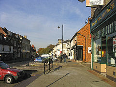
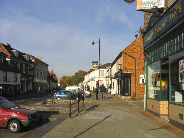
Chipping Ongar, High Street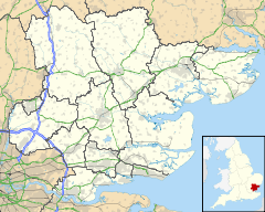
 Chipping Ongar
Chipping Ongar shown within EssexPopulation 6,069 [1] OS grid reference TL555035 Parish Ongar District Epping Forest Shire county Essex Region East Country England Sovereign state United Kingdom Post town ONGAR Postcode district CM5 Dialling code 01277 Police Essex Fire Essex Ambulance East of England EU Parliament East of England UK Parliament Brentwood and Ongar Website Ongar Town Council List of places: UK • England • Essex Chipping Ongar is a small market town, and a civil parish called Ongar, in the Epping Forest district of the county of Essex, England. It is located 5.4 miles (8.7 km) East of Epping, 6.5 miles (10.5 km) South-East of Harlow and 6 miles (9.7 km) North-West of Brentwood.
Contents
Geography
Ongar is located at the convergence of several old roads, being between Chelmsford and Epping on an east-west axis and between Dunmow and Chigwell (beyond which is London) on a north-south axis. To the south-east lies Brentwood, on the old road to the former River Thames ferry crossing at Tilbury, though the building in the 1970s of the M11 and M25 motorways means that Ongar is no longer directly on a principal route for petrol tankers (and other less prominent vehicles) travelling from the current Dartford Crossing and the Thames Estuary oil refineries.
The civil parish of Ongar, which has a town council, includes from north-to-south Shelley, Chipping Ongar and Marden Ash, with Greensted to the southwest.
The central part of Ongar High Street comprises a widened main street of the type found in many older English towns whose status as market towns is believed to have originated during the (little chronicled) Saxon period. The widened high street is used to permit some 'no charge' short term parking that benefits the local shops. The high street does however retain a very narrow stretch, with shops and houses either side very close to the road due to pavement that is barely adequate for two people to pass each other.
Much of the surrounding countryside is occupied by large mechanised farms devoted currently, for the most part, to arable agriculture. During the twentieth century the proximity of London encouraged dairy farming, but the 1960s, 1970s and 1980s were characterised by the removal of hedges and an increase in average field sizes as cattle numbers diminished. The subsoil is of heavy clay, rendering the land too soggy in winter for sheep, and inviting a greater level of attention to ditching and drain maintenance than has been applied to the district's road network since 1974.
History
Ongar was an important market town in the Mediaeval era, at the centre of a hundred and has the remains of a Norman castle (see below). The Church of England parish church of Saint Martin dates from the 11th century and shows signs of Norman work. A small window in the chancel is believed to indicate the existence of an anchorite's cell in mediaeval times.[2] The Gothic Revival architect C.C. Rolfe added the south aisle in 1884.[3]
Ongar's role in local government was downgraded in 1974 with the abolition of Epping and Ongar Rural District Council. By 1990 the area's baby boom generation had grown beyond secondary education and the town's secondary school (opened in 1936 with elegant neo-Georgian buildings fronting Fyfield Road, expanded greatly when it became a comprehensive in the 1960s) was closed despite vigorous local protest. Its buildings were demolished to make way for a new residential development. Secondary school age children from the area are bussed to school in surrounding towns, notably Brentwood and Shenfield. A sports centre and swimming pool, built in the 1970s to serve the comprehensive school, continue to serve the locality. Chipping Ongar Primary School, located on the Greensted Road at the southern edge of the town, and Shelley Primary School at the northern end of town remain. St. Andrew's Parish Church in Greensted is 2 miles (3.2 km) west of Ongar. It is believed to be the oldest wooden church in the world.[4] Several of the small private-sector businesses that operated through to the closing decades of the twentieth century have closed down or relocated as the economic focus of the region has been redirected, especially since the opening of the M11 motorway in the 1970s, to larger towns in west Essex, especially Harlow and Brentwood. Local planning policies have focused increasingly on residential development, and Ongar, like very many of the smaller towns in the belt round London, can be viewed primarily as a dormitory town for commuters to London, Brentwood, Harlow and Chelmsford. However, the single track rail line that connected Ongar to Epping (and thereby to London) was closed down in 1994 (see below) and local area road development has not been a priority in recent decades. Ongar also retains a range of retail shops. Jane Taylor, the author of Twinkle Twinkle Little Star, is buried in Ongar.[5] Chipping Ongar features in Will Self's novel, The Book of Dave.
The nursery rhyme "Twinkle Twinkle Little Star" is reported to have been written in Chipping Ongar. Knowleton hall is the most well known home in Ongar due to its interesting history.
Not to be confused with RAF Chipping Ongar, RAF Station Chipping Ongar (also known as Willingale) is a former World War II airfield in Essex, England. The airfield is located approximately 2 miles (3.2 km) northeast of Chipping Ongar; about 20 miles (32 km) northeast of London. Opened in 1943, it was used by both the Royal Air Force and United States Army Air Force. During the war it was used primarily as a bomber airfield. After the war it was closed in 1959 after many years of being a reserve airfield.
Ongar Castle
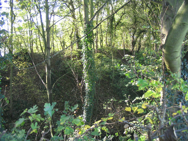
 The motte of Ongar Castle
Ongar Castle is a good example of a late 11th or early 12th Century Motte and Bailey, although only the earthworks survive. The motte or mound is about 70 metres in diameter at the base and is surrounded by a wet ditch up to 15 metres wide. A kidney-shaped inner bailey is to the west of the motte and there is a second bailey to the east. The remains of a town enclosure embankment extend to the west.[6]
The castle may have been built by Eustace II, Count of Boulogne who obtained the manor of Ongar in 1086. It was visited by King Henry II in 1157, when it was held by Richard de Lucy.[7] A stone keep was built on top of the motte, but this was pulled down in the 16th century and replaced by a brick building, itself destroyed in the 18th century. The motte itself is now covered with trees and is in private ownership, but can be seen from a public footpath that starts at the north end of the High Street.
Transport
Motorists
Ongar is a congested town which suffers from high volumes of traffic not only inside peak times but faces considerable weekend congestion much from locals driving into town and using one of three central car parks surrounding dense areas such as Sainsbury's and Tesco.
A graph from The Office of National Statistics gives an idea of how much congestion Ongar accommodates during peak periods. The portion of Car / Van drivers gives us an indication of local commuters.

Ongar is less than 25 miles from Central London, it is 6 miles to M11 J7 Harlow and 8 miles to M25 J28 Brentwood. The A414 runs between Chelmsford through Ongar to Harlow which in itself attracts a considerable amount of motorists wishing to join the M11 Harlow or M25 Brentwood.
Parking restrictions operate throughout the town centre where a 20 minute no return 2 hour scheme applies. Three Pay and Display car parks are available with a total 530 capacity.
Speeding restrictions lie at 30 mph between the High Street until the Four Wantz roundabout and The Stag Pub, the town's northern & southern ends respectively. One Gatso speed camera operates just off the Four Wantz roundabout enforcing the 30 mph restriction, however the town is very much included in the ' Essex Police Safer Roads Campaign ' where Police intercept motorists and / or occupants for safety belt fines, speeding tickets and operating a mobile phone whilst driving.
Local residents have previously called upon lowering the current National limit between The Mulberry House and the Four Wantz roundabout on the A414 Chelmsford bound. However, Essex Police Force's senior traffic management officer, Adam Pipe deemed lowering the speed limit " inappropriate, as drivers would feel 30mph is not adequate and would not comply ". Link - ThisIsTotalEssex.co.uk
Bus
The main towns buses serve are Brentwood, Chelmsford, Harlow and Epping.
Route Number Route Operational Details Operator 7/7A/7B Ivy Chimneys Spotted Dog / Epping Station  to Chelmsford Bus Station
  via North Weald
Mon-Fri, 5 return journeys. Times Regal Busways 20/21 Brentwood Warley Old Ford / Ongar Two Brewers to Harlow Bus Station via North Weald, Epping Mon-Sat about every 30 minutes. Route 20 operates Ongar-Epping-Harlow, route 21 operates Brentwood-Ongar-Epping-Harlow. SM Coaches 32 
Ongar Two Brewers to Chelmsford Bus Station via WrittleMon-Sat, 6 return journeys. Stephensons of Essex 46 Ongar Two Brewers to Moulsham Oaklands Park via Chelmsford Mon-Sat, 5 return journeys. Times First Essex 47 Ongar Two Brewers to Harlow Bus Station via Matching Tye Tuesdays and Thurs-Sat, 1 return journey. Times. Regal Busways 146 Ongar Two Brewers to Hatfield Heath White Horse via Fyfield Tuesday and Thursday, 1 return journey. Times. Regal Busways 380 Ongar Two Brewers to Harlow Bus Station via Epping, Epping Green, Roydon Mon-Fri 1 non-return journey. Times Regal Busways 501 Ongar Two Brewers to Harlow Bus Station via North Weald, Epping Sunday every 2 hours. Arriva Shires & Essex There are also school routes operated by N.I.B.S which are routes 434, 436, 437 operating to Shenfield schools and routes 471, 472, 473 operating to Brentwood schools.
Also see Essex Bus Routes.
Railway
Since the closure of the Central Line between Epping and Ongar in 1994, there is no longer a daily commuter train service in the town. The Epping Ongar Railway operates the former Central Line track, from North Weald Station on Sundays every hour to Ongar Station.
The nearest London Underground service to the town is Epping which is served by the Central Line. The closest National Rail service is from Brentwood, which is served by the Shenfield Metro and is operated by National Express East Anglia.
In popular culture
On the Who's album, Live at Leeds, Keith Moon refers to Chipping Ongar in a bit of stage banter as part of the introduction to their so-called "mini-opera," A Quick One, While He's Away. Guitarist Pete Townshend is in the middle of explaining the storyline to the audience, involving a lonely wife and her lover, Ivor the Engine Driver: "So what happens is uh, they uh, fu, they fornicate."
Moon interrupts to ask, "What's that, Pete? I thought it was a little station outside Chipping Ongar!" and Townshend tells him, "No no no."
Moon, who was the band's drummer, replies, "That's the trouble always sitting here in the back," to which Townshend deadpans back to the audience, "He always gets off at the wrong stop."[citation needed]
The endgame of Will Self's The Book of Dave takes place in Chipping Ongar.
In Ade Edmondson's book "How To Be A Complete Bastard", in the section on "How to be a Bastard to Japanese Tourists" he says "tell them all of London's tourist attractions are within walking distance of Ongar Tube"
In the BBC series Just Good Friends, Penny's mother and father live in Chipping Ongar.
Twinning
Sources
- Pearson, Lynn F.. Discovering Famous Graves. Princes Risborough: Shire Publications. p. 33.
- Pevsner, Nikolaus (1965). The Buildings of England: Essex. Harmondsworth: Penguin Books.
- Saint, Andrew (1970). "Three Oxford Architects". Oxonensia (Oxfordshire Architectural and Historical Society) XXXV: 53 ff. http://www.oahs.org.uk/oxo/vol%2035/Saint.doc. Retrieved 3 November 2009.
References
- ^ Epping Forest District Council: Parish Profile: Ongar
- ^ http://www.stmartinongar.org.uk/index.php?option=com_content&view=category&layout=blog&id=17&Itemid=10
- ^ Saint, 1970
- ^ http://www.britarch.ac.uk/ba/ba10/BA10NEWS.HTML
- ^ Pearson, page 33. N.b. contributor has not indicated whether of 1998 or 2004 edition.
- ^ http://unlockingessex.essexcc.gov.uk/custom_pages/monument_detail.asp?content_page_id=89&monument_id=871&content_parents=48
- ^ A History of the County of Essex: Volume 4: Ongar Hundred (1956), pp. 159-162,
External links
- Epping Ongar Railway
- Smith's Brasserie
- Mulberry House
- The Cock Tavern
- St Martin's Church
- The Ongar Millennium History Society
- www. com ltd
- Ongar Round Table
The District of Epping Forest Parishes Abbess Beauchamp and Berners Roding • Bobbingworth • Buckhurst Hill • Chigwell • Epping • Epping Upland • Epping Green • Fyfield • High Laver and Little Laver • High Ongar • Lambourne • Loughton • Magdalen Laver • Matching • Matching Green • Matching Tye • Moreton • Nazeing • North Weald Bassett • Chipping Ongar • High Ongar • Roydon • Sheering • Stanford Rivers • Stapleford Abbotts • Stapleford Tawney • Theydon Bois • Theydon Garnon • Theydon Mount • Waltham Abbey • WillingaleAttractions Constituencies Categories:- Towns in Essex
- Market towns in Essex
- Epping Forest

Wikimedia Foundation. 2010.