- Corringham, Essex
-
Coordinates: 51°31′21″N 0°27′43″E / 51.5224°N 0.462°E
Corringham 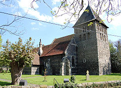
St. Mary's Church, Corringham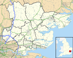
 Corringham
Corringham shown within EssexPopulation Maximum 8884 (2001)[1] OS grid reference TQ708832 Unitary authority Thurrock Ceremonial county Essex Region East Country England Sovereign state United Kingdom Post town STANFORD-LE-HOPE Postcode district SS17 Dialling code 01375 Police Essex Fire Essex Ambulance East of England EU Parliament East of England UK Parliament Basildon List of places: UK • England • Essex Corringham is a small English town within the unitary authority of Thurrock and one of the traditional (Church of England) parishes. It is situated in the east of the borough of Thurrock and has over time come to be considered an area within the larger neighbouring town of Stanford-Le-Hope. The parish church originated in the Saxon period. Corringham was formerly served by the Corringham Light Railway which connected the Kynoch munitions factory with the London, Tilbury and Southend Railway. It is one of the seven conservation areas within the Thurrock Unitary Authority.[2]
Contents
History
Origin of the Name
Thought to originate from derivation of a Saxon chieftain named Curra, the ‘ing’, which means followers, and ‘ham’ which means ‘home’[3]
The parish church
The south wall of the parish church contains examples of Saxon herringbone stonework in both the nave and the chancel.[4] There are other Saxon features inside the church. The tower is also likely to be Saxon.[5]
Schools in Corringham
Primary Schools
Corringham Primary School[6], Herd Lane. Age range 4–11 years Number of students: 412
Giffards Primary School[7], Queen Elizabeth Drive. Age Range 4–11 years Number of students: 469
Secondary
Gable Hall School[8][9], Southend Road A specialist performing arts and applied learning college Age Range: 11-16 No of students: 1,212
Notable people
- Dougie Poynter - bass player and vocalist in British pop-punk band, McFly.
- dan le sac - producer and vocalist in British Electro/Hip-Hop band, dan le sac Vs Scroobius Pip.
- Roy Hay (musician) - Lead Guitarist and Song Writer in ex-band Culture Club.
- Sue Hodge - Actress, best known for her role as the waitress Mimi Labonq in the BBC sitcom 'Allo 'Allo.
- Danny Crates - Paralympic 800m Athlete. Flag Bearer at Beijing 2008.
- Denise Van Outen - actress, singer and television presenter.
- Mark-Anthony Turnage - Composer
References
- ^ "Thurrock: Strategic Planning: Population" (PDF). www.thurrock-community.org.uk. January 2007. http://www.thurrock.gov.uk/planning/strategic/content.php?page=factsheet_07. Retrieved 2007-01-05.
- ^ Thurrock Council | Natural & Historic Environment | Conservation Areas In Thurrock
- ^ http://www.corringhamfobbingcf.org.uk/Core/CorringhamCf/Pages/Heritage_1.aspx
- ^ Stephen Pewsey and Andrew Brooks East Saxon heritage (Allan Sutton Publishing, 1993)
- ^ Potter, JE A Geological Review of Some Early Church Quoins in Essex Archaeology and History, Vol 36, 2005
- ^ http://www.schoolsnet.com/uk-schools/school-details-reviews/thurrock/corringham-primary-school/16180339/0/210046.html
- ^ http://www.schoolsnet.com/uk-schools/school-details-reviews/thurrock/giffards-primary-school/16180339/0/210043.html
- ^ http://www.schoolsnet.com/uk-schools/school-details-reviews/thurrock/gable-hall-school/16180339/0/210044.html
- ^ School website: http://www.gablehall.co.uk
Thurrock Traditional Parishes in Thurrock Aveley · Bulphan · Chadwell St Mary · Corringham · East Tilbury · Fobbing · Grays · Horndon-on-the-Hill · Little Thurrock · Mucking · Orsett · South Ockendon · Stanford-le-Hope · Stifford · West Thurrock · West TilburyOther places in Thurrock Baker Street · Biggin, Essex · Bill Meroy Creek · Chafford Hundred · Hangman's Wood · Lower Horse · Mardyke (river) · Orsett Heath · Purfleet · Rainham Marshes Nature Reserve · Shell Haven · Terrel's Heath · Tilbury TownCategories:- Towns in Essex
- Thurrock
- Populated places in Thurrock on the River Thames
- Places in Essex listed in the Domesday Book


Wikimedia Foundation. 2010.