- Welwyn Hatfield
-
Borough of Welwyn Hatfield — Non-metropolitan district, Borough — Welwyn Hatfield shown within Hertfordshire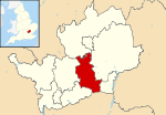
Sovereign state United Kingdom Constituent country England Region East of England Non-metropolitan county Hertfordshire Status Non-metropolitan district, Borough Admin HQ Welwyn Garden City Incorporated 1 April 1974 Government – Type Non-metropolitan district council – Body Welwyn Hatfield Borough Council – Leadership Leader & Cabinet (Conservative) – MPs Grant Shapps Area – Total 50 sq mi (129.55 km2) Area rank 199th (of 326) Population (2010 est.) – Total 114,400 – Rank 187th (of 326) – Density 2,287.1/sq mi (883.1/km2) – Ethnicity 89.0% White
4.0% South Asian
2.4% Black British
1.8% Mixed Race
2.9% Chinese or OtherTime zone GMT (UTC0) – Summer (DST) BST (UTC+1) ONS code 26UL OS grid reference TL245135 Website www.welhat.gov.uk The Borough of Welwyn Hatfield is a local government district in southern Hertfordshire, England.
Its covers the two towns of Welwyn Garden City and Hatfield, along with numerous smaller settlements from Woolmer Green in the north to Little Heath in the south. Each of the towns has a railway station on the East Coast Main Line and they are close to the A1 road. It borders the London Borough of Enfield.
The district was formed on 1 April 1974, as a merger of the Welwyn Garden City urban district, with the Hatfield and Welwyn rural districts.[1] It petitioned for borough status in 2005, which was agreed to by the Privy Council on 15 November 2005.[2] In April 2006 a charter conferring borough status was granted, and the title of the council officially changed to Welwyn Hatfield Borough Council on 22 May 2006.[3] The first Mayor of the borough, John Hawkins, was chosen on 22 May. Welwyn Hatfield issues are discussed in considerable detail on the Welwyn Hatfield Forum.
Set within the London green belt, the towns still retain something of their own identities despite the anomalous and often confusing name of Welwyn Hatfield which can make them sound as one.[4] Welwyn Garden City has a famous heritage being one of only two Garden Cities in the country, and is uniquely both Garden City and designated New Town. They function to some extent as dormitory towns for householders who work in London. The Welwyn Viaduct is a locally important landmark.
Following a proposal put forward by the Welwyn Garden Heritage Trust, Andres Duany, the internationally renowned town-planner, has suggested that designated 'Garden Villages' could be built within Hertfordshire to relieve some of the pressure for new homes, with perhaps a third Garden City to follow.
Politics
Elections to the council are held in three out of every four years, with one third of the 48 seats on the council being elected at each election. Since 1973 control of the council has alternated between the Conservative and Labour parties, with the Conservatives having controlled it since the 2002 election. At the last election in 2008 the Conservatives won 40 seats, compared to 5 for Labour and 3 for the Liberal Democrats.[5]
The borough boundary differs from Welwyn Hatfield parliamentary constituency only by the single ward of Northaw and Cuffley being within the borough, but in the parliamentary constituency of Broxborne. All other Welwyn Hatfield wards are the same for Borough and Constituency. Since 2005 Welwyn Hatfield Constituency has been represented by Conservative Grant Shapps.
References
- ^ HMSO. S.I. 1972/2039
- ^ Minutes of the Privy Council meeting on 15 November 2005.
- ^ Press Release, Welwyn Hatfield Council 16 May 2006.
- ^ Exemplified in a published letter of 21st July 2006 written to Rt. Hon. Ruth Kelly by Grant Shapps MP for Welwyn Hatfield concerning the unreasonable requirement for thousands of new homes within the borough. In his letter Grant Shapps writes in conclusion ; "The lack of consultation is shocking and demonstrated not least by the way the Panel continue to refer to Welwyn Hatfield as a single entity rather than the two separate and very distinctive towns that it actually is."
- ^ "Welwyn Hatfield". BBC News Online. 19 April 2008. http://news.bbc.co.uk/1/shared/bsp/hi/elections/local_council/08/html/26ul.stm. Retrieved 2010-03-11.
Ceremonial county of Hertfordshire Boroughs or districts Major settlements - Apsley
- Baldock
- Berkhamsted
- Bishop's Stortford
- Borehamwood
- Broxbourne
- Buntingford
- Bushey
- Cheshunt
- Harpenden
- Hatfield
- Hemel Hempstead
- Hertford
- Hitchin
- Hoddesdon
- Letchworth
- Potters Bar
- Radlett
- Rickmansworth
- Royston
- Sawbridgeworth
- St Albans
- Stevenage
- Tring
- Waltham Cross
- Ware
- Watford
- Welwyn Garden City
See also: List of civil parishes in Hertfordshire
Topics - Parliamentary constituencies
- Places
- SSSIs
- Visitor attractions
 Districts of the East of England
Essex Basildon • Braintree • Brentwood • Castle Point • Chelmsford • Colchester • Epping Forest • Harlow • Maldon • Rochford • Southend-on-Sea • Tendring • Thurrock • Uttlesford
Hertfordshire Broxbourne • Dacorum • East Hertfordshire • Hertsmere • North Hertfordshire • St Albans • Stevenage • Three Rivers • Watford • Welwyn Hatfield
Bedfordshire Cambridgeshire Norfolk Suffolk Coordinates: 51°46′00″N 0°11′30″W / 51.7666667°N 0.19167°W
Categories:- Welwyn Hatfield
- Non-metropolitan districts of Hertfordshire
- Local government districts of the East of England


Wikimedia Foundation. 2010.