- Cheshunt
-
Coordinates: 51°42′07″N 0°02′06″W / 51.702°N 0.035°W
Cheshunt 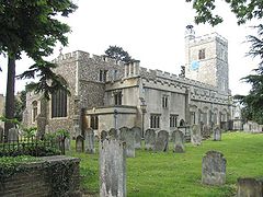
The Church of St Mary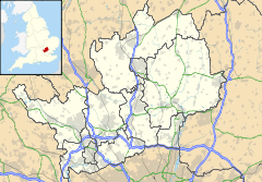
 Cheshunt
Cheshunt shown within HertfordshirePopulation 51,998 (Census 2001) OS grid reference TL358021 - London 13 mi (21 km) District Broxbourne Shire county Hertfordshire Region East Country England Sovereign state United Kingdom Post town Waltham Cross Postcode district EN7, EN8 Dialling code 01992 Police Hertfordshire Fire Hertfordshire Ambulance East of England EU Parliament East of England UK Parliament Broxbourne List of places: UK • England • Hertfordshire Cheshunt (
 /ˈtʃɛzənt/) is a town in Hertfordshire, England with a population of around 52,000 according to the United Kingdom's 2001 Census.[1] It is a dormitory town and part of the Greater London Urban Area and London commuter belt served by Cheshunt railway station. The town is located 13 miles (21 km) from Charing Cross, making it one of the closest parts of Hertfordshire to Central London.
Contents
History and geography
The Prime Meridian passes to the east of Cheshunt.
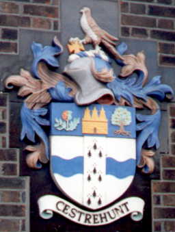
The town name comes from the Old English name (as recorded in the Domesday Book) for the area, Cestrehunt, which probably refers to a "castle, erected by the Romans", the word word cestre (along with the form ceastre), or even its modern forms, chester and caster being derived from the Latin castrum meaning "fort".[2][3] The town Chester also derives from this root and it is an element in various English place-names.[4] This is commemorated in the arms of the former Cheshunt urban district council.
Cheshunt was a settlement on Ermine Street, the main Roman road leading north from London. This origin was investigated by the television archaeology programme Time Team. Before the Norman Conquest, the manor of Cheshunt was held by Eddeva the Fair, but William I granted it to Alan of Brittany. The parish church of St Mary-the-Virgin was first recorded in a charter of 1146, but was entirely rebuilt between 1418 and 1448 with a three stage tower topped by an octagonal turret.[5]
As Princess Elizabeth, Queen Elizabeth I lived at Cheshunt in the care of Sir Anthony Denny, after she left Queen Catherine Parr's household in 1548.[6] Richard Cromwell, Lord Protector of the Commonwealth, died here in 1712.[7] In 1825, Cheshunt was also the location of the Cheshunt Railway. Running from the town's High Street to the River Lea near the present-day Cheshunt railway station, this 0.75 mi (1.21 km) horse-drawn line was the first passenger-carrying monorail and the first railway line to be built in Hertfordshire.[8][9]
The town's Bury Green neighbourhood was once the home of singer Cliff Richard. Lotus Cars as well as the nationally famous Debenhams were also founded in Cheshunt, and the headquarters of Tesco, the UK's largest and most profitable supermarket chain, is also located here. In 2002, Cheshunt hosted the only officially licensed European BotCon convention ever.
Services in Cheshunt include the Brookfield Centre, which includes Next, Boots, Krispy Kreme Doughnuts, Argos and Marks & Spencer stores, as well as a large Tesco Extra store. There is a Marriott Hotel nearby, and the town centre includes a wide variety of smaller shops.
Being located in the Lea Valley, Cheshunt has access to the Lee Valley Park.
At 8.00am on 12 August 1944 a Consolidated B-24 Liberator bomber belonging to 392nd Bombardment Group (Heavy) from RAF Wendling crashed next to Maxwells Farm (51°41′54″N 0°03′06″W / 51.698328°N 0.051610°W), near Cheshunt killing all ten crew.[10][11] The B198 which runs near the crash site has been renamed Lieutenant Ellis Way after the pilot had managed to avoid crashing into the nearby town, one of the Firemen who attended the scene has recently secured funding for a permanent crash memorial at the scene[12]
Up until 2004, Cheshunt was home to the famous Temple Bar, which was moved from London at the turn of the 19th century. The gateway was re-installed in London at Paternoster Square on the north side of St Paul's Cathedral.
Industry
Cheshunt's best-known employer is Tesco, whose head office has been in Cheshunt for many years. A small store has been in the town centre for many years and is still open today, together with an adjacent "Home 'n' Wear" store (now closed). [13] In 1983 a new out-of-town Tesco store located to the north of the town opened, named "Brookfield Farm". It later expanded, and a branch Marks & Spencer built next door, the entire estate renamed "The Brookfield Centre".
Until the late 1960s the main land use around Cheshunt was for its nursery industry, and many new techniques for growing under glass were developed here. Thomas Rochford had a large concern here, although now almost all the glasshouses have been re-developed into housing estates. This is often reflected in the names of the roads or estates, such as Rosedale or Thomas Rochford Way. A small amount of nursery trade survives to the west of the town. The neighbouring town of Goffs Oak still has a large number of nurseries as well as a large garden centre.
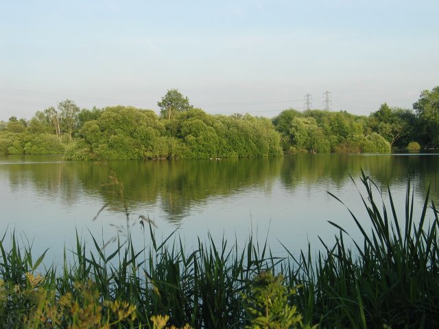
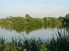 North Met Pit, flooded gravel workings
The River Lee Navigation passes through Cheshunt and was used for the transport of flowers and crops to the London markets for many years until road transport became more viable. A wharf existed just east of the railway on the site now occupied by Herts Young Mariners Base. The Youth Hostel was built on the site of the derelict open-air swimming pool.[14] Photos of the pool are exhibited at the hostel.
"Cheshunt Compound" a fungicide developed at the Cheshunt Research Station is still manufactured today.[15]
From the end of World War II a large area of the River Lea flood plain was used for sand and gravel extraction which resulted in the creation of the now mature lakes which are popular with anglers, birdwatchers and naturalists. The area now forms part of the 1,000 acres (400 ha) River Lee Country Park and the Turnford and Cheshunt Pits SSSI.
Education
Cheshunt has four secondary schools: St Mary's High School (C.E.); Cheshunt School; Goffs School; and Turnford School.
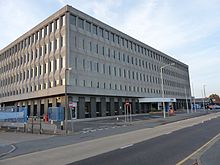
The non-conformist theological college Cheshunt College, moved to Cheshunt in the 1790s from Trevecca, Brecknockshire. It moved to Cambridge in 1905. Between 1909 and 1968 the buildings were occupied by the Church of England's Bishop's College.[16] Since 1972 they have been council offices.
Music
Cheshunt's best-known son is the rock singer Cliff Richard and the town was also home to the band Unit 4 + 2 whose song Concrete and Clay topped the UK charts in 1964. UFO drummer Andy Parker was born in the town in the 1950s.
The popular underground band Neils Children, who have recently gained attention, originally hail from Cheshunt.
Gary Prosser, singer in 90's Epic Pop Indie band Ballroom hails from Cheshunt.
Sport
Cheshunt has its own football Club in Cheshunt F.C. who play in the Isthmian League Division One North. Founded in 1946, their most famous player was Iain Dowie who played for them in the 1980s.
The town also has long-established rugby and cricket clubs and a publicly-owned 18-hole golf course.[17]
Transport
Road
Cheshunt is located on the A10 trunk road (also known locally as the Great Cambridge Road) which provides links to the M25 Junction 25, as well as to Enfield, London and the famous university city of Cambridge.
Bus
Cheshunt has a mixture of commercial and Hertfordshire County Council contract services. Most buses operate to Waltham Cross (where there are links to north London and Essex), Hoddesdon and Broxbourne. The towns of Hertford, Harlow, Cuffley, Potters Bar, and Waltham Abbey are also linked to Cheshunt. Buses are operated by Arriva, Centrebus, Metroline or Sullivan Buses.
Rail
Trains from Cheshunt railway station run into Liverpool Street and Stratford, with connections to the London Underground Victoria Line at Tottenham Hale and Seven Sisters. Away from London, Cheshunt trains serve Broxbourne, Hertford East, Stansted Airport and Cambridge.
Other nearby stations include Waltham Cross, Theobalds Grove, Enfield Lock, Cuffley. Oakwood and Cockfosters tube stations, on the Piccadilly Line, are located further afield.
Cycle
The Sustrans National Cycle Route 1 passes through Cheshunt as part of its route connecting Dover to Shetland.
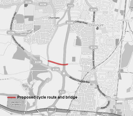
Proposed cycle bridge over A10
Cheshunt A10 Crossing 
Route of the proposed cycle link and new bridge location.Location Hertfordshire Proposer Sustrans cost estimate £1.7 million Geometry KML As part of the Connect2 project a proposal is in place to create a new cycle link over the A10.[18] The scheme involves the building of a new cycle bridge over the A10 and connecting paths to link Theobalds Lane with Lieutenant Ellis Way. The scheme aims to be complete in time to coincide with the opening of the new St Marys High School and has an estimated cost of £1.7m.[19] £500,000 of this cost is funded by the Big Lottery Fund via the Connect2 project. Planning permission has been granted for the scheme and it is currently in the design process.[20]
Notable people
- Michael Birch, founder of Bebo
- Michael Dobbs, writer and politician
- Billy Joe Saunders, boxer
- Richard Cromwell, died in Cheshunt
- Queen Elizabeth I - as Princess Elizabeth, lived here in her younger life
- Ralph Creed Meredith - Chaplain to George VI and Elizabeth II
Town twinning
 Stains, France, in northern Paris.
References
- ^ http://www.statistics.gov.uk/census2001/greater_london_urban_area.asp statistics.gov.uk
- ^ Tompkins, Herbert Winckworth (2008) Hertfordshire; illustrated by Edmund H. New; large print ed. BiblioBazaar, LLC ISBN 1437532349, 9781437532340 196 pages, page 190 http://books.google.co.uk/books?id=9bxP3iowDuAC
- ^ The Gentleman's Magazine. London: F. Jefferies, 1821; v. 91 pt. 1 Original from the University of Michigan; digitized 2 Aug 2005, page 521 http://books.google.co.uk/books?id=M_S10M8ze9MC
- ^ http://www.etymonline.com/index.php?term=Chester
- ^ http://www.british-history.ac.uk/report.aspx?compid=43640
- ^ http://www.oxfordinstitutepress.com/files/Oxford_Midas_Press_Release.pdf
- ^ Biography of Richard Cromwell Retrieved 04 December 2007
- ^ Finchley Society (1997-06-26). "Finchley Society Annual General Meeting Minutes". http://www.finchleysociety.org.uk/Newsletters/1990s/1997/6-97.pdf. Retrieved 2009-04-03.
- ^ Today in Science History. "June 25 - Today in Science History". http://www.todayinsci.com/6/6_25.htm. Retrieved 2009-04-03.
- ^ Lowewood Museum - B24 Liberator crash 1944
- ^ Rooke. P (1989) Cheshunt at War 1939-1945 ASIN: B003X2IH34
- ^ Hertfordshire Mercury - Ernie wins battle to honour US war heroes who saved Cheshunt (online newspaper accessed: 01/08/2010)
- ^ Tesco Home 'N' Wear Retrieved 19 April 2011
- ^ Herts Young Mariners Retrieved 05 April, 2010
- ^ Cheshunt compound Retrieved 2 September 2010
- ^ Article marking the centenary of the opening of Bishop's College, parish website http://www.cheshuntteamministry.org.uk/cms/index.php?option=com_content&view=article&id=21&Itemid=14
- ^ Cheshunt golf course Retrieved 22 March 2010
- ^ "Cheshunt, crossing the A10 to reach the Lee Valley". Sustrans. http://www.sustransconnect2.org.uk/schemes/project_detail.php?id=83. Retrieved 2009-07-23.
- ^ "East of England region update". Big Lottery Fund. 2009-07. http://www.biglotteryfund.org.uk/eastern/about-e/region-update-e.htm. Retrieved 2009-07-23.
- ^ "Borough of Broxbourne Minutes". Broxbourne Borough Council. 2008-07-22. http://www.broxbourne.gov.uk/pdf/MS-CO-281008-Minutes.pdf. Retrieved 2009-07-23.
External links
 Arms of the former Cheshunt Urban District Council
- Lee Valley Youth Hostel
- Additional Information about Cheshunt
- Lee Valley Park
- Cheshunt History
- Broxbourne Borough Council
- Lowewood Museum
- North Met fishery
- Cheshunt Comrades Club
Ceremonial county of Hertfordshire Boroughs or districts Major settlements Apsley · Baldock · Berkhamsted · Bishop's Stortford · Borehamwood · Broxbourne · Buntingford · Bushey · Cheshunt · Harpenden · Hatfield · Hemel Hempstead · Hertford · Hitchin · Hoddesdon · Letchworth · Potters Bar · Radlett · Rickmansworth · Royston · Sawbridgeworth · St Albans · Stevenage · Tring · Waltham Cross · Ware · Watford · Welwyn Garden City
See also: List of civil parishes in HertfordshireTopics Categories:- Towns in Hertfordshire
- Broxbourne


Wikimedia Foundation. 2010.