- King's Lynn and West Norfolk
-
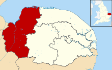
Borough of King's Lynn and West Norfolk — Borough — Shown within Norfolk Sovereign state United Kingdom Constituent country England Region East of England Administrative county Norfolk Founded Admin. HQ King's Lynn Government – Type Kings Lynn and West Norfolk Borough Council – Leadership: Leader & Cabinet – Executive: Conservative – MPs: Henry Bellingham (C)
Elizabeth Truss (C)Area – Total 551.7 sq mi (1,429 km2) Area rank 12th Population (2010 est.) – Total 143,600 – Rank Ranked 131st – Density 260.3/sq mi (100.5/km2) Time zone Greenwich Mean Time (UTC+0) – Summer (DST) British Summer Time (UTC+1) Postcode ISO 3166-2 ONS code 33UE OS grid reference NUTS 3 Ethnicity 98.7% White Website west-norfolk.gov.uk King's Lynn and West Norfolk is a local government district and borough in Norfolk, England. Its council is based in the town of King's Lynn.
History
The district was formed in 1974 by the merger of the Municipal Borough of King's Lynn, Hunstanton and Downham Market urban districts along with Docking Rural District, Downham Rural District, Freebridge Lynn Rural District and Marshland Rural District. The district was originally known as just West Norfolk, and adopted its present name in 1981.
Composition
The district comprises the urban area of King's Lynn itself, together with 102 surrounding parishes. At the time of the 2001 census, the district had an area of 1,473 km², of which 28 km² was in the urban area and 1,445 km² in the surrounding parishes. The district had a population of 135,345 in 58,338 households, with 34,564 in 15,285 households living in the urban area, whilst 100,781 people in 43,053 households lived in the surrounding parishes.[1]
The urban area of King's Lynn itself is unparished. The remainder of the district lies within the following civil parishes:
- Anmer
- Bagthorpe with Barmer, Barton Bendish, Barwick, Bawsey, Bircham, Boughton, Brancaster, Burnham Market, Burnham Norton, Burnham Overy, Burnham Thorpe
- Castle Acre, Castle Rising, Choseley, Clenchwarton, Congham, Crimplesham
- Denver, Dersingham, Docking, Downham Market, Downham West
- East Rudham, East Walton, East Winch, Emneth
- Feltwell, Fincham, Flitcham with Appleton, Fordham, Fring
- Gayton, Great Massingham, Grimston
- Harpley, Heacham, Hilgay, Hillington, Hockwold cum Wilton, Holme next the Sea, Houghton, Hunstanton
- Ingoldisthorpe
- Leziate, Little Massingham
- Marham, Marshland St. James, Methwold, Middleton
- Nordelph, North Creake, North Runcton, Northwold, North Wootton
- Old Hunstanton, Outwell
- Pentney
- Ringstead, Roydon, Runcton Holme, Ryston
- Sandringham, Sedgeford, Shernborne, Shouldham, Shouldham Thorpe, Snettisham, South Creake, Southery, South Wootton, Stanhoe, Stoke Ferry, Stow Bardolph, Stradsett, Syderstone
- Terrington St. Clement, Terrington St. John, Thornham, Tilney All Saints, Tilney St. Lawrence, Titchwell, Tottenhill
- Upwell
- Walpole, Walpole Cross Keys, Walpole Highway, Walsoken, Watlington, Welney, Wereham, West Acre, West Dereham, West Rudham, West Walton, West Winch, Wiggenhall St. Germans, Wiggenhall St. Mary Magdalen, Wimbotsham, Wormegay, Wretton
References
- ^ Office for National Statistics & Norfolk County Council (2001). Census population and household counts for unparished urban areas and all parishes. Retrieved December 2, 2005.
Boroughs or districts - Breckland
- Broadland
- Great Yarmouth
- King's Lynn and West Norfolk
- North Norfolk
- Norwich
- South Norfolk
Major settlements - Acle
- Attleborough
- Aylsham
- Cromer
- Dereham
- Diss
- Downham Market
- Fakenham
- Gorleston-on-Sea
- Great Yarmouth
- Hingham
- Holt
- Hunstanton
- King's Lynn
- Loddon
- North Walsham
- Norwich
- Redenhall with Harleston
- Reepham
- Sheringham
- Stalham
- Swaffham
- Thetford
- Thorpe St Andrew
- Watton
- Wells-next-the-Sea
- Wymondham
See also: List of civil parishes in Norfolk
Topics  Districts of the East of England
Essex Basildon • Braintree • Brentwood • Castle Point • Chelmsford • Colchester • Epping Forest • Harlow • Maldon • Rochford • Southend-on-Sea • Tendring • Thurrock • Uttlesford

Hertfordshire Bedfordshire Cambridgeshire Norfolk Breckland • Broadland • Great Yarmouth • King's Lynn and West Norfolk • North Norfolk • Norwich • South Norfolk
Suffolk Categories:- Local government in Norfolk
- King's Lynn and West Norfolk
- Non-metropolitan districts of Norfolk
- Local government districts of the East of England
Wikimedia Foundation. 2010.

