- Crimplesham
-
Coordinates: 52°36′22″N 0°26′07″E / 52.60602°N 0.43520°E
Crimplesham 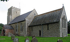
St Mary, Crimplesham
 Crimplesham
Crimplesham shown within NorfolkArea 6.63 km2 (2.56 sq mi) Population 221 - Density 33 /km2 (85 /sq mi) OS grid reference TF650037 Parish Crimplesham District King's Lynn and West Norfolk Shire county Norfolk Region East Country England Sovereign state United Kingdom Post town KING'S LYNN Postcode district PE33 Police Norfolk Fire Norfolk Ambulance East of England EU Parliament East of England List of places: UK • England • Norfolk Crimplesham is a village and civil parish in the English county of Norfolk. It is situated 4 km west of the small town of Downham Market, 20 km south of the larger town of King's Lynn, and 60 km west of the city of Norwich.[1]
The civil parish has an area of 6.63 km2 and in the 2001 census had a population of 221 in 94 households. For the purposes of local government, the parish falls within the district of King's Lynn and West Norfolk.[2]
History
In Saxon times , around 1040, Ailid a Freewoman is recorded as the owner of the manor of Crimplesham. In 1066 William the Conqueror seized the manor and gave it to Rainald, one of his barons. [3] And so on through medieval history, possession of Crimplesham passed from baron to baron, its owner often holding manors all over England. At one time it had ties to Bexwell, Downham Market and the Abbey at West Dereham.
In 1541 Francis Dereham of Crimplesham was hung, drawn and quartered by order of Henry VIII , accused of a pre-marital relationship with Catherine Howard.
In 1806 the Bagge family of Stradsett bought the manor from the daughter of the late Edward Soames, Lord of the manors of Dereham and Crimplesham. In 1880 a Liverpool banker called John Grant Morris [4] purchased some of the land , including the manor house, and built a new Hall as a gift on the marriage of his daughter to the second son of the Bagge family.Crimplesham Hall was designed by the eminent Victorian architect Alfred Waterhouse and completed in 1881.
Across the Main Road to the East of Crimplesham Hall is the Moated Site of another Manor House. A square moat exists but no trace of a building within. Norfolk Archeological Unit [5]call it Talbots Manor, and Crimplesham Hall they call The Prior of Tonbridge or Hall Manor
St Mary’s Church dates from 12C – 13C with later additions.
From the parish Registers: "Be it recorded in ye surviving memory of ye living, ye memorable act of Mr. Richd. Ward, Gent., then inhabitant in the towne of Crimplesham, who gave a trebble bell of three hundred and fifty weight to ye sayd towne, in the year of our Lord, 1651. May she be heard beyond the bounds of Ingratitude ; thus wisheth Thom. Wardner, Minist."
The church was restored by John Grant Morris in 1897.
In 1854 Mrs Elizabeth Doyle, living at Crimplesham Hall, invited Benjamin Benson, a former slave, to address the schoolchildren on the horrors of slavery. [6]. Mrs Doyle used to help clothe the poorer school children [7].
The school closed in 1984.References
- ^ Ordnance Survey (1999). OS Explorer Map 236 - King's Lynn, Downham Market & Swaffham. ISBN 0-319-21867-8.
- ^ Office for National Statistics & Norfolk County Council (2001). Census population and household counts for unparished urban areas and all parishes. Retrieved December 2, 2005.
- ^ History of Norfolk, Bloomfield 1808
- ^ Bankers Magazine vol 23 1863
- ^ Norfolk Records Office
- ^ Letters
- ^ Norfolk Heritage Explorer
External links
- Map sources for Crimplesham.
- Information from Genuki Norfolk on Crimplesham.
- Norfolk Heritage Explorer
Categories:- Villages in Norfolk
- King's Lynn and West Norfolk
- Civil parishes in Norfolk
- Norfolk geography stubs


Wikimedia Foundation. 2010.